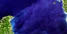
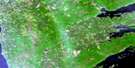
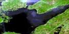
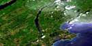
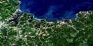
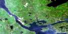
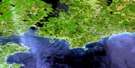
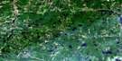
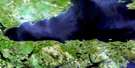
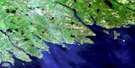
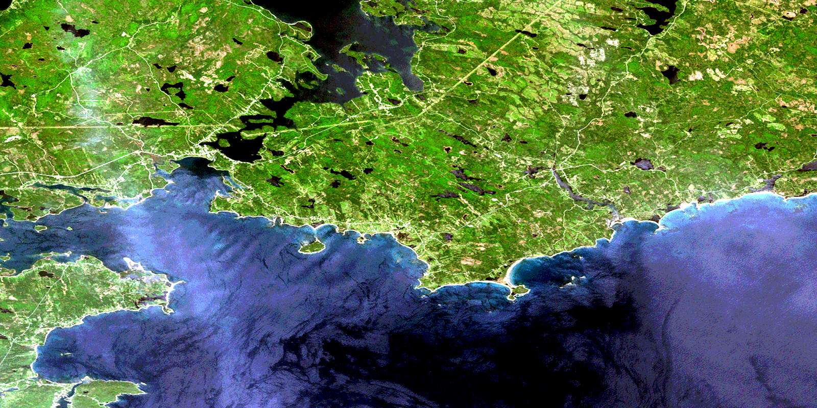
St Peter's Satellite Image Map
Download Free Aerial Photo 011F10 at 1:50,000 scale
St Peter's Satellite Imagery
To view this satellite map, mouse over the air photo on the right.
You can also download this satellite image map for free:
011F10 St Peter's high-resolution satellite image map.
Maps for the St Peter's aerial map sheet 011F10 at 1:50,000 scale are also available in these versions:
St Peter's Surrounding Area Aerial Photo Maps
 |
 |
 |
 |
 |
 |
 |
 |
 |
 |
 |
|
 |
 |
© Department of Natural Resources Canada. All rights reserved.
St Peter's Gazetteer
The following places can be found on satellite image map 011F10 St Peter's:
St Peter's Satellite Image: Bays
Anse à la DigueAnse du Loup
Arichat Goulet
Arichat Harbour
Barachois Cove
Barachois Harbour
Barachois Harbour
Bay of Rocks
Benjamins Cove
Bourgeois Inlet
Burkeys Cove
Cabbage Cove
Cape George Harbour
Carlos Cove
Carters Cove
Chapel Cove
Colins Cove
Corbetts Cove
Crawley Cove
Damions Cove
D'Escousse Harbour
Dog Cove
False Bay
Fougeres Cove
French Cove
Grand Goulet
Grande Greve Harbour
Hay Cove
Joe Bois Cove
John MacDonalds Cove
L'Archeveque Cove
Little Harbour
Little Harbour
Lynche Creek
MacNabs Cove
Major Creek
McNabs Cove
Michaud Cove
Petit-de-Grat Harbour
Petit-de-Grat Inlet
Ponds Cove
Poulamon Bay
Poulamon Harbour
Robertson Cove
Salmon Creek
Sampsons Cove
Shaws Cove
Small MacNabbs Cove
Small MacNabs Cove
Soldier Cove
Soldiers Cove
St. Peters Bay
St. Peters Inlet
Strachans Cove
The Goulet
Three Island Cove
West Bay
St Peter's Satellite Image: Beaches
Beak BeachGoulet Beach
L'Ardoise Beach
Little Breaker
Petit Nez Beach
Point Michaud Beach
Pondville Beach
Sandy Beach
Western Beach
St Peter's Satellite Image: Capes
Anatoles PointBar Cape
Bar Point
Beak Point
Benjamins Point
Black Point
Black Point
Bottle Head
Brick Point
Brickery Point
Burkes Point
Cap Rond
Cap Ronde
Cape George
Carter Point
Carters Point
Church Point
Clannon Point
Colins Point
Comeau Point
Cordeau Point
Cowley Point
Deep Point
Deepwater Point
Dock Point
Double Head
Doyles Cape
Flat Point
Fougeres Point
Fourgier Point
Freezer Point
Gabion Point
Godie Point
Grande Greve Point
Green Point
Gull Cape
Indian Point
Jane Point
Jerome Point
Kemps Point
Kempt Point
LaBelles Cape
L'Ardoise Head
Levesconte Point
Louis Point
MacLean Point
MacLeans Point
MacNabs Point
Macrae Point
MacRaes Point
Mark Point
Martin Point
Michaud Point
Narrows Point
Peggy Point
Petit Nez
Point Michaud
Pointe Brûlée
Pointe du Loup
Pothier Point
Poulamon Point
Ranteleau Point
Red Cape
Red Head
Red Point
Sand Point
Sandys Point
Savage Point
Scotch Point
Shaw Point
Sutherland Head
Sutherlands Head
Tillard Point
Trap Point
Twist Point
St Peter's Satellite Image: Channels
Beaver NarrowsLennox Passage
The Tickle
St Peter's Satellite Image: Cliffs
Jolly CliffSt Peter's Satellite Image: Geographical areas
RichmondSt Peter's Satellite Image: Indian Reserves
Chapel Island 5St Peter's Satellite Image: Islands
Abbois IslandAlick Island
Basque Island
Basque Islands
Beaver Island
Bernard Island
Birch Island
Bissett Island
Briands Island
Cape Breton Island
Cascarette Island
Chapel Island
Dicks Island
Doctor Island
Eagle Island
Evans Island
Green Island
Gregory Island
Gros Nez Island
Gull Island
Handleys Island
Hanleys Island
Hawk Island
Helens Island
Henris Island
Île du Cap-Breton
Indian Island
Indian Island
Isle Madame
Joe Sampsons Island
Langleys Island
Les Rochers
Les Rochers
Lindloffs Island
MacNabs Island
Marjorie Island
Ouetique Island
Outique Island
Petit-de-Grat Island
Petite Île
Potato Island
Red Island
Rocky Islets
Scotts Island
St. Peters Island
St Peter's Satellite Image: Lakes
Barachois PondBarren Hill Lake
Barren Lake
Barren Lake
Beauvais Lake
Benjamin Pond
Benjamins Pond
Bewes Pond
Bishop Lake
Bishops Lake
Black Point Lake
Black River Pond
Bras d'Or Lake
Brown Lake
Chisholm Dam Lake
Clannon Pond
Colin MacRaes Lakes
Condon Lakes
Condon Lakes
Condons Lake
Cook Lake
Cranberry Lake
Crawley Lakes
Delmars Lake
Donnellys Lake
Duncans Lake
Ephraims Pond
Evans Ponds
Ferguson Lake
Fergusons Lake
Fergusons Pond
Fergusons Pond
Finlayson Lake
Firmains Pond
First Lake
Garrets Lake
Gillis Lake
Hill Lake
Indian Lake
Island Lake
Jones Pond
Kemp Lake
Kemps Lake
Kennys Pond
Kyte Lake
Lac à Jean
Lac aux Menés
Lac des Justes
Lac Pourri
Lac Sec
Landrys Lake
Langlois Lake
L'Archeveque Lake
L'Ardoise Lake
L'Ardoise Long Lake
Latimers Pond
Little Barachois
Little Harbour Pond
Little Lake
Little Lake
Little MacLeod Lake
Little Round Lake
Little St. Esprit Lake
Lizzies Lake
Loch Cailean
Loch Lomond
Long Lake
Long Lake
MacAskills Lakes
MacKay Lake
Mackay Lake
MacKay Pond
MacKenzies Lake
MacLennan Lake
MacLeod Lake
MacLeods Lake
MacLeods Lakes
MacMullens Pond
MacNab Lake
MacNabs Lake
Maddox Pond
Maughers Pond
McDonald Lake
Mombourquettes Pond
Mountain Lake
Murphys Pond
Murray Lakes
Murrays Pond
Muskrat Lake
Narrow Lake
Narrow Pond
North Petit Nez Pond
Paddys Lake
Petit Barachois
Pringle Lake
Richards Pond
Rocky Lake
Rory Neils Lakes
Rorys Pond
Sampsons Pond
School Lake
Second Lake
Shaw Lake
Shaws Lake
Shaws Pond
Soldiers Cove Pond
South Petit Nez Pond
St. Esprit Lake
Stinking Pond
Stump Lake
Willow Pond
St Peter's Satellite Image: Mountains
Campbell HillCampbells Mountain
Mount Granville
Pringle Mountain
South Mountain
Sporting Mountain
Sporting Mountain
St Peter's Satellite Image: Major municipal/district area - major agglomerations
RichmondSt Peter's Satellite Image: Conservation areas
Battery Provincial ParkLieu historique national du Canada du Canal-de-St. Peters
Lieu historique national du Canada St. Peters
Pondville Beach Provincial Park
St. Peters Canal National Historic Site of Canada
St. Peters National Historic Site of Canada
St Peter's Satellite Image: Rivers
Barren Hill Lake OutletBlack Brook
Black River
Chisholm Brook
Dam Bridge Brook
Detter Creek
East River Tillard
Ebens Brook
Fergusons Lake Brook
Fougeres Brook
George Creek
Grand River
Isabelles Brook
Joes Brook
Kates Brook
Kavanagh Creek
Kennys Brook
MacAskills Brook
MacAskills Lakes Brook
MacCormicks Brook
MacDonald Brook
MacDonalds Brook
MacKay Brook
MacKay Lake Brook
MacKenzies Brook
MacKillop Brook
MacLeod Brook
MacNabs Brook
Marsh Brook
Matheson Brook
Maughers Brook
Millers Brook
Morrisons Brook
Murchison Brook
Murphys Brook
Paddys Brook
Pondville Brook
Pringle Brook
Rattling Brook
Reids Brook
River Bourgeois
River Tillard
River Tom
Salmon River
Schoolhouse Brook
Scott Brook
Scotts River
Smelt Brook
Smiths Brook
Soldiers Cove Brook
South Brook
Taylors Brook
Toms Brook
Urquhart Brook
Urquharts Brook
West Branch of Marie Joseph Brook
St Peter's Satellite Image: Shoals
Bad Neighbour ShoalBasque Reef
Basque Shoal
Bewes Shoal
Black Breaker Rock
Black Rock
D'Escousse Shoal
Flat Rock
Gabion Shoal
Goillon Reef
Goulet Beach Shoal
Haddock Rock
Horsehead Shoals
Indian Rock
Jean Maries Rock
Kate Rock
La Grosse Bosse
Long Bar
Mad Bull
Marchand Ledge
Mathesons Rock
Michaud Ledges
Morris Rock
Petit Nez
Petit Nez Shoal
Philip Rocks
Rose Rock
Rose Rocks
Round Shoal
Samson Rocks
Seal Rocks
Shag Ledge
The Rocher
Three Rocks
White Rock
St Peter's Satellite Image: Unincorporated areas
Barra HeadBarren Hill
Boudreauville
Cannes
Cap La Ronde
Cape George
Carters Cove
D'Escousse
Fergusons Lake
French Cove
Gracieville
Grand River
Grand River Falls
Grande Greve
Hawker
Hay Cove
Head of Loch Lomond
Jacksonville
L'Archeveque
L'Ardoise
L'Ardoise West
Lewis Cove Road
Little Harbour
Lochside
Lower L'Ardoise
Lynche River
McNabs Cove
Oban
Petit-de-Grat
Petit-de-Grat Bridge
Point Michaud
Poirierville
Pondville
Pondville South
Poulamon
River Bourgeois
River Tillard
Robins
Rockdale
Rocky Bay
Salmon River
Sampson Cove
Sampsons Cove
Sampsonville
Samsonville
Seaview
Soldiers Cove
Soldiers Cove West
South River Bourgeois
South Side River Bourgeois
Sporting Mountain
St. Esprit
Thibeauville
St Peter's Satellite Image: Villages
St. PetersSt. Peter's
© Department of Natural Resources Canada. All rights reserved.
