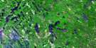
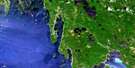
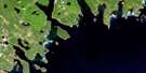
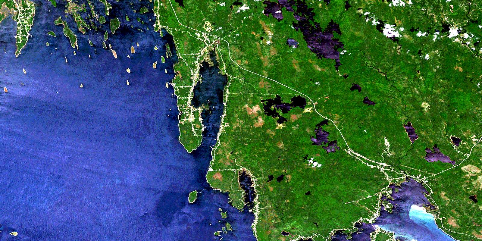
Pubnico Satellite Image Map
Download Free Aerial Photo 020P12 at 1:50,000 scale
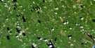
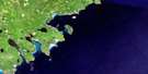
Pubnico Satellite Imagery
To view this satellite map, mouse over the air photo on the right.
You can also download this satellite image map for free:
020P12 Pubnico high-resolution satellite image map.
Maps for the Pubnico aerial map sheet 020P12 at 1:50,000 scale are also available in these versions:
Pubnico Surrounding Area Aerial Photo Maps
 |
 |
 |
|
 |
 |
||
 |
 |
||
© Department of Natural Resources Canada. All rights reserved.
Pubnico Gazetteer
The following places can be found on satellite image map 020P12 Pubnico:
Pubnico Satellite Image: Bays
Abbot HarbourAbbotts Harbour
Barrington Bay
Beach Cove
Big Cove
Browns Cove
Chebeck Cove
Clam Point Cove
Deep Cove
Doanes Cove
Doctor Cove
Doctors Cove
Donns Cove
East Bay
Goose Bay
Hospital Cove
Ironlock Bay
Jones Anchorage
Ledge Harbour
Little Bay
Lobster Bay
Lower Shag Harbour
Lyons Bay
Murray Cove
Otter Cove
Pubnico Harbour
Small Cove
Southwest Branch
The Basin
The Head
Upper Wood Harbour
Upper Woods Harbour
West Bay
Wood Harbour
Woods Harbour
Pubnico Satellite Image: Beaches
Allen FlatsGull Island Bar
Lyons Beach
Pubnico Beach
Sand Hills Beach
Sebim Beach
Whitehead Breaker
Pubnico Satellite Image: Capes
Beach PointBeach Point
Birch Point
Branch Neck
Brook Point
Burnt Point
Christies Neck
Clam Point
Clear Point
Clement Point
Clements Point
David Point
Dennis Point
Falls Point
Fish Point
Forbes Point
Goodwins Point
Goose Point
Green Point
Iron Point
Ironlock Point
Johns Island Spindle
Larkins Point
Liberty Point
Long Point
Maple Point
McCoys Point
Morton Neck
Muise Head
Newells Point
North East Point
Northern End
Oak Point
Old Point
Otter Point
Poplow Point
Porters Point
Pubnico Point
Rip Point
Southwest Point
St. Ann Point
Ste. Ann Point
Teachers Thumb
The Neck
The Ridge
Tusket Wedge
Wedge Point
Whistler Point
White Head
Wilson Point
Pubnico Satellite Image: Channels
Argyle SoundBakers Run
Ball Channel
Barrington Passage
Cockerwit Passage
Crique à Maurice
Eastern River
Goodwins Ditch
Hog Island Channel
Jones Channel
Lighthouse Channel
Old Point Channel
Passe aux Chats
Rum Passage
The Guzzle
The Narrows
The Sluice
Western Way
Wilson Channel
Pubnico Satellite Image: Falls
Big FallsChris Falls
Hells Gate
Island Falls
Long Falls
Phils Falls
Sorrow Falls
Weir Falls
Pubnico Satellite Image: Geographical areas
ShelburneYarmouth
Pubnico Satellite Image: Islands
Abbot IslandAbbotts Harbour Island
Angel Island
Angels Island
Bald Thrum
Bar Island
Big Fish Island
Big Gooseberry Island
Big Island
Birch Island
Blackberry Island
Board Islands
Bond Island
Bonds Island
Bramble Island
Calf Island
Calf Island
Camp Island
Canoe Island
Cape Sable Island
Carls Islands
Channel Island
Crazy Island
Double Island
Eagle Island
East Money Island
Eastern Bar Island
Egg Island
Elijahs Island
Etoile Island
Étoile Island
Far Point Island
Far-point Island
Fish Island
Flat Island
Flat Island
Flat Island
Fox Island
Frost Island
Globe Island
Goodwin Island
Goodwins Island
Gooseberry Island
Gordons Island
Grande Île
Great Thrum
Green Island
Gull Island
Hay Islands
Hemlock Island
Hog Island
Hog Island
Hog Island
Île à Picote
Ile au Blé
Île Chesapeake
Ile Ferré
Île Plate
Iles à Paul
Inner Fish Island
Inner Sheep Island
Jimmys Island
Johns Island
Jones Island
Kings Island
Kirby Island
Lamb Island
Lear Island
Lears Island
Little Fish Island
Little Gooseberry Island
Little Hog Island
Little Thrum
Lobster Island
Mike Island
Mikes Island
Morris Island
Muise Head Island
Mutton Islands
Nanny Island
Nannys Island
Outer Sheep Island
Paul Island
Peggy Island
Pinch Gut Island
Potato Island
Pumpkin Island
Ram Island
Ram Island
Ram Island
Rankin Island
Rankins Island
Raspberry Island
Rat Island
Robinson Ball
Roches à Marache
Roches Pointues
Round Island
Rum Island
Sheep Island
Sherose Island
Snipe Island
Soloman Island
Solomans Island
Squirrel Island
St. Helena Island
St. John Island
Stony Island
Stony Island
Sugarloaf Islet
Surettes Island
The Ball
The Brothers
The Little Punk
The Sugarloaf
The Thrum
The Thrum
Thrum Cap
Thrum Island
Tillys Island
Tom Banks Island
Tucker Island
Twin Islands
Vigneau Island
Watsons Yard Island
West Money Island
Western Bar Island
Whale Island
Whitehead Island
Wilson Island
Wooded Island
Pubnico Satellite Image: Lakes
Barrington LakeBeach Pond
Bear Point Pond
Black Georges Pond
Caesar Pond
Cleamons Pond
Clements Pond
Cranberry Pond
Duck Ponds
East Goose Lake
East Lake
Eastern Lake
Étang Bourgeois
Étang du Nord
First Lake
French Lake
Goose Lake
Grand Étang
Great Pubnico Lake
Ice Pond
Joshs Pond
Lily Pond
Little Madashack Lake
Little Pubnico Lake
Little Wabei Lake
Middle Lakes
Musquash Lake
Northwest Pond
Oak Park Lake
Oak-Park Lake
Ohio Lake
Pig Yoke Lake
Pig-yoke Lake
Pug Lake
Second Lake
Shag Harbour Pond
The Ponds
Third Lake
Wabei Lake
Wabei Slough
Wabi Lake
West Lake
Western Lake
Pubnico Satellite Image: Mountains
Birch HillBoudreaus Hill
Boudreaux Hill
Bull Hill
D'Eons Hill
Lyles Hill
Mathesons Lookout
Pine Hill
Raspberry Hill
Sam Crowells Hill
Stoddarts Hill
The Pinnacle
Wabei Hill
Pubnico Satellite Image: Major municipal/district area - major agglomerations
ArgyleBarrington
Shelburne
Pubnico Satellite Image: Conservation areas
Brothers Islands Wildlife Management Area, TheSand Hills Beach Provincial Park
Pubnico Satellite Image: Rapids
Indian StandPollys Place
The Falls
Pubnico Satellite Image: Rivers
Atwood BrookAtwoods Brook
Atwood's Brook
Barrington River
Birch Hill Brook
Black Georges Brook
Bloody Creek
Bog Brook
Clyde River
Cranberry Pond Brook
Crooked Brook
Deadhorse Brook
Downey Brook
Downeys River
Eyeball Run
French Creek
French Lake Brook
Fresh Brook
Freshwater Stream
Goose Creek
Hardens Brook
Hardings Brook
Judas Creek
Little Brook
Little Goose Creek
Little Run Brook
Little Wabei Brook
Long Run
Lyles Hill Brook
MacDonalds Creek
Middle Lakes Branch
Musquash Branch
Northwest Brook
Potter Run Brook
Potters Run
Sams Brook
Shag Harbour Brook
Shag Harbour River
Shag-harbour River
Silver River
Skuddiunk Brook
Slough Brook
Southwest Branch Brook
Stalkers Run
The Branch
Three Brooks
Thurstons Creek
Tusket River
Wabei Branch
Welchards Brook
West Branch
Wine Brooks
Pubnico Satellite Image: River features
Chalk Line SoundGlasgow Stillwater
The Stillwater
Pubnico Satellite Image: Sea features
The TittlePubnico Satellite Image: Shoals
Angus ShoalBall Bar
Ball Ledge
Barrel Rock
Beach Cove Shoal
Big Fish Rocks
Big Ledge
Black Ledge
Brant Ledges
Camp Island Shoal
Carpenter Ledge
Cook Point Ledges
Cross Ledge
Cunningham Reef
Dangle Rock
Deadmans Ledge
Dollard Rock
Etelle Ledge
Ételle Ledge
Fish Ledge
Foul Ground
Frost Island Ledge
Gleaner Rock
Goose Bay Ledges
Green Island Ledge
Gull Bar
Gull Island Shoal
Gull Ledge
Gunning Ledge
Half Tide Ledge
Hemlock Shoals
Hog Island Ledge
Hoptoad Ledge
Horsehead Shoal
Huskins Reef
Johns Island Ledge
Jones Ledge
Kelp Shoal
Latour Rock
Lears Island Ledge
Lighthouse Rock
Little Hog Island Ledge
Liverpool Ledge
Liverpool Reef
Lobster Ledge
Lobster Rock
Lone Rock
Long Reef
Long Reef
Lous Ledge
Lyons Ledges
Mid Ledge
Money Ledge
Morris Bank
Nanny Island Reef
Nickersons Bar
Nickersons Rock
North Angle Ledge
Northern End Ledge
Nubble Rock
Old Beacon Rocks
Old Woman
Pioneer Rock
Potato Ledge
Privateer Ledge
Pubnico Ledge
Pumpkin Island Shoal
Pumpkin Ledge
Ram Island Ledges
Rams Ledge
Roche à Chicot
Roche à Frédéric
Rodman Rock
Round Shoal
Snake Reef
Snipe Reef
Solomans Island Ledge
South Angle Ledge
Southwest Shoal
St. Ann Shoal
St. John Ledge
Sugar Ledge
Sunken Ledge
Sylvin Ledge
Tarrio Ledge
The Brother Rocks
The Lump
The Peak
Tom Cod Rock
Tucker Island Ledge
Two Rock Ledge
Underpinning Ledge
Wesses Ledge
West Shoal
Western Shoal
Western Way Ledge
Western Way Ledges
Whale Island Bar
Whitehead Ledge
Pubnico Satellite Image: Unincorporated areas
Argyle SoundArgyle South
Atwood Brook
Atwoods Brook
Atwood's Brook
Atwoods Brook Station
Barrington
Barrington
Barrington Head
Barrington Passage
Barrington West
Brass Hill
Central Wood Harbour
Central Woods Harbour
Centre East Pubnico
Charlesville
Coffinscroft
Crowell
D'Entremont
Doctor Cove
Doctors Cove
East Pubnico
Forbes Point
Knowles
Lower Argyle
Lower East Pubnico
Lower Shag Harbour
Lower Wedgeport
Lower West Pubnico
Lower Wood Harbour
Lower Wood Harbour
Lower Woods Harbour
Middle East Pubnico
Middle West Pubnico
North East Point
Oak Park
Pubnico
Riverhead
Sherose Island
Upper West Pubnico
Upper Wood Harbour
Upper Wood Harbour
Upper Woods Harbour
Villagedale
Wedgeport
West Pubnico
Wood Harbour
Pubnico Satellite Image: Low vegetation
Beartrap SwampBlack Georges Savannah
Christies Plains
Cranberry Bog
Dirty Creek Bog
Eastern Flats
Fungi Ground
Gibsons Meadow
Hines Savannah
Hughies Meadow
Little Brook Savannah
Long Savannah
Lowes Meadows
Lyles Hill Savannah
The Big Grassy
© Department of Natural Resources Canada. All rights reserved.
