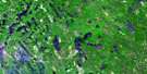
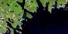
Port Mouton Satellite Image Map
Download Free Aerial Photo 020P15 at 1:50,000 scale
Port Mouton Satellite Imagery
To view this satellite map, mouse over the air photo on the right.
You can also download this satellite image map for free:
020P15 Port Mouton high-resolution satellite image map.
Maps for the Port Mouton aerial map sheet 020P15 at 1:50,000 scale are also available in these versions:
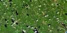
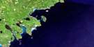
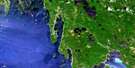
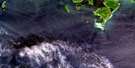
Port Mouton Surrounding Area Aerial Photo Maps
 |
 |
 |
|
 |
 |
||
 |
 |
||
© Department of Natural Resources Canada. All rights reserved.
Port Mouton Gazetteer
The following places can be found on satellite image map 020P15 Port Mouton:
Port Mouton Satellite Image: Bays
Birch CoveBoyds Cove
Boyd's Rock Cove
Cadden Bay
Channel Cove
Duck Lake Bay
Fishers Cove
Forbes Cove
Gull Bay
House Cove
Isaacs Harbour
Island Cove
John Smiths Cove
Joli Basin
Jones Cove
Jones Harbour
Little Joli Bay
Little Port Hebert
Little Port Joli
Little Port Joli Basin
Little Port Joli Creek
Little Port L'Hebert
Long Cove
MacLeods Cove
New Building Cove
Newhouse Cove
Port Hebert
Port Joli
Port L'Hebert
Port Mouton
Rocky Cove
Sandy Bay
Sandy Cove
Schooner Cove
St. Catherines River Bay
Tarr Cove
The Cove
Timber Island Cove
Willow Cove
Port Mouton Satellite Image: Beaches
Back BeachBoyds Beach
Carters Beach
Green Side Shore
Hatt Beach
Hunts Point Beach
Johnstons Beach
Jumping Jack Breaker
Lighthouse Beach
Sandy Bay Beach
St. Catherines River Beach
Summerville Beach
Tarr Cove Breaker
White Point Beach
Wobamkek Beach
Port Mouton Satellite Image: Capes
Bell PointBills Point
Black Point
Black Point
Black Point
Broad Head
Broad River Head
Bull Point
Davenport Point
Dry Point
Duck Point
East Point
Forbes Point
Grosse Spit
Halibut Head
Hell Point
Hook Point
Hunts Point
Joli Point
Jones Harbour Point
MacDonald Point
Mitchell Point
Mouton Head
Port Joli Head
Port Mouton Head
Richardson Head
Scotch Point
Shingle Point
South Point
Strawberry Point
Stuarts Point
Thrum Point
Tillys Head
Western Head
White Point
Wreck Point
Port Mouton Satellite Image: Channels
Eastern ChannelWestern Channel
Port Mouton Satellite Image: Falls
Campbells FallsPort Mouton Satellite Image: Geographical areas
QueensShelburne
Port Mouton Satellite Image: Islands
Big Timber IslandCarters Island
Charley Island
Daury Island
Grants Island
Green Island
Gull Island
Hardings Island
Jacket Island
Jackies Island
Johns Island
Lesser Hope Island
Little Hope Island
Little Timber Island
Massacre Island
Mink Island
Money Island
Mouton Island
Port Mouton Island
Sinclair Island
Spectacle Island
Spectacle Islands
Stuarts Island
Thrum Cap
Timber Island
Port Mouton Satellite Image: Lakes
Basin LakeBoyds Cove Ponds
Bull Pond
Cameron Lake
Cove Lake
Cranberry Pond
Deep Lake
Doggetts Pond
Duck Hole
Duck Lake
Flat Lake
Flat Lake
Forbes Lake
Haley Lake
Head Pond
Huskins Pond
Johnston Pond
Johnstons Pond
Lillie Lake
Lily Lake
Little Duck Hole
Little Lake
Little Lake
Little Robertsons Lake
Long Lake
Louis Lake
McLean Lake
Meadow Lake
Moose Creek Pond
Path Lake
Robertson Lake
Robertsons Lake
Round Lake
Sandy Bay Round Lake
Sodom Lake
Southern Deep Lake
St. Catherine Lake
St. Catherines Lake
St. Catherines River Lake
Stewart Lake
Stuarts Lake
The Pond
Tripps Lake
Trips Lake
Victoria Lake
Wilkins Lake
Willis Lake
Port Mouton Satellite Image: Mountains
Beech HillGoose Hills
Hammetts Ridge
Port Mouton Satellite Image: Major municipal/district area - major agglomerations
QueensShelburne
Port Mouton Satellite Image: Conservation areas
Annexe côtière du parc national KejimkujikHaley Lake Bird Sanctuary
Kejimkujik National Park of Canada
Kejimkujik National Park Seaside Adjunct
Parc national du Canada Kejimkujik
Port Hebert Bird Sanctuary
Port Hebert Migratory Bird Sanctuary
Port Joli Bird Sanctuary
Refuge d'oiseaux de Port Hébert
Refuge d'oiseaux de Port-Joli
Refuge d'oiseaux du lac Haley
Refuge d'oiseaux migrateurs de Port Hébert
Summerville Beach Provincial Park
Thomas Raddall Provincial Park
Port Mouton Satellite Image: Rivers
Broad RiverCalfpen Brook
Carters River
Cox Creek
Cox Creek
Cox Creek Brook
Douglas Brook
East Branch Five Rivers
East Broad River
East Brook Five Rivers
Five River Creek
Five Rivers
Five Rivers Creek
Granite Brook
Granite Village Brook
Haley Lake Brook
Hemeon Brook
Indian Log Brook
Jones Creek
Little Lake Brook
London Brook
MacLarens Creek
Martin Brook
McAlpine Brook
McAlpines Brook
Mitchell Brook
Path Lake Brook
Payzant Brook
Reubens Brook
Rosies Brook
Sable River
St. Catherines River
Timber Island Brook
Timber-island Brook
Tobacco Brook
Vances Brook
Wagner Brook
Wagners Brook
Port Mouton Satellite Image: River features
Campbells StillwaterDevils Funnel Stillwater
Long Point Stillwater
Maple Swamp Stillwater
McQuinns Stillwater
Seans Hole
Port Mouton Satellite Image: Shoals
BantamBastard
Big Ball Rock
Big Ledges
Bijou Rocks
Boyds Reef
Brazil Rocks
Bull Rock
Burgess Rock
Darlings Rock
Deadmans Rock
Devastation Shoal
Entry Rock
Green Rock
Gull Shoal
Harbour Rocks
Hebert Rocks
Hebert Rocks
Herring Rocks
Lesser Hope Rock
L'Hebert Rocks
Little Ball Rock
Little Hope Shoal
MacLarens Rock
Main Ledges
Middle Rock
Moose Rock
Round Rock
Shingle Rock
South Rock
Spectacle Ledge
Spectacle Rock
The Blinds
The Old Bull
The Old Cow
Whaleback
White Point Rock
White Point Shoal
Port Mouton Satellite Image: Unincorporated areas
Beach Hill FarmsBeech Hill Farms
Central Port Mouton
East Side Port Hebert
East Side Port L'Hebert
Granite Village
Hunts Landing
Hunts Point
Little Port Hebert
Little Port L'Hebert
Port Hebert
Port Joli
Port L'Hebert
Port Mouton
River Head
Sandy Bay Landings
South West Port Mouton
St. Catherine River
St. Catherines River
Summerville Centre
Western Head
White Point
Wilkins
Port Mouton Satellite Image: Low vegetation
Cranberry BogLeslies Meadows
Payzant Meadows
Skullbone Bog
Sols Meadows

© Department of Natural Resources Canada. All rights reserved.
