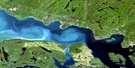
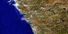
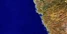
Pic Island Satellite Image Map
Download Free Aerial Photo 042D10 at 1:50,000 scale
Pic Island Satellite Imagery
To view this satellite map, mouse over the air photo on the right.
You can also download this satellite image map for free:
042D10 Pic Island high-resolution satellite image map.
Maps for the Pic Island aerial map sheet 042D10 at 1:50,000 scale are also available in these versions:
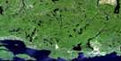
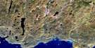
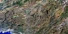
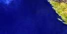
Pic Island Surrounding Area Aerial Photo Maps
 |
 |
 |
 |
 |
 |
 |
 |
 |
|||
 |
© Department of Natural Resources Canada. All rights reserved.
Pic Island Gazetteer
The following places can be found on satellite image map 042D10 Pic Island:
Pic Island Satellite Image: Bays
Ashburton BayBottle Cove
Cork Cove
Devils Cove
Johnson Harbour
McGreevy Harbour
Peninsula Bay
Port Coldwell
South Bay
Sunday Harbour
Windy Bay
Pic Island Satellite Image: Capes
Bottle PointColdwell Peninsula
Guse Point
Lone Pine Point
Moss Point
Pic Island Satellite Image: Channels
Devils GapJackfish Channel
Thompson Channel
Pic Island Satellite Image: Islands
Allouez IslandCape Island
Cape Islet
Cove Island
Delaute Island
Detention Island
Dupuis Island
Fish Island
Fish Islet
Foster Island
François Island
François Islet
Leadman Island
Leadman Islands
McDonald Island
McDonald Islands
Mortimer Island
Patterson Island
Pear Island
Pearl Island
Pic Island
Shell Island
Slate Islands
Spar Island
Spar Islet
Sullivan Island
Pic Island Satellite Image: Lakes
Duck LakeFenn Lake
Floating Island Lake
Heather Lake
High Dam Lake
Lac Supérieur
Lake Superior
Logging Camp Lake
Long Lake
Messy Lake
Mud Lake
No Name Lake
North Bladder Lake
North Twin Lake
South Bladder Lake
South Twin Lake
Swim Lake
Triangle Lake
Two Bog Lake
Veronica Lake
Pic Island Satellite Image: Mountains
Mount PremierPremier Mountain
Pic Island Satellite Image: Other municipal/district area - miscellaneous
Terrace BayPic Island Satellite Image: Conservation areas
Neys Provincial ParkSlate Islands Provincial Park
Pic Island Satellite Image: Shoals
Black RockFred Shoal
Hale Rock
McKay Rocks
Nicoll Shoal
Slyboots Rock
Pic Island Satellite Image: Towns
Marathon
© Department of Natural Resources Canada. All rights reserved.
