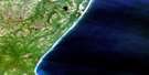
Lawnhill Satellite Image Map
Download Free Aerial Photo 103G05 at 1:50,000 scale
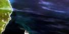
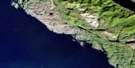
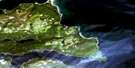
Lawnhill Satellite Imagery
To view this satellite map, mouse over the air photo on the right.
You can also download this satellite image map for free:
103G05 Lawnhill high-resolution satellite image map.
Maps for the Lawnhill aerial map sheet 103G05 at 1:50,000 scale are also available in these versions:
Lawnhill Surrounding Area Aerial Photo Maps
 |
 |
 |
|
 |
 |
 |
|
 |
 |
 |
|
 |
© Department of Natural Resources Canada. All rights reserved.
Lawnhill Gazetteer
The following places can be found on satellite image map 103G05 Lawnhill:
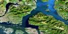
Lawnhill Satellite Image: Bays
Halibut BightRooney Bay
Shingle Bay
Skidegate Inlet
Village Bay
Lawnhill Satellite Image: Capes
Dead Tree PointLawn Point
Spit Point
Lawnhill Satellite Image: Channels
Hecate StraitLawnhill Satellite Image: Indian Reserves
Réserve indienne Skaigha 2Réserve indienne Skidegate 1
Skaigha Indian Reserve 2
Skidegate Indian Reserve 1
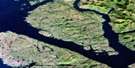
Lawnhill Satellite Image: Islands
Bare IslandGraham Island
Moresby Island
Torrens Island
Wilcox Group
Lawnhill Satellite Image: Mountains
Lawn HillLawnhill Satellite Image: Rivers
Chinukundl CreekJungle Creek
Lawn Creek
Leander Creek
Miller Creek
Slarkedus Creek
Tlell River
Lawnhill Satellite Image: Shoals
Bar RocksLawnhill Satellite Image: Unincorporated areas
HaidaLawn Hill
Lawnhill
Sandspit
Skidegate
Skidegate Mission

© Department of Natural Resources Canada. All rights reserved.
