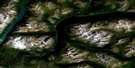
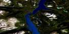
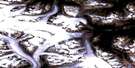
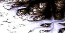
Fantail Lake Satellite Image Map
Download Free Aerial Photo 104M09 at 1:50,000 scale
Fantail Lake Satellite Imagery
To view this satellite map, mouse over the air photo on the right.
You can also download this satellite image map for free:
104M09 Fantail Lake high-resolution satellite image map.
Maps for the Fantail Lake aerial map sheet 104M09 at 1:50,000 scale are also available in these versions:
Fantail Lake Surrounding Area Aerial Photo Maps
 |
 |
 |
 |
 |
 |
 |
 |
 |
 |
 |
|
 |
 |
© Department of Natural Resources Canada. All rights reserved.
Fantail Lake Gazetteer
The following places can be found on satellite image map 104M09 Fantail Lake:
Fantail Lake Satellite Image: Bays
Deep BayGraham Inlet
Taku Arm
Fantail Lake Satellite Image: Capes
Indian PointFantail Lake Satellite Image: Channels
Golden GateFantail Lake Satellite Image: Lakes
Brownlee LakeFalse Lake
Fantail Lake
Lowry Lake
Racine Lake
Tagish Lake
Fantail Lake Satellite Image: Mountains
Bee PeakBoundary Ranges
Chaîne Côtière
Coast Mountains
Ear Mountain
Golden Mountain
Hale Mountain
Mount Brook
Mount Clive
Mount Fetterly
Sunday Peak
Tagish Highland
Fantail Lake Satellite Image: Rivers
Bighorn CreekBuchan Creek
Butler Creek
Chicken Creek
Fantail River
Graham Creek
Hope Creek
Lowry Creek
Plateau Creek
Rupert Creek
Shaker Creek
Fantail Lake Satellite Image: Unincorporated areas
HaleKirtland
Rupert

© Department of Natural Resources Canada. All rights reserved.
