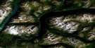
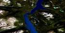
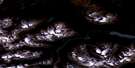
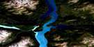
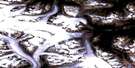
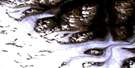
Edgar Lake Satellite Image Map
Download Free Aerial Photo 104M08 at 1:50,000 scale
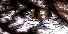
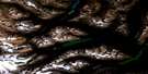
Edgar Lake Satellite Imagery
To view this satellite map, mouse over the air photo on the right.
You can also download this satellite image map for free:
104M08 Edgar Lake high-resolution satellite image map.
Maps for the Edgar Lake aerial map sheet 104M08 at 1:50,000 scale are also available in these versions:
Edgar Lake Surrounding Area Aerial Photo Maps
 |
 |
 |
 |
 |
 |
 |
 |
 |
 |
 |
|
 |
 |
© Department of Natural Resources Canada. All rights reserved.
Edgar Lake Gazetteer
The following places can be found on satellite image map 104M08 Edgar Lake:
Edgar Lake Satellite Image: Bays
Taku ArmWillison Bay
Edgar Lake Satellite Image: Capes
Willison PointEdgar Lake Satellite Image: Channels
Torres ChannelEdgar Lake Satellite Image: Glaciers
Alcove GlacierBalcony Glacier
Cathedral Glacier
Chapel Glacier
Coliseum Glacier
Snowslide Glacier
Edgar Lake Satellite Image: Islands
Copper IslandEdgar Lake Satellite Image: Lakes
Atlin LakeEdgar Lake
Nelson Lake
Tagish Lake
Edgar Lake Satellite Image: Mountains
Boundary RangesChaîne Côtière
Coast Mountains
Engineer Mountain
Florence Mountains
Florence Range
Gleaner Mountain
Mount Cameron
Mount Edward Little
Mount Switzer
Splinter Peak
Tagish Highland
The Cathedral
White Moose Mountain
Edgar Lake Satellite Image: Conservation areas
Atlin ParkEdgar Lake Satellite Image: Rivers
Buchan CreekButler Creek
Cathedral Creek
Chapel Creek
Chicken Creek
Coliseum Creek
Hale Creek
Plateau Creek
Section Creek
Swanson River
Wann River
Willison Creek
Edgar Lake Satellite Image: Unincorporated areas
Ben-My-ChreeEngineer

© Department of Natural Resources Canada. All rights reserved.
