St Bride's Topo Map Online
Download Free Topo Map Sheet 001L16 at 1:50,000 scale
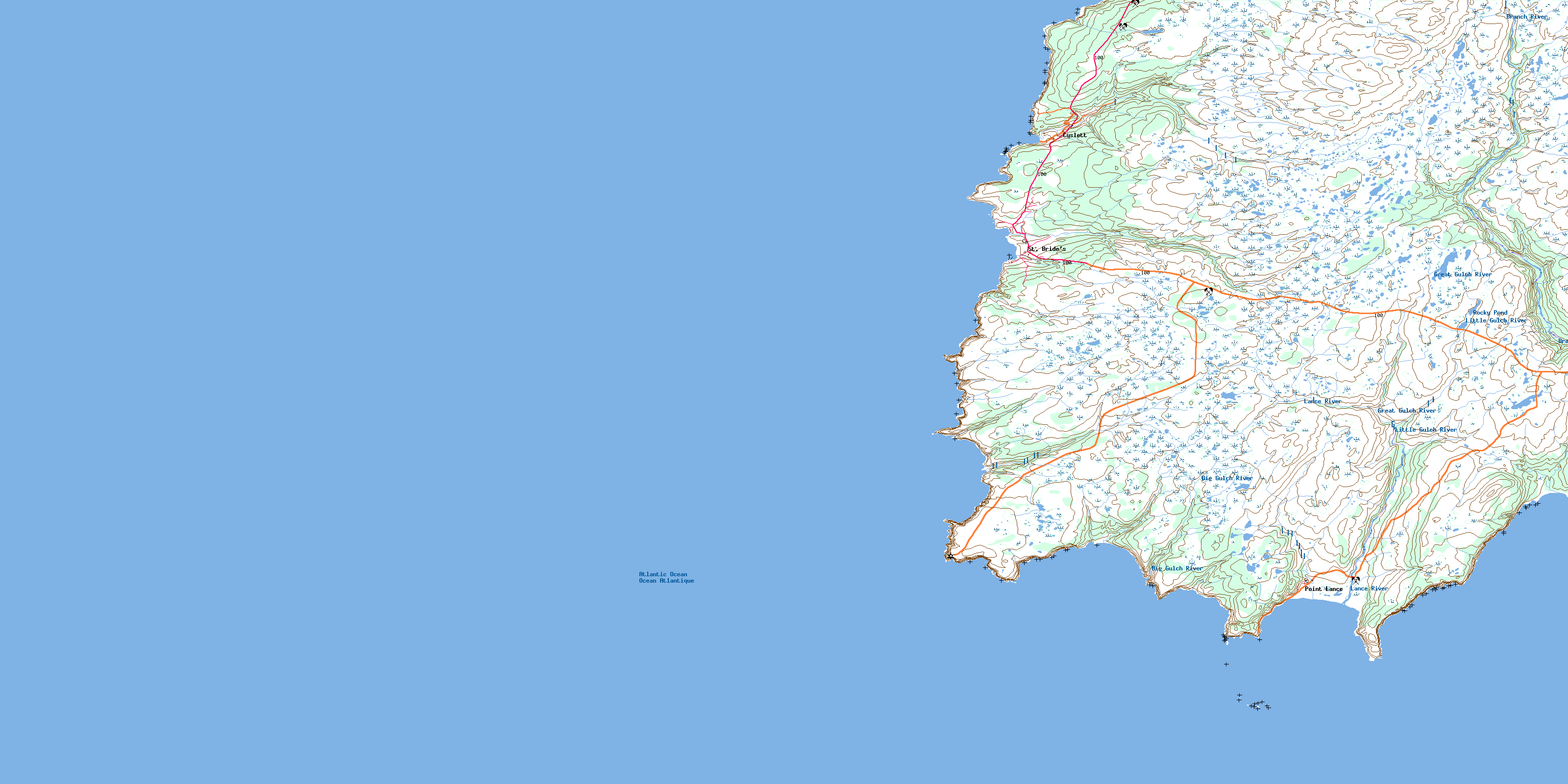
001L16 St Bride's Topo Map
To view this map, mouse over the map preview on the right.
You can also download this topo map for free:
001L16 St Bride's high-resolution topo map image.
Maps for the St Bride's topo map sheet 001L16 at 1:50,000 scale are also available in these versions:
St Bride's Surrounding Area Topo Maps
 |
 |
 |
|
© Department of Natural Resources Canada. All rights reserved.
St Bride's Gazetteer
The following places can be found on topographic map sheet 001L16 St Bride's:
St Bride's Topo Map: Bays
Big Island CoveBig Island Head Cove
Brierly Cove
Brook of Water
Bull Cove
Bull Island Cove
Butchers Cove
Cape Cove
Caplin Cove
Cats Cove
Corner Cove
Cross Point Cove
Cuslett Cove
Deadmans Cove
Distress Cove
Downeys Dock
False Cape Cove
Fish Cove
Fish Hole
Golden Bay
Grandfather
Gull Cove
Hurricane Cove
Ladder Cove
Lance Cove
Lears Cove
Little Island Head Cove
Northern Head Cove
Otter Rub
Outside Cove
Outside Cove
Perch Cove
Placentia Bay
Point Breme Cove
Redland Cove
Shag Roost
St. Mary's Bay
The Roost
Tom Conways Cove
Watering Cove
Wester Cove
Wild Cove
Wreck Cove
St Bride's Topo Map: Beaches
Cape ShoreCuslett Beach
Golden Bay Beach
Gull Cove Strand
Patty Powers Dock
Point Lance Sands
St Bride's Topo Map: Capes
Avalon PeninsulaBig Head
Black Point
Breme Point
Brierly Point
Bull Island Point
Bull Point
Cape St. Mary's
Cat Cove Point
Chimney
Cross Point
Cuslett Point
False Cape
Flagstaff
Golden Bay Point
Gun Point
Hurricane Point
Island Head
Juggys Point
Lears Cove Point
Little Island Head
Norther Head
Point Breme
Point Lance
Redland Point
Shoal Point
Wreck Cove Point
St Bride's Topo Map: Channels
Bull Island GutSt Bride's Topo Map: Cliffs
Bill of The CapeCahoons Cliff
Inside Scrape
Outside Scrape
Western Cliff
St Bride's Topo Map: Forests
The Frenchmans WoodsSt Bride's Topo Map: Islands
False CayMolly Island
St Bride's Topo Map: Lakes
Bank of Snow PondBig Gulch Gully
Big Gulch Pond
Big Pond
Black Hummock Pond
Carbrace Pond
Goose Pond
Green Hills Ponds
Little Gulch Pond
Long Pond
Rocky Pond
Rocky Pond
Valleys Pond
St Bride's Topo Map: Mountains
Big HillBlack Hummock Hill
Burnt Hill
Dry Ridge
Golden Bay Lookout
Green Hills
Gull Cove Hill
Pinnacle
Platform Hills
Redland
St. Bride's Lookout
The Whales Back
Willy Hummock
St Bride's Topo Map: Conservation areas
Cape St. Mary's Ecological ReserveCape St. Mary's Seabird Ecological Reserve
St Bride's Topo Map: Rivers
Angels Cove BrookBig Brook
Big Gulch River
Black Hummock Gully
Black Spruce Gully
Branch Gully
Branch River
Bucket River
Burnt Hill River
Cape Brook
Conways Brook
Cuslett Brook
Distress River
East Brook
Golden Bay Brook
Great Gulch
Great Gulch River
Green Hill Brook
Gull Cove River
Inside Gully
Iron Kean Brook
Island Head River
Lance River
Lears Cove River
Little Gulch
Little Gulch River
Muskrat Brook
North Bucket River
Norther Head River
Outside Gully
Powers Gully
Redland River
River of Rum
South Brook
St. Bride's Brook
Three Rivers
St Bride's Topo Map: River features
Three Rivers PointSt Bride's Topo Map: Shoals
Bird IslandBull and Cow
Bull Island
Cow and Calf Bull
Cuslett Rock
Delaney Rock
Lance Rock
Nest Rock
Perch Rock
St. Mary's Cays
The Sunker
St Bride's Topo Map: Towns
Point LanceSt. Bride's
St Bride's Topo Map: Unincorporated areas
Cape St. Mary'sCuslett
Lears Cove
Tilts
© Department of Natural Resources Canada. All rights reserved.
