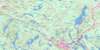
Mount Uniacke Topo Map Online
Download Free Topo Map Sheet 011D13 at 1:50,000 scale
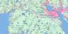
011D13 Mount Uniacke Topo Map
To view this map, mouse over the map preview on the right.
You can also download this topo map for free:
011D13 Mount Uniacke high-resolution topo map image.
Maps for the Mount Uniacke topo map sheet 011D13 at 1:50,000 scale are also available in these versions:
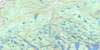
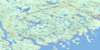
Mount Uniacke Surrounding Area Topo Maps
 |
 |
 |
 |
 |
 |
 |
|
 |
|||
© Department of Natural Resources Canada. All rights reserved.
Mount Uniacke Gazetteer
The following places can be found on topographic map sheet 011D13 Mount Uniacke:
Mount Uniacke Topo Map: Bays
Camp CoveCrane Cove
Gowans Cove
Lawrence Cove
Loon Cove
Loon Cove
Meek Arm
Melvin Cove
Mill Cove
Millers Cove
Moose Cove
Moose Horn Cove
Moosehorn Cove
Peggy Cove
Ponhook Cove
Sand Cove
Sand Cove
Sandy Cove
Shaffer Cove
Sleepy Cove
Tars Cove
Two Mile Lake Cove
Walsh Cove
Mount Uniacke Topo Map: Capes
Burnt PointCochran Point
Fishing Point
Green Point
Indian Point
Owl Head
Owls Head
Round Point
Squaw Point
Welsh Point
Mount Uniacke Topo Map: Channels
Acker NarrowsFirst Narrows
Lower Narrows
Narrows
Second Narrows
The Gullies
Upper Narrows
Upper Narrows
Mount Uniacke Topo Map: Falls
Big CascadeMount Uniacke Topo Map: Geographical areas
HalifaxHants
Mount Uniacke Topo Map: Indian Reserves
Shubenacadie 13Mount Uniacke Topo Map: Islands
Adams IslandHaverstock Island
Horse Islands
Lone Cloud Island
Ned Island
Pompeys Island
Sand Cove Island
Scout Island
Upper Pompeys Island
Mount Uniacke Topo Map: Lakes
"A" Lake15-Minute Lake
Acker Lake
Annand Lake
Anthony Lake
Ash Lake
Back Lake
Baker Lake
Barrens Pond
Barrett Lake
Bates Lake
Beaver Bank Lake
Beaver Lake
Beaver Lake
Beaver Pond
Beaver Pond
Beaver Pond
Beaver Pond
Beaverbank Lake
Beeswanger Lake
Bennery (Long) Lake
Bennery Lake
Bennett Lake
Bezanson Ponds
Big Indian Lake
Big Walsh Lake
Birch Bark Lake
Birch Lake
Black Lake
Blind Lake
Blueberry Lakes
Bog Lake
Boggy Hole
Bottle Lake
Bottle Lake
Bowsprit Lake
Brunswick Lake
Bug Lake
Cameron Lake
Chapman Lake
Christie Lake
Clarke Lake
Clay Lake
Clements Lake
Cochran Lake
Cockscomb Lake
Connor Lake
Cranberry Lake
Crotched Lake
Daley Lake
Dark Lake
Dark Lake
Deep Lake
Dick Lake
Dore Mud Pond
Drain Lake
Duck Lake
Duck Lake
Duck Pond
Duck Pond
Duck Pond
Duck Ponds
East Lake
East Moose Lake
Egg Lake
Fahey Lake
Fales Lake
Feely Lake
Fenerty Lake
Fifteen Minute Lake
First Lake
Fish Lake
Fish Lake
Fish Lake
Five Island Lake
Five Mile Lake
Fletchers Lake
Fox Lake
Frying Pan Hole
Frying Pan Lake
Fultz Lake
Golden Lake
Granite Lake
Granite Lake
Green Lake
Gunn Ponds
Hamilton Lake
Hamilton Pond
Harry Hole
Haunted Lake
Hawkin Hall Lake
Hookhorn Lake
Hoop Hole Pond
Hoop Pole Pond
Hoophole Pond
Horn Lake
Horne Lake
Horse Pond
Horse Shoe Lake
Island Lake
Island Lake
Island Lake
Jim Horne Lake
Juniper Lake
Kehoe Lake
Kelly Lake
Kelly Lake
Kelly Long Lake
King Lake
King Lake
Kinsac Lake
Knowles Lake
Lacey Lake
Lacey Mill Lake
Lagoon Lakes
Lake Fletcher
Lake Major
Lake Thomas
Lake William
Law Lake
Laws Lake
Leonard Lake
Lewis Lake
Lewis Lake
Lily Lake
Lisle Lake
Little Beeswanger Lake
Little Frying Pan Lake
Little Grand Lake
Little Indian Lake
Little Lake
Little Lake
Little Lake
Little Pockwock Lake
Little Red Trout Lake
Little Soldier Lake
Little Springfield Lake
Little Walsh Lake
Little West Lake
Littles Lake
Lizard Lake
Lizard Lake
Lizard Lake
Long Lake
Long Lake
Long Ponds
Lookout Lake
Lucky Lake
Mack Lake
Marr Lake
Marshy Lake
Mason Lake
McCabe Lake
McGrath Lake
McLennan Mill Lake
McNab Pond
Melvin Lake
Miller Lake
Moon Lake
Moore Lake
Mud Hole
Mud Lake
Mud Lake
Mud Pond
Mud Pond
Muddy Pond
Murphy Lake
Muskrat Lakes
Nash Lake
Nelson Lake
Nelson Pond
Nicholson Lake
Nix Lake
Nolan Lake
Norman Lake
North Red Trout Lake
North Uniacke Lake
Oak Lake
Oak Lake
O'Hearn Flowage
O'Hearn Lake
Peggy Pond
Peggys Pond
Pentz Lake
Percy Lake
Perry Lake
Pigott Lake
Pockwock Lake
Poor Trout Lake
Porcupine Lake
Powder Mill Lake
Preeper Big Lake
Preeper Pond
Proctor Pond
Queen Lake
Rafter Lake
Rasley Lake
Rees Lake
Reeve Lake
Rocky Lake
Rocky Lake
Rocky Lake
Rocky Lake
Round Lake
Sandford Lake
Sandy Lake
Sandy Lake
Sandy Lake
Savage Lake
Second Lake
Sheepskin Lake
Shubenacadie Grand Lake
Shubenacadie Lake
Skerry Ponds
Smiley Lake
Snowshoe Pond
Soldier Lake
Soldier Lake
South Red Trout Lake
Spectacle Lakes
Spider Lake
Spriggs Lake
Springfield Lake
Square Lake
St. Andrews Lake
Star Lake
Stinking Pond
Sullivan Lake
Taylor Lake
Third Lake
Thompson Lake
Thompson Lake
Thompson Lake
Thompson Pond
Three Mile Lake
Three Mile Lake
Tomahawk Lake
Tucker Lake
Two Mile Lake
Two Tongue Lake
Uniacke Lake
Webber Lake
Wellner Lake
West Lake
Whelan Lake
White Lake
Whites Lake
Willis Lake
Wilson Lake
Wright Lake
Wrights Lake
Yellow Lily Lake
Mount Uniacke Topo Map: Mountains
American HillArdoise Hill
Bare Hill
Blue Hill
Brushy Hill
Brushy Hill
Campbell Hill
Christie Hill
Kehoe Hill
Kehoe Mountain
Laidlaw Hill
Maroon Hill
Mount Portobello
Mount Rascal
Mount Uniacke
Nicholson Hill
Phillip Hill
Sand Cove Mountain
Sugarloaf
Target Hill
Willow Hill
Mount Uniacke Topo Map: Major municipal/district area - major agglomerations
East HantsHalifax
West Hants
Mount Uniacke Topo Map: Conservation areas
Laurie Provincial ParkMount Uniacke Provincial Park
Oakfield Provincial Park
Waverley Game Sanctuary
Waverley Salmon River Long Lake Wilderness Area
Mount Uniacke Topo Map: Rapids
Long Lake RunMount Uniacke Topo Map: Rivers
Annand BrookBaker Brook
Beaver Bank River
Beaver Brook
Beaver Pond Brook
Beaver River
Beaverbank River
Bennery Brook
Black Brook
Black Brook
Black Brook
Black Brook
Bog Brook
Box Mill Brook
Camphill Brook
Cockscomb Run
Colonels Brook
Crane Nest Brook
Culvert Brook
Dawson Brook
Drinking Hole Brook
Duck Lake Brook
Fall River
German Creek
Gibb Brook
Grassy Brook
Herbert River
Herbert River (South Branch)
Holland Brook
Holland Brook
Jarret Brook
Jarrett Brook
Johnson River
Kelly Brook
King Brook
Kings Brook
Lacey River
Little Meander River
Little Sackville River
Long Gullies
Long Lake Brook
Marr Brook
Marshall Brook
McCarthy Brook
McDowell Brook
Meadow Brook
Meadow Brook
Meander River
Melvin Brook
Mill Brook
Moore Lake Brook
Moose Brook
Nine Mile River
Ninemile River
Nix Brook
Nolan Brook
North Brook
North River
North Slough Brook
Northwest Brook
Officer Brook
O'Hearn Brook
Peggy Brook
Peggy Pond Brook
Pockwock River
Rawdon River
Rees Brook
Rocky Brook
Sackville River
Sandy Brook
Sandy Brook
Sandy Cole Brook
Sandy Lake Brook
Shubenacadie River
Skerry Brook
Slaty Brook
Soldier Lake Gullies
South Slough Brook
Sucker Brook
Tannery Brook
Thompson Run
Thompson's Run
Three Bridges Brook
Thumb Hill Creek
Tillmann Brook
Toddy Brook
Tullock Brook
Two Mile Lake Brook
Uniacke Brook
Uniacke River
Walsh Brook
Walsh Brook
Weir Brook
West Brook
Willis Brook
Mount Uniacke Topo Map: River features
Devils JawJack Stillwater
Jakes Stillwater
Jarrett Hole
Kings Deadwaters
Little Deadwaters
Long Stillwater
Long Stillwater
Melvin Brook Deadwaters
Moose Brook Deadwaters
Nicholson Stillwater
Nixon Hole
Rees Deadwater
The Ox Bow
Mount Uniacke Topo Map: Road features
The PortageMount Uniacke Topo Map: Shoals
Mile RockSalmon Rock
Mount Uniacke Topo Map: Unincorporated areas
ArdoiseAshdale
Beaver Bank
Beaver Bank Villa
Beaverbank
Beaverbank Villa
Belnan
Cameron Lake
Dawson Siding
East Uniacke
Elmsdale
Enfield
Etter Settlement
Fall River
Fall River West
Fenerty
Fenerty's
Fletchers Lake
Frenchmans Road
Grand Lake
Grand Lake Station
Green Hill
Greenhill
Groves
Hillsvale
Horne Settlement
King Station
Kinsac
Lake Thomas
Lakeland
Lakelands
Lakeview
Lewis Lake
Lewis Mills
Lochview Road
Lower Sackville
Lucasville
Maroon Hill
Middle Beaver Bank
Middle Beaverbank
Middle Sackville
Montavista
Mount Uniacke
Mount Uniacke Gold District
Mount Uniacke Gold Mines
Newport Corner
North Beaver Bank
North Beaverbank
Oakfield
Oland
Old Cobequid Road
Old Holland Road
Oldham
Pockwock
Rocky Lake
South Rawdon
South Uniacke
Springfield Lake
Steam Shovel Siding
Stillwater
Upper Hammonds Plains
Upper Newport
Upper Sackville
Waverley
Wellington
Wellington Station
Windsor Junction
Mount Uniacke Topo Map: Low vegetation
Bear SwampBlackhole Meadow
Bullmen Meadow
Bulmer Meadow
Hammonds Plains
Hay Marsh
Henry Meadow
Jakes Meadow
John Lively Meadow
Lively Meadows
MacKenzies Meadow
Mark Meadows
McDowell Bog
Nicholson Bog
Parkers Meadows
Rasley Meadow
The Slough Hole
Weedy Meadow

© Department of Natural Resources Canada. All rights reserved.
