Ecum Secum Topo Map Online
Download Free Topo Map Sheet 011D16 at 1:50,000 scale
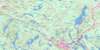
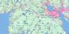
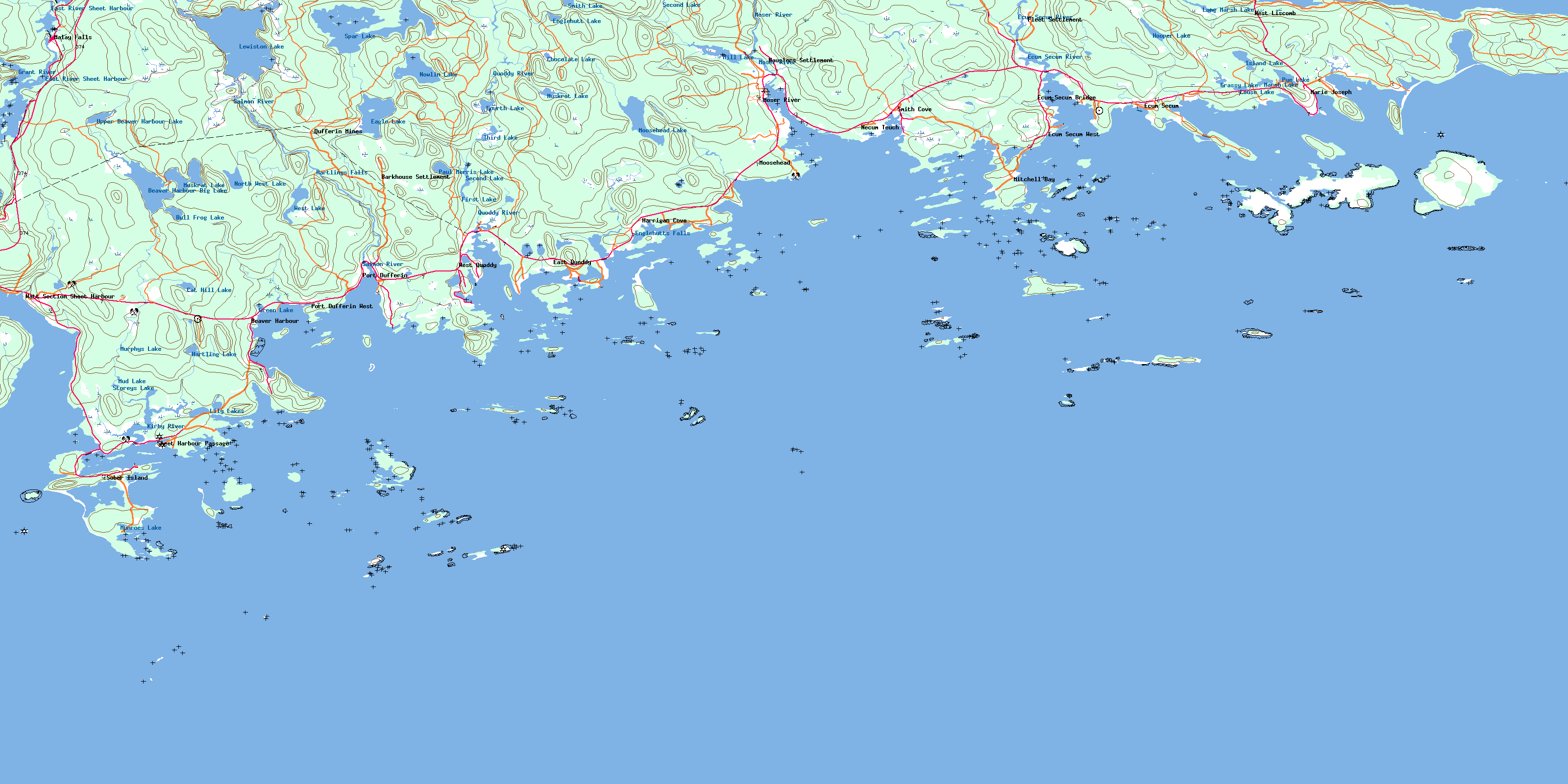
011D16 Ecum Secum Topo Map
To view this map, mouse over the map preview on the right.
You can also download this topo map for free:
011D16 Ecum Secum high-resolution topo map image.
Maps for the Ecum Secum topo map sheet 011D16 at 1:50,000 scale are also available in these versions:
Ecum Secum Surrounding Area Topo Maps
 |
 |
 |
 |
 |
 |
 |
|
 |
|||
© Department of Natural Resources Canada. All rights reserved.
Ecum Secum Gazetteer
The following places can be found on topographic map sheet 011D16 Ecum Secum:
Ecum Secum Topo Map: Bays
Alex CoveAndersons Cove
Back Bay
Back Cove
Back Cove
Baker Cove
Bay of Islands
Beaver Harbour
Betts Cove
Big Barren Cove
Black Cove
Black Duck Cove
Boat Cove
Bulls Cove
Camp Cove
Carrying Cove
Coomb Cove
Coombs Bay
Cropleys Cove
Deadmans Point
Deep Cove
Eastern Cove
Ecum Secum Harbour
Ecum Secum Inlet
Englehutts Cove
Factory Cove
Felker Cove
Frenchmans Harbour
Gammons Creek
Geddes Cove
Harrigan Cove
Hartlings Creek
Hatch Cove
Hawbolt Cove
Hawbolts Cove
Hugh John Cove
Hurd Cove
Jewer Cove
Jewers Bay
Jewers Cove
Jewers Cove
Johnnys Cove
Langilles Cove
Liscomb Harbour
MacDonalds Cove
Macleod Cove
Marie Joseph Harbour
Marsh Cove
McLeod Cove
Mitchell Bay
Moosehead Cove
Mosers Cove
Mozier Cove
Murphy Cove
Necum Teuch Bay
Necum Teuch Harbour
Paces Cove
Pond Cove
Quoddy Harbour
Quoddy Inlet
Richardsons Cove
Salmon Cove
Sam Miseners Cove
Sand Cove
Sellars Cove
Sheet Harbour
Smith Cove
Smith Cove
Smoke Point Cove
Snows Cove
Voglers Cove
Whale Cove
White Island Bay
Ecum Secum Topo Map: Beaches
Andersons Back ShoreBack Beach
Back Shore
Big Head Breakers
Bird Islands Breakers
Gerrys Beach
Half Hour Breaker
Halibut Islands Breaker
Hawbolt Beach
Little Breaker
Morris Beach
Pond Beach
Quoddy Big Breaker
Schoolhouse Beach
Ship Breaker
Southwest Breaker
Southwest Breaker
Southwest Breakers
Southwest Tuffin Breaker
Success Breaker
The Flats
Western Shagroost Breakers
Ecum Secum Topo Map: Capes
Atkins PointBarney Point
Beachgrass Head
Beaver Point
Beeswangers Point
Big Head
Blackbill Point
Blind Point
Bluff Head
Breading Point
Brimstone Head
Cameron Point
Careys Point
Church Point
Coomb Point
Coombs Point
Crooks Flying Point
Davidson Point
Dogfish Head
Eastern Red Head
Eastern Red Head
Epe Point
Factory Point
Fancys Point
Fathers Head
Fishery Point
Forges Point
Hapes Point
Hawbolt Point
Hemloes Point
Indian Point
Jake Mosers Point
Lawsons Point
Liscomb Point
Lobster Point
Long Point
Macdonald Point
MacDonalds Point
Macleod Point
Markie Point
Masons Point
McLeod Point
Middle Point
Middle Point
Mitchel Point
Mitchell Point
Moose Head
Necum Point
Net Point
Nolan Head
Nowlan Head
Olding Point
Owens Point
Oxford Point
Paces Point
Perry Point
Pot Point
Quoddy Head
Salmoneaux Point
Sand Point
Sauls Point
Seal Point
Shiers Point
Slab Point
Slab Point
Smileys Point
Smith Point
Smiths Point
Smiths Red Heads
Smoke Point
Talbots Point
The Bend
Turner Point
Turners Point
Ward Point
Watt Point
Western Head
Western Point
Western Red Head
Yellow Point
Ecum Secum Topo Map: Channels
Ball GutBulls Gut
Camp Island Gulch
False Passage
Goose Gutter
Horseshoe Run
Salmoneaux Passage
Sheet Harbour Passage
The Passage
Torpey Passage
Ecum Secum Topo Map: Cliffs
Red BankSlate Cliff
Torpey Bluff
Ecum Secum Topo Map: Falls
Englehutts FallsHartlings Falls
Kirkers Falls
Ecum Secum Topo Map: Geographical areas
GuysboroughHalifax
Ecum Secum Topo Map: Hydraulic construction
Marshall DamEcum Secum Topo Map: Islands
Amos IslandAnns Island
Balcom Island
Bald Harbour Islands
Ball Gut Island
Baptiste Island
Bar Island
Barren Island
Battery Island
Beaver Island
Berrigans Island
Big Halibut Island
Big Harbour Island
Big Island
Big Island
Big Rocky Island
Bird Islands
Black Duck Island
Black Duck Island
Boson Island
Brokenback Island
Brother Islands
Calf Island
Calf Island
Camerons Island
Camp Island
Campbell Island
Cat Cove Island
Cat Island
Charles Island
Crooks Island
Crow Island
Danbury Island
Deadman Island
Deepwater Island
East Hog Island
East Sheep Island
Eastern Shagroost
Fish Island
Fishery Island
Flag Island
Frying Pan Island
Gold Island
Goose Island
Goose Island
Goose Island
Halibut Islands
Harbour Islands
Hardwood Island
Hardwood Island
Hardwood Island
Hartlings Island
Hawbolt Island
Hawbolts Islands
Hen Island
High Island
High Island
Hog Island
Horse Island
Indian Island
Inside Eastern Harbour Island
Jacks Island
John Warrens Camp Island
Kenney Islands
Lang Island
Little Goose Island
Little Halibut Island
Little Hog Island
Little Island
Little Island
Little Island
Little Islands
Little Puncheon Island
Little Rocky Island
Little Ship Island
Little Tuffin Island
Little White Island
Lobster Island
Long Island
Long Island
Macdonald Island
Macleod Island
Marsh Island
Mary Island
Middle Halibut Island
Mink Island
Mink Island
Mink Island
Mink Island
Mink Island
Mink Island
Orkney Island
Orkney Islands
Outside Eastern Harbour Island
Pauls Island
Peter Island
Philip Island
Pig Island
Pumpkin Island
Rack Island
Rack Island
Ragged Islands
Ram Island
Rams Island
Rocky Island
Rocky Island
Round Island
Round Island
Round Island
Salmon Island
Sandy Island
Sheep Island
Sheep Island
Sheep Island
Ship Island
Slate Island
Smiths Island
Snow Island
Sober Island
Softwood Island
Speck Island
Spider Island
Stem Island
Stewarts Island
Sutherland Island
Table Island
The Finger
The Pancake
The Turnip Patch
Thrumcap Island
Tidmarsh Island
Tomahawk Island
Torpey Island
Tuffin Island
Turner Island
Turner Island
Turners Island
Voglers Island
Western Shagroost
Westhavers Island
White Islands
Wreck Island
Ecum Secum Topo Map: Lakes
Beaver Harbour Big LakeBlackberry Pond
Bull Frog Lake
Bulls Pond
Cat Hill Lake
Chocolate Lake
Eagle Hunt Lake
Eagle Lake
East Lake
East River Sheet Harbour (Reservoir)
Englehutt Lake
Fancys Pond
First Lake
Fourth Lake
Gammons Pond
Goose Pond
Grassy Lake
Green Lake
Halfway Brook Lake
Hartling Lake
Hartlings Pond
Hooper Lake
Island Lake
Kirkers Pond
Lang Pond
Langs Pond
Lewiston Lake
Lily Lake
Lily Lakes
Lily Pond
Lily Pond
Little Beaver Lake
Long Marsh Lake
Louse Lake
Malay Falls Flowage
Marsh Lake
Marshall Flowage
Mill Lake
Moosehead Lake
Moser Pond
Mud Lake
Munroes Lake
Murphys Lake
Muskrat Lake
Muskrat Lake
North West Lake
Nowlin Lake
Paul Morris Lake
Pug Hole
Pye Lake
Ruth Falls Flowage
Salmon River Big Lake
Salmon River Lake
Saltwater Pond
Second Lake
Second Lake
Shiers Pond
Smith Lake
Sober Island Pond
Spar Lake
Storeys Lake
The Barachois
The Gullies
Third Lake
Toms Pond
Upper Beaver Harbour Lake
West Lake
West Lake
Ecum Secum Topo Map: Mountains
Blackberry HillMoose Hill
Quoddy Hill
Ecum Secum Topo Map: Major municipal/district area - major agglomerations
HalifaxSt. Mary's
Ecum Secum Topo Map: Conservation areas
Eastern Shore Islands Wildlife Management AreaMarie Joseph Provincial Park
Ecum Secum Topo Map: Rivers
Bear BrookEast River Sheet Harbour
East River Sheet Harbour
Ecum Secum River
Eel Brook
Grant River
Halfway Brook
Kirby River
Mill Brook
Moosehead Brook
Moser River
Northeast Brook
Pye Brook
Quoddy River
Rocky Brook
Salmon River
Salmon River
Smelt Brook
Smith Brook
West Branch Salmon River
West Brook
Ecum Secum Topo Map: River features
Alder Island StillwaterBranch Basin
Bridge Pool
Clarkes Dam Pool
Clay Bank Pool
East Brook Pool
Footbridge Pool
Granite Rock Pool
Hartlings Falls Pool
Lower Falls Pool
Nauglers Stillwater
Salmon Hole
Slaughterhouse Pool
The Bridges Pool
Upper Falls Pool
Upper Salmon Hole
West Brook Pool
Ecum Secum Topo Map: Shoals
Babin ShoalBad Luck Shoal
Balcom Shoal
Ballast Shoal
Barney Ledge
Bassoon Reefs
Beachgrass Head Rock
Beacon Ledges
Beaver Tail
Big Shoal
Big Shoal
Big Shoal
Big Shoal
Bird Shoals
Black Bull
Black Ledge
Black Peg
Black Peg Shoal
Black Rock
Bobs Rock
Bowen Ledge
Bowens Ledge
Bowens Rock
Bull Rock
Bushy Ledge
Byrne Rock
Calf Island Shoal
Calf Shoal
Camp Island Ledge
Chapel Shoal
Coral Shoal
Crab Rock
Crackerbone
Crazy Kate
Crooks Rock
Daves Rock
David Shoal
Dogfish Ledge
Dry Ledge
Dry Ledge
Dry Shoal
Duck Rock
Duck Rock
Duck Shoals
East Black Ledge
Epe Rock
Frenchman Rock
Frenchmans Rock
Gander Rock
Geddes Shoal
Georges Mark
Goose Island Ledges
Grassy Ledge
Gravelly Ledge
Gull Ledge
Gull Ledge
Gull Rock
Gull Rock
Gunning Rock
Gunning Rocks
Halibut Islands Ledge
Hapes Rock
Harbour Islands Ledges
Harbour Rock
Harbour Rock
Harbour Rock
Hard Shoal
Hardwood Island Reef
Hardwood Island Shoal
Harvey Shoal
Hatch Cove Shoal
Hawes Shoal
Hen and Chickens
Herring Hole
High Island Ledges
High Ledges
Horse Island Ledge
Horse Island Rock
Horse Shoal
Horseshoe Shoal
Horseshoe Shoal
Howes Marsh Shoal
Hubbub Rock
Inside Middle Grounds
John Spot
Kitts Reef
Langs Ledges
Ledge Rocks
Little Bull
Lockwood Rock
Logan Rock
MacCarthys Clam Bank
MacDonald Rock
Macdonald Rock
Macdonald Shoals
MacDonalds Rock
MacDonalds Shoals
Mad Moll Rock
Marmot Rock
Middle Ground
Middle Ground
Middle Ground
Middle Ground
Middle Grounds
Middle Shoal
Middle Shoal
Middle Shoal
Mitchell Ledge
Monroe Rock
Moser Rock
Nags Head
Net Rock
Nightcap Ledge
Nowlans Shoal
Nowlans Shoal
O'Learys Rock
Outside Middle Grounds
Pan Shoal
Pancake Shoal
Perry Shoal
Point Spot
Pollock Shoal
Pollock Shoal
Pumpkin Island Ledges
Pumpkin Rock
Quoddy Shoals
Roaring Cow
Rocky Point
Round Island Ledge
Salamander Rock
Sam Ground
Sammys Shoal
Sams Ground
Sand Shoal
Sand Shoal
Sandy Island Shoal
Seal Ledge
Seal Ledges
Seal Rocks
Seal Rocks
Seal Rocks
Shag Ledge
Shag Rock
Sheet Rock
Sheet Rock
Siteman Rock
Slab Shoal
Smith Rock
Snapper Shoal
Speck Ledge
Steering Ledge
Sugarloaf
Sunken Rock
Table Island Reefs
The Bar
The Bassoon
The Blazes
The Brothers
The Frenchman
The Frenchman
The Gardens
The Hubbub
The Ledge
The Ledges
The Moll
The Nightcap
The Whalesback
Thorne Shoal
Thrumcap Shoal
Tuffin Ledges
Tuffin Shoal
Turner Shoal
Turner Shoal
Turners Shoal
West Black Ledge
West Rock
Western Middle Grounds
Western Pumpkin Reef
Western Rocks
Whale Rock
White Cliffs
White Rock
White Shoal
White Shoal
Whitman Ledge
William Shoal
Williams Reef
Worths Rock
Yankee Jack
Ecum Secum Topo Map: Unincorporated areas
Barkhouse SettlementBeaver Harbour
Dufferin Mines
East Quoddy
Ecum Secum
Ecum Secum Bridge
Ecum Secum West
Fleet Settlement
Harrigan Cove
Hartling
Malay Falls
Marie Joseph
Mitchell Bay
Moosehead
Moser River
Mosers River
Nauglers Settlement
Necum Teuch
Pace Settlement
Port Dufferin
Port Dufferin West
Sheet Harbour Passage
Smith Cove
Sober Island
Watt Section
Watt Section Sheet Harbour
West Liscomb
West Newdy Quoddy
West Quoddy
Ecum Secum Topo Map: Low vegetation
Floating BogHowes Marsh
Muir Pond Bog
© Department of Natural Resources Canada. All rights reserved.
