White Cloud Island Topo Map Online
Download Free Topo Map Sheet 041A15 at 1:50,000 scale
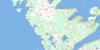
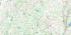
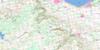
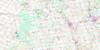
041A15 White Cloud Island Topo Map
To view this map, mouse over the map preview on the right.
You can also download this topo map for free:
041A15 White Cloud Island high-resolution topo map image.
Maps for the White Cloud Island topo map sheet 041A15 at 1:50,000 scale are also available in these versions:
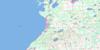
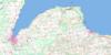
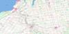
White Cloud Island Surrounding Area Topo Maps
 |
 |
 |
|
 |
 |
 |
|
 |
 |
 |
 |
 |
 |
 |
 |
© Department of Natural Resources Canada. All rights reserved.
White Cloud Island Gazetteer
The following places can be found on topographic map sheet 041A15 White Cloud Island:
White Cloud Island Topo Map: Bays
Baie GeorgienneBig Bay
Colpoy Bay
Colpoys Bay
Colpoy's Bay
Cove of Cork
Cove of Cork Bay
Georgian Bay
Kidd Bay
North Bay
White Cloud Island Topo Map: Capes
Bruce PeninsulaCameron Point
Cape Commodore
Cape Croker
Cornet Point
Deepwater Point
Kidd Point
North Point
South Point
White Cloud Island Topo Map: Cliffs
Esther CliffEsther's Bluff
Patterson Cliffs
White Cloud Island Topo Map: Geographical areas
AlbemarleBruce
Keppel
White Cloud Island Topo Map: Indian Reserves
Cape Croker Indian Reserve 27Neyaashiinigmiing Indian Reserve 27
Réserve indienne Cape Croker 27
Réserve indienne Neyaashiinigmiing 27
White Cloud Island Topo Map: Islands
Griffith IslandHay Island
White Cloud Island
White Cloud Island Topo Map: Lakes
Lac HuronLake Huron
Slough of Despond
White Cloud Island Topo Map: Mountains
Dodds HillHalliday Hill
Skinner Bluff
Skinner's Bluff
White Cloud Island Topo Map: Major municipal/district area - major agglomerations
BruceGrey
White Cloud Island Topo Map: Other municipal/district area - miscellaneous
AlbemarleAmabel
Derby
Georgian Bluffs
Keppel
Sarawak
White Cloud Island Topo Map: Rivers
Big Bay CreekWhite Cloud Island Topo Map: Shoals
Thirty Fathom BankTwelve Fathom Bank
White Cloud Island Topo Map: Towns
South Bruce PeninsulaWhite Cloud Island Topo Map: Unincorporated areas
Big BayMakataewaukawauk
North Keppel
© Department of Natural Resources Canada. All rights reserved.
