Iosegun Lake Topo Map Online
Download Free Topo Map Sheet 083K07 at 1:50,000 scale
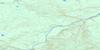
083K07 Iosegun Lake Topo Map
To view this map, mouse over the map preview on the right.
You can also download this topo map for free:
083K07 Iosegun Lake high-resolution topo map image.
Maps for the Iosegun Lake topo map sheet 083K07 at 1:50,000 scale are also available in these versions:
Iosegun Lake Surrounding Area Topo Maps
 |
 |
 |
 |
 |
 |
 |
 |
 |
 |
 |
 |
 |
 |
 |
 |
© Department of Natural Resources Canada. All rights reserved.
Iosegun Lake Gazetteer
The following places can be found on topographic map sheet 083K07 Iosegun Lake:
Iosegun Lake Topo Map: Lakes
Clark LakeIosegun Lake
Raspberry Lake
Smoke Lake
Iosegun Lake Topo Map: Major municipal/district area - major agglomerations
Municipal District of Greenview No. 16Iosegun Lake Topo Map: Rivers
Heavysound CreekIosegun River
Little Smoky River
Pass Creek
Iosegun Lake Topo Map: Towns
Fox CreekIosegun Lake Topo Map: Unincorporated areas
Iosegun LakeKaybob
© Department of Natural Resources Canada. All rights reserved.
083K Related Maps:
083K Iosegun Lake083K01 Windfall Creek
083K02 Marsh Head Creek
083K03 Berland River
083K04 No Title
083K05 Deep Valley Creek
083K06 Tony Creek
083K07 Iosegun Lake
083K08 Two Creek
083K09 No Title
083K10 Atikkamek Creek
083K11 Waskahigan River
083K12 Ante Creek
083K13 Long Lake
083K14 Asplund Creek
083K15 Sweathouse Creek
083K16 Wallace River
