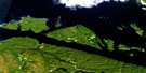
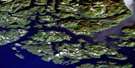
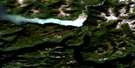
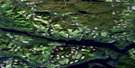
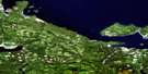
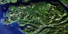
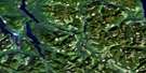
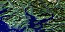
Brooks Peninsula Satellite Image Map
Download Free Aerial Photo 092L04 at 1:50,000 scale
Brooks Peninsula Satellite Imagery
To view this satellite map, mouse over the air photo on the right.
You can also download this satellite image map for free:
092L04 Brooks Peninsula high-resolution satellite image map.
Maps for the Brooks Peninsula aerial map sheet 092L04 at 1:50,000 scale are also available in these versions:
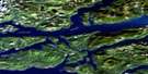
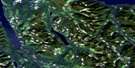
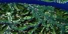
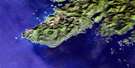
Brooks Peninsula Surrounding Area Aerial Photo Maps
 |
 |
 |
 |
 |
 |
 |
 |
 |
 |
 |
 |
 |
 |
 |
 |
© Department of Natural Resources Canada. All rights reserved.
Brooks Peninsula Gazetteer
The following places can be found on satellite image map 092L04 Brooks Peninsula:
Brooks Peninsula Satellite Image: Bays
Ambrosia BayAster Bay
Battle Bay
Brooks Bay
Checleset Bay
Columbia Cove
Drift Whale Bay
Guilliams Bay
Hackett Bay
Klaskish Anchorage
Klaskish Inlet
Nasparti Inlet
Brooks Peninsula Satellite Image: Capes
Acous PeninsulaBrooks Peninsula
Cape Cook
Cautious Point
Clerke Point
Green Head
Izard Point
Jackobson Point
Lorenz Point
Mahope Point
Orchard Point
Pinnacle Point
Sapir Point
Theodore Point
Brooks Peninsula Satellite Image: Channels
Gay PassageBrooks Peninsula Satellite Image: Indian Reserves
Acous Indian Reserve 1Checkaklis Island Indian Reserve 9
Hub-toul Indian Reserve 2A
Klaskish Indian Reserve 3
Mahope Indian Reserve 3
Quin-e-ex Indian Reserve 8
Réserve indienne Acous 1
Réserve indienne Checkaklis Island 9
Réserve indienne Hub-toul 2A
Réserve indienne Klaskish 3
Réserve indienne Mahope 3
Réserve indienne Quin-e-ex 8
Réserve indienne Upsowis 6
Upsowis Indian Reserve 6
Brooks Peninsula Satellite Image: Islands
Barrier IslandsBonner Islet
Bunsby Islands
Checkaklis Island
Clara Islet
Clerke Islet
Crabapple Islets
Cuttle Islets
Donald Islets
Guilliams Island
Hackett Island
Hat Island
McDougal Island
O'Leary Islets
Scarf Island
Shelter Island
Skirmish Islets
Solander Island
The Haystacks
Vancouver Island
Yule Island
Brooks Peninsula Satellite Image: Lakes
Andromeda LakeCanoe Lake
Cape Cook Lagoon
Cassiope Pond
Cladothamnus Lake
Drosera Lake
Empetrum Lake
Gaultheria Lake
Gentiana Lake
Johnson Lagoon
Kalmia Lake
Ledum Lake
Loiseleuria Lake
Menziesia Lake
Moneses Lake
Oxycoccus Lake
Phyllodoce Lake
Pyrola Lake
Vaccinium Lake
Brooks Peninsula Satellite Image: Mountains
Button PeakByers Cone
Doom Mountain
Harris Peak
Lagoon Peak
Mount Seaton
Nunatak Mountain
Ragged Cone
Refugium Range
Saxifraga Mountain
Shields Cone
Vancouver Island Mountains
Vancouver Island Ranges
Brooks Peninsula Satellite Image: Major municipal/district area - major agglomerations
Regional District of Comox-StrathconaRegional District of Mount Waddington
Brooks Peninsula Satellite Image: Conservation areas
Big Bunsby Marine ParkBig Bunsby Park
Brooks Peninsula Park
Brooks Peninsula Recreation Area
Brooks Peninsula Satellite Image: Rivers
Amos CreekAmos River
Canoe Creek
Cladothamnus Creek
East Creek
Gold Creek
Harris Creek
Kalmia Creek
Kingfisher Creek
Marks Creek
Menziesia Creek
Nordstrom Creek
Romanzoffia Creek
Scramble Creek
Brooks Peninsula Satellite Image: Shoals
Baker RockBanks Reef
Boit Rock
Clerke Reefs
Cutler Rock
East Rock
Eldridge Rock
Fairway Rock
Ferey Rock
Longback Rocks
McKiel Rock
Mile Rock
Quineex Reef
Sulivan Reefs
Yule Rock

© Department of Natural Resources Canada. All rights reserved.
092L Related Maps:
092L Alert Bay092L01 Schoen Lake
092L02 Woss Lake
092L03 Kyuquot
092L04 Brooks Peninsula
092L05 Mahatta Creek
092L06 Alice Lake
092L07 Nimpkish
092L08 Adam River
092L09 Minstrel Island
092L10 Alert Bay
092L11 Port Mcneill
092L12 Quatsino
092L13 Shushartie
092L14 Bradley Lagoon
092L15 Broughton Island
092L16 Kingcome Inlet
