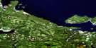
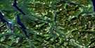
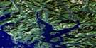
Mahatta Creek Satellite Image Map
Download Free Aerial Photo 092L05 at 1:50,000 scale
Mahatta Creek Satellite Imagery
To view this satellite map, mouse over the air photo on the right.
You can also download this satellite image map for free:
092L05 Mahatta Creek high-resolution satellite image map.
Maps for the Mahatta Creek aerial map sheet 092L05 at 1:50,000 scale are also available in these versions:
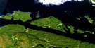
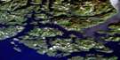
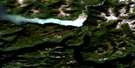
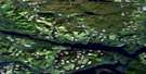
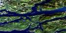
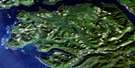
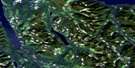
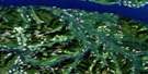
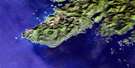
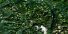
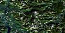
Mahatta Creek Surrounding Area Aerial Photo Maps
 |
 |
 |
 |
 |
 |
 |
 |
 |
 |
 |
 |
 |
 |
 |
 |
© Department of Natural Resources Canada. All rights reserved.
Mahatta Creek Gazetteer
The following places can be found on satellite image map 092L05 Mahatta Creek:
Mahatta Creek Satellite Image: Bays
Brooks BayEast Cove
Gooding Cove
Harvey Cove
Julian Cove
Klaskino Anchorage
Klaskino Inlet
Klaskish Basin
Koprino Harbour
Koskimo Bay
Kultus Cove
Neroutsos Inlet
Nordstrom Cove
Quatsino Sound
Restless Bight
Shapland Cove
Side Bay
Smith Cove
Mahatta Creek Satellite Image: Capes
Banter PointCliffe Point
Heater Point
Holloway Point
Kwakiutl Point
Langsdorff Point
Lawn Point
Lyons Point
May Point
Mocino Point
Pender Point
Prideaux Point
Mahatta Creek Satellite Image: Channels
Buchholz ChannelNewton Entrance
Scouler Entrance
Mahatta Creek Satellite Image: Indian Reserves
Clatux Indian Reserve 9Mah-te-nicht Indian Reserve 8
Réserve indienne Clatux 9
Réserve indienne Mah-te-nicht 8
Réserve indienne Teeta 7
Réserve indienne Telaise 1
Réserve indienne Tsowenachs 2
Teeta Indian Reserve 7
Telaise 1
Telaise Indian Reserve 1
Tsowenachs 2
Tsowenachs Indian Reserve 2
Mahatta Creek Satellite Image: Islands
Anchorage IslandBedwell Islands
Bland Island
Botel Islet
Brockton Island
Chapman Islet
Drake Island
Farmer Islets
Gillam Islands
Half Moon Islets
Keefe Island
Koskimo Islands
Lind Islet
Lyons Islet
Mabbott Island
Mayday Island
McAllister Islet
Norgar Islet
Rugged Islands
Salmon Islands
Schloss Island
Vancouver Island
Mahatta Creek Satellite Image: Lakes
Botel LakeLe Mare Lake
O'Connell Lake
Mahatta Creek Satellite Image: Mountains
Carter PeakComstock Mountain
McKay Ridge
Mount Bury
Mount Clark
Mount Kotzebue
Mount Pickering
Mount Wolfenden
Nose Peak
Red Stripe Mountain
Restless Mountain
Sieward Hill
Vancouver Island Mountains
Vancouver Island Ranges
Yaky Kop Cone
Mahatta Creek Satellite Image: Major municipal/district area - major agglomerations
Regional District of Mount WaddingtonMahatta Creek Satellite Image: Conservation areas
Kwakiutl/Lawn Point ParkLawn Point Park
Quatsino Park
Mahatta Creek Satellite Image: Rivers
Blumberg CreekBuchholz Rock
Buck Creek
Cayuse Creek
Cleagh Creek
Colonial Creek
Coqueis Creek
Culleet Creek
Debris Creek
East Creek
Goquaw Creek
Head Creek
Julian Creek
Keith River
Kewquodie Creek
Klaskish River
Klootchlimmis Creek
Koskimo Creek
Mahatta Creek
Mahwhieclas Creek
Monkey Creek
Montgomery Creek
Power River
Sequodie Creek
Skidine Creek
Teeta Creek
Mahatta Creek Satellite Image: Shoals
Billard RockBrown Rock
Gould Rock
Hughes Rock
Martin Rock
Monday Rocks
Morris Rocks
Noot Rock
Pilley Shoal
Pilling Rock
Rowley Reefs
Scarf Reef
Steele Reefs
Mahatta Creek Satellite Image: Unincorporated areas
Mahatta RiverYreka
Mahatta Creek Satellite Image: Valleys
Scouler Pass
© Department of Natural Resources Canada. All rights reserved.
092L Related Maps:
092L Alert Bay092L01 Schoen Lake
092L02 Woss Lake
092L03 Kyuquot
092L04 Brooks Peninsula
092L05 Mahatta Creek
092L06 Alice Lake
092L07 Nimpkish
092L08 Adam River
092L09 Minstrel Island
092L10 Alert Bay
092L11 Port Mcneill
092L12 Quatsino
092L13 Shushartie
092L14 Bradley Lagoon
092L15 Broughton Island
092L16 Kingcome Inlet
