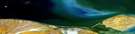
Glacier Creek Satellite Image Map
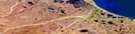
Download Free Aerial Photo 117D04 at 1:50,000 scale
Glacier Creek Satellite Imagery
To view this satellite map, mouse over the air photo on the right.
You can also download this satellite image map for free:
117D04 Glacier Creek high-resolution satellite image map.
Maps for the Glacier Creek aerial map sheet 117D04 at 1:50,000 scale are also available in these versions:
Glacier Creek Surrounding Area Aerial Photo Maps
 |
|||
 |
 |
||
 |
 |
 |
 |
© Department of Natural Resources Canada. All rights reserved.
Glacier Creek Gazetteer
The following places can be found on satellite image map 117D04 Glacier Creek:
Glacier Creek Satellite Image: Mountains
British MountainsBuckland Hills
Buckland Range
Glacier Creek Satellite Image: Conservation areas
Ivvavik National Park of CanadaParc national du Canada Ivvavik
Glacier Creek Satellite Image: Rivers
Camping CreekCanyon Creek
Firth River
Glacier Creek
Spring River
Tulugaq River

© Department of Natural Resources Canada. All rights reserved.
