Tusket Topo Map Online
Download Free Topo Map Sheet 020P13 at 1:50,000 scale
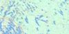
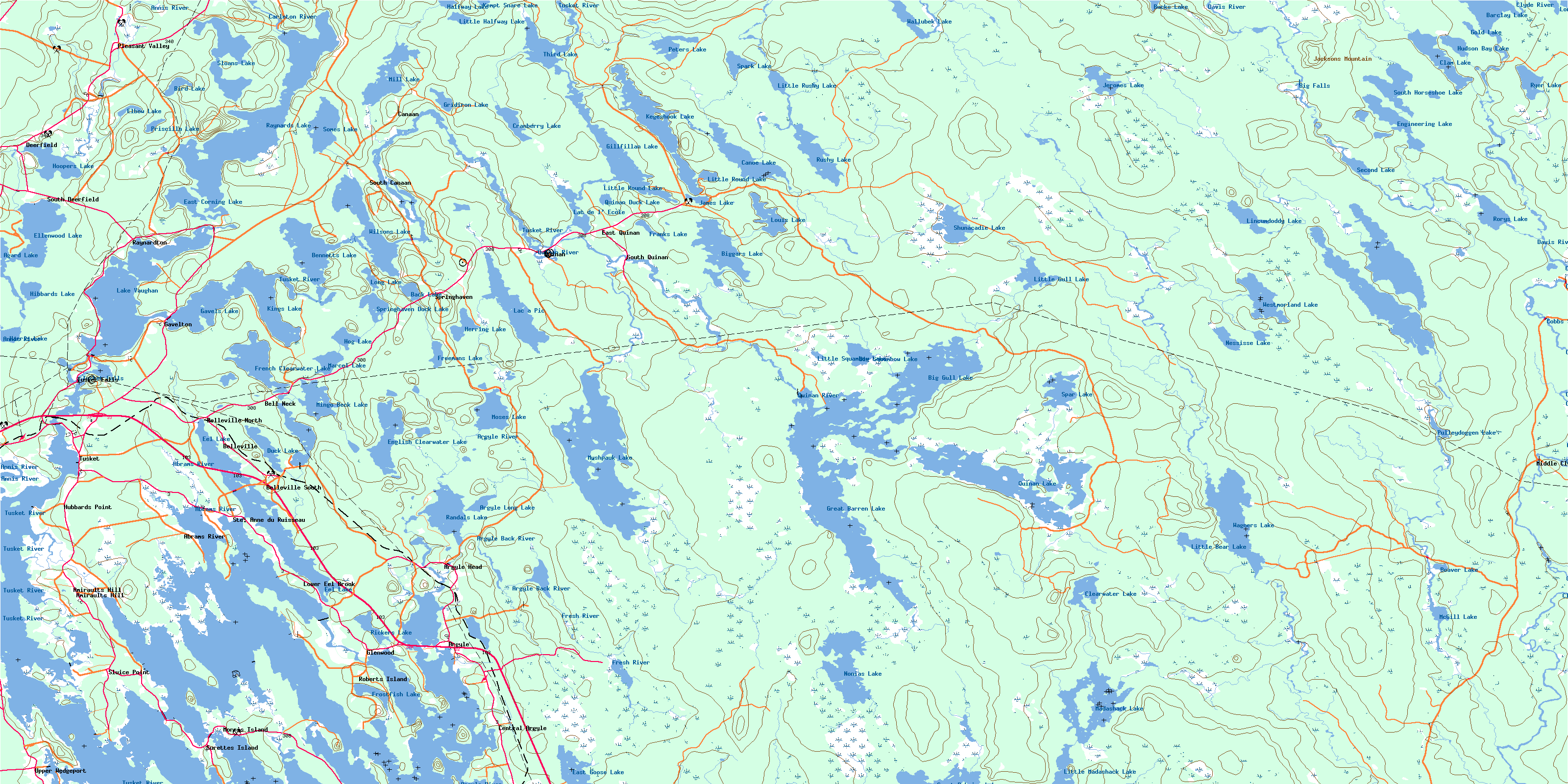
020P13 Tusket Topo Map
To view this map, mouse over the map preview on the right.
You can also download this topo map for free:
020P13 Tusket high-resolution topo map image.
Maps for the Tusket topo map sheet 020P13 at 1:50,000 scale are also available in these versions:
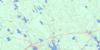
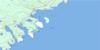
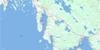
Tusket Surrounding Area Topo Maps
 |
 |
 |
|
 |
 |
||
 |
 |
||
© Department of Natural Resources Canada. All rights reserved.
Tusket Gazetteer
The following places can be found on topographic map sheet 020P13 Tusket:
Tusket Topo Map: Bays
Bourques CoveBurke Cove
Chebeck Cove
Glenwood Bay
Horse Creek
Indian Bay
Indian Sluice Bay
Kenny Cove
Roberts Anchorage
Salt Bay
The Basin
Vacons Cove
Tusket Topo Map: Capes
Arnold PointBeach Point
Brandy Point
Burrills Point
Crowell Point
Far Point
Fox Point
Fox Point
Green Point
High Head
Hubbards Point
Indian Point
Long Point
McKinnon Neck
Moodys Point
Moose Point
Muises Point
Northwest Point
Rocco Point
Sluice Point
Tête à Milie
Vacons Point
Websters Point
Wedgeport Cape
Tusket Topo Map: Channels
Big SluiceCrazy Pass
Eastern River
Indian Sluice
La Grande Passe
Little Sluice
The Bar
The Narrows
The Narrows
The Narrows
The Sluice
Tusket Topo Map: Falls
Bad FallsBig Falls
Carrying Falls
Cobbs Scutch Falls
Eel Weir Falls
Franks Falls
Gridiron Falls
Grid-iron Falls
Hemlock Falls
Indian Falls
Long Falls
Longs Falls
Martin Falls
Middle Clyde Falls
Middle Falls
Moodys Falls
Nickersons Falls
Old Bridge Falls
Potomac Falls
Rocky Creek Falls
Slate Falls
Snows Falls
Trap Falls
Tree Falls
Trout Hole Falls
Tusket Falls
Wilsons Falls
Tusket Topo Map: Geographical areas
ShelburneYarmouth
Tusket Topo Map: Hydraulic construction
Abbotts DykeTusket Topo Map: Islands
Big IslandBills Island
Birch Island
Birch Island
Birch Island
Bourques Island
Briar Island
Butter Island
Calf Island
Cat Island
Cornelius Island
Devils Island
Dyes Island
Eagle Island
Ensors Island
Far Point Island
Far-point Island
Flick Island
Fox Island
Gunning Island
Hare Island
Harts Island
Hay Islands
Little Calf Island
Maple Island
Meeting Island
Mike Island
Mikes Island
Mikes Little Island
Morris Island
Pitmans Island
Pothiers Island
Rabbit Island
Ram Islands
Roberts Island
Ryders Island
Slokums Island
Smith Island
Squires Island
Surettes Island
Tinkhams Island
Upper Frost Island
Widgegum Islands
Tusket Topo Map: Lakes
Agard LakeArgyle Long Lake
Back Lake
Bannockburn Pond
Barclay Lake
Barren Lake
Beaver Lake
Beaver Pond
Bennet Lake
Bennets Lake
Bennetts Lake
Big Gull Lake
Big Squambow Lake
Biggars Lake
Bigger Lake
Bird Lake
Bloody Lake
Bucks Lake
Butler Lake
Butler Lake
CanoeLake
Carleton Lake
Clam Lake
Clearwater Lake
Clearwater Lake
Clyde River Beaver Pond
Cocos Pond
Cranberry Lake
Crane Lake
Currys Pond
Currys Ponds
Duck Lake
Duck Pond
Duck Pond
East Corning Lake
East Goose Lake
Eastern Duck Pond
Eds Ponds
Eel Lake
Elbow Lake
Ellenwood Lake
Engineering Lake
English Clearwater Lake
Franks Lake
Freemans Lake
French Clearwater Lake
Frost Lake
Frostfish Lake
Frost-fish Lake
Frosts Pond
Gavel Lake
Gavels Lake
Gilfilling Lake
Gillfillan Lake
Gold Lake
Great Barren Lake
Great Barren Lake Flowage
Great Pubnico Lake
Gridiron Lake
Gull Lake
Halfway Lake
Harris Lake
Herring Lake
Hibbards Lake
Hibbert Lake
Hog Lake
Hooper Lake
Hoopers Lake
Hudson Bay Lake
James Lake
Jeromes Lake
Joes Pond
Kegeshook Lake
Kempt Snare Lake
Kings Lake
Lac à Pic
Lac de l'École
Lake Vaughan
Lincumdoddy Lake
Little Bear Lake
Little Gull Lake
Little Halfway Lake
Little Lake
Little Madashack Lake
Little Round Lake
Little Round Lake
Little Rushy Lake
Little Rushy Lake
Little Squambow Lake
Loch An Duach
Loch Dutch
Lochan Duach
Long Lake
Long Lake
Louis Lake
Madashack Lake
Marcel Lake
McGill Lake
Mespark Lake
Mickchickchawagata Lakes
Mikchickche-chewagatha Lakes
Mikchik Lakes
Mill Lake
Mingo Beck Lake
Moses Hill Ponds
Moses Lake
Mushpauk Lake
Naustaush Pond
Nessisse Lake
Nonias Lake
Northern Duck Ponds
Pats Scooping Place
Peter Lake
Peters Lake
Pothiers Millpond
Priscilla Lake
Pulldozen Lake
Pulleydoggen Lake
Quinan Duck Lake
Quinan Lake
Randal Lake
Randals Lake
Raynards Lake
Raynardton Beaver Pond
Ricker Lake
Rickers Lake
Rory Lake
Rorys Lake
Rushy Lake
Ryer Lake
Salter Lake
Sand Pond
Second Lake
Shunacadie Lake
Sloan Lake
Sloans Lake
Snare Lake
Somes Lake
South Clearwater Lake
South Horseshoe Lake
Spar Lake
Spark Lake
Springhaven Duck Lake
Third Lake
Turtle Pond
Vaughan Lake
Wagners Lake
Wallubek Lake
West Clearwater Lake
Western Duck Pond
Westmore Lake
Westmorland Lake
Wilsons Lake
Tusket Topo Map: Mountains
Goodwins RidgeJacksons Mountain
Kiahs Hill
Moses Hill
North Roberts Hill
Roberts Hill
Spar Ridge
Spinney Hill
Tusket Topo Map: Major municipal/district area - major agglomerations
ArgyleBarrington
Shelburne
Yarmouth
Tusket Topo Map: Conservation areas
Ellenwood Lake Provincial ParkGlenwood Provincial Park
Réserve nationale de faune de Sand Pond
Sand Pond National Wildlife Area
Tusket Topo Map: Rapids
Franks EddyIndian Eddy
Peters Rapids
The Branch Shoals
The Guaygus
The Horserace
Tusket Topo Map: Rivers
Abram RiverAbrams River
Absaloms Run
Annis River
Argyle Back River
Argyle River
Back River Brook
Bannockburn Brook
Bearden Brook
Beaver Brook
Big Falls Brook
Birch Hill Creek
Birch Run
Bloody Creek
Bog Brook
Campbells Hill Brook
Carleton River
Cavanaghs Run
Clearwater Lake Brook
Clyde River
Cold Stream
Cranberry Brook
Davis River
Duck Brook
East River
Engineering Lake Brook
Fresh River
Hamilton Branch
Hamilton Creek
Harper Creek
Hills Meadow Brook
Kiack Brook
Lincumdoddy Brook
Little Bear Lake Brook
Mushpauk Brook
Nonias Lake Brook
Northwest Branch
Pats Meadow Brook
Peters Brook
Porcupine Brook
Potter Run Brook
Potters Run
Quinan River
Roaring Brook
Rocky Creek
Salmon Creek
Shunacadie Brook
Silver River
Spar Brook
Squambow Brook
Trout Hole Brook
Tusket River
Welchards Brook
Tusket Topo Map: River features
Goudeys StillwaterNaustaush Eel Pot
Old Mill Stillwater
The Billy Hole
The Trout Hole
Tusket Topo Map: Shoals
Bar RockGunning Ledge
Quinan Meat Rock
Tusket Topo Map: Unincorporated areas
Abram RiverAbrams River
Amirault Hill
Amiraults Hill
Argyle
Argyle
Argyle Head
Bell Neck
Belleville
Belleville North
Belleville South
Brazil Lake
Canaan
Central Argyle
Crosby
Deerfield
East Quinan
Eel Brook
Gavelton
Glenwood
Hubbard Point
Hubbards Point
Lower Eel Brook
Middle Clyde River
Morris Island
Pleasant Valley
Pleasant Valley Corner
Quinan
Raynardton
Reynard Bridge
Reynardton
Roberts Island
Sluice Point
South Canaan
South Deerfield
South Quinan
Springhaven
Ste. Anne du Ruisseau
Surette Island
Surettes Island
Tusket
Tusket Falls
Upper Wedgeport
Tusket Topo Map: Low vegetation
Coffin MeadowCroshes Meadow
Gavels Meadow
Goose Heath
Great Heath
Hills Meadow
Pats Meadow
Spinneys Heath
Sturgess Bog
© Department of Natural Resources Canada. All rights reserved.
