Church Point Topo Map Online
Download Free Topo Map Sheet 021B08 at 1:50,000 scale
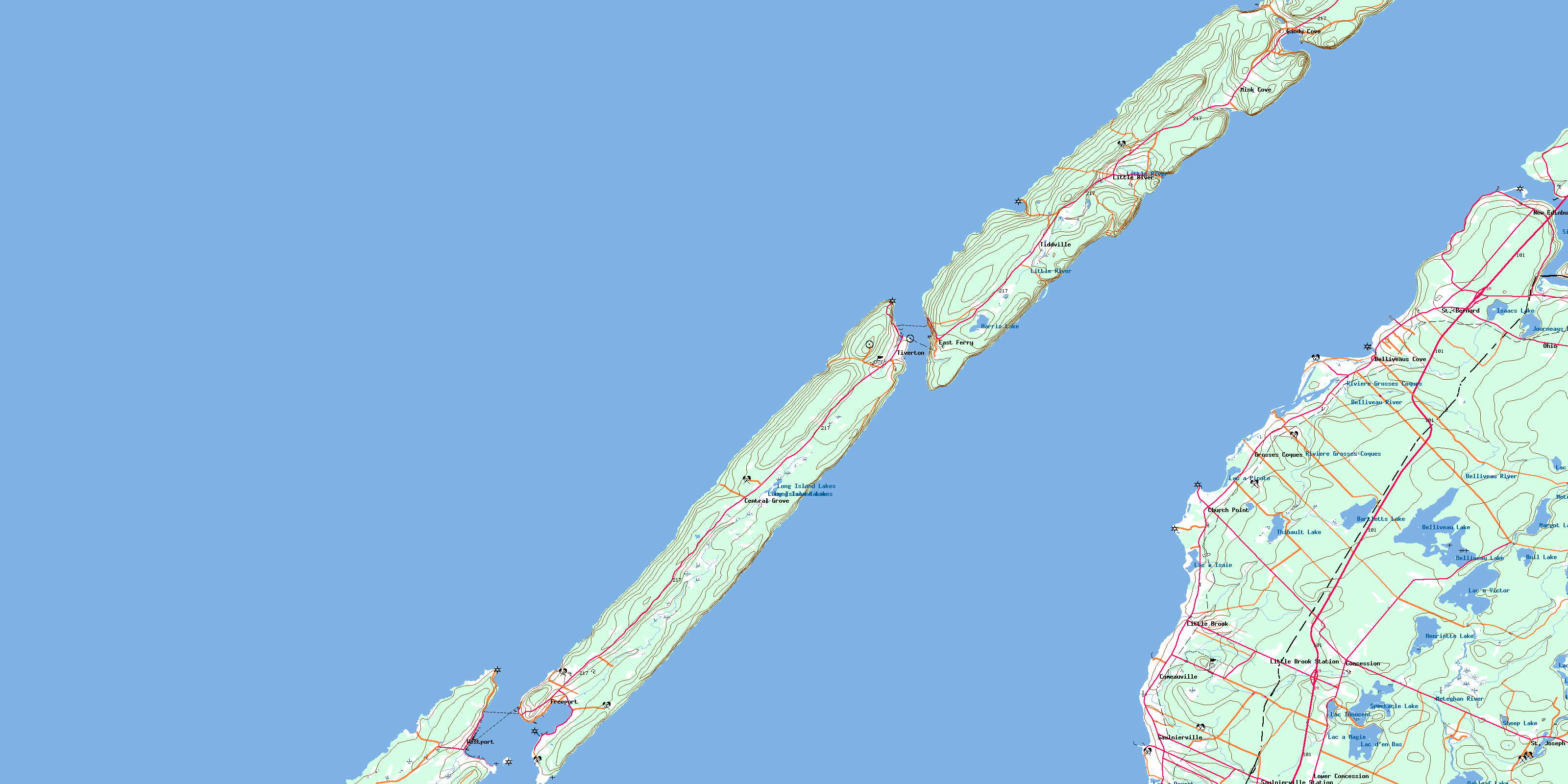
021B08 Church Point Topo Map
To view this map, mouse over the map preview on the right.
You can also download this topo map for free:
021B08 Church Point high-resolution topo map image.
Maps for the Church Point topo map sheet 021B08 at 1:50,000 scale are also available in these versions:
Church Point Surrounding Area Topo Maps
 |
|||
 |
 |
||
 |
|||
 |
© Department of Natural Resources Canada. All rights reserved.
Church Point Gazetteer
The following places can be found on topographic map sheet 021B08 Church Point:
Church Point Topo Map: Bays
Alder CoveAnse des LeBlanc
Anse des Leblanc
Baie de Fundy
Bay of Fundy
Beach Cove
Bear Cove
Beautiful Cove
Belliveau Cove
Belliveaus Cove
Belliveaus Cove
Big Cove
Canns Cove
Cardys Cove
Cow Cove
Crique des Grosses Coques
Crowells Cove
Dunnings Cove
Dyke Cove
East Sandy Cove
Flour Cove
Flower Cove
Gooseberry Cove
Grahams Cove
Grand Passage Lighthouse Cove
Lighthouse Cove
Little Bear Cove
Little River Cove
Mink Cove
Morris Cove
Northeast Cove
Pero Jack Cove
Pleasant Bay
Plumb Cove
Porcupine Cove
Sandy Cove
Scattering Cove
Seal Cove
St. Mary Bay
St. Marys Bay
St. Mary's Bay
Strickland Cove
Sweetcake Cove
T.R.'s Cove
Ticken Cove
Tide Pond Cove
West Mink Cove
Westport Harbour
Weymouth Harbour
Whale Cove
Whites Cove
Church Point Topo Map: Beaches
Barre à Church PointBarre à Doucet
French Beach
Lighthouse Beach
Long Beach
Tommys Beach
Church Point Topo Map: Capes
Birch PointBoars Head
Boar's Head
Burns Point
Cape Firmain
Cherry Valley Head
Church Point
Dartmouth Point
Digby Neck
Eastern Head
Flour Cove Point
Flower Cove Point
Fort Point
French Beach Point
Grand Eddy Point
Green Head
Michels Point
North Point
Northern Point
Pointe à Major
Ronnies Point
Sabean Point
Sand Point
Second Point
South Point
Western Head
Whites Point
Church Point Topo Map: Channels
Grand PassagePetit Passage
Church Point Topo Map: Cliffs
Harris BluffChurch Point Topo Map: Geographical areas
DigbyChurch Point Topo Map: Islands
Brier IslandLong Island
Peter Island
Church Point Topo Map: Lakes
Bartlet LakeBartletts Lake
Belliveau Lake
Bull Lake
Harris Lake
Henriette Lake
Isaacs Lake
Jib Lake
Journeay Lake
Journeays Lake
Lac à Doucet
Lac à Isaïe
Lac à Magie
Lac à Picote
Lac à Victor
Lac Bayou
Lac d'en Bas
Lac des Bardeaux
Lac des Castors
Lac Innocent
Long Beach Pond
Long Island Lakes
Margot Lake
Meteghan Lake
Mink Cove Pond
North Doucette Lake
Oakleaf Lake
Sheep Lake
Spectacle Lake
Spectacle Lakes
The Barachois
Thibault Lake
Youngs Lake
Church Point Topo Map: Marine navigation features
Bourneufs WharfChurch Point Topo Map: Mountains
North MountainChurch Point Topo Map: Major municipal/district area - major agglomerations
ClareDigby
Church Point Topo Map: Conservation areas
Central Grove Provincial ParkChurch Point Topo Map: Rapids
Grand EddyChurch Point Topo Map: Rivers
Belliveau RiverCampsite Brook
Freshwater Stream
Gidneys Brook
Isaacs Lake Brook
Journeays Brook
Leblanc Brook
Little Brook
Little River
Long Island Brook
Meteghan River
Rivière Grosses Coques
Rocky Brook
Ruisseau des Boudreau
Sissiboo River
Spectacle Brook
Stoney Brook
T.R.'s Brook
Thibault Brook
Weavers Brook
Church Point Topo Map: Sea features
Northwest RipChurch Point Topo Map: Shoals
Bald RockBeatson Rocks
Cow Ledge
Cow Ledge Shoal
Featherings Reef
Frenchmans Elbow
Frenchman's Elbow
John Rices Shoal
Middle Shoal
Moore Ledge
Moores Ledge
Northwest Ledge
Northwest Rock
Passage Shoal
Round Rock
St. Marys Bay Shoal
Sunken Rocks
Church Point Topo Map: Unincorporated areas
BelliveauBelliveau Cove
Belliveaus Cove
Central Grove
Church Point
Church Point Station
Comeauville
Concession
East Ferry
Gilberts Landing
Grosses Coques
Little Brook
Little Brook Station
Little River
Lower Concession
Mink Cove
New Edinburgh
Ohio
Sandy Cove
Saulnierville
Saulnierville Station
St. Bernard
St. Joseph
Tiddville
Weaver Settlement
Church Point Topo Map: Valleys
Cherry ValleyChurch Point Topo Map: Low vegetation
Marais des Grosses CoquesChurch Point Topo Map: Villages
FreeportTiverton
Westport
Weymouth
© Department of Natural Resources Canada. All rights reserved.
