Wellington Topo Map Online
Download Free Topo Map Sheet 030N14 at 1:50,000 scale
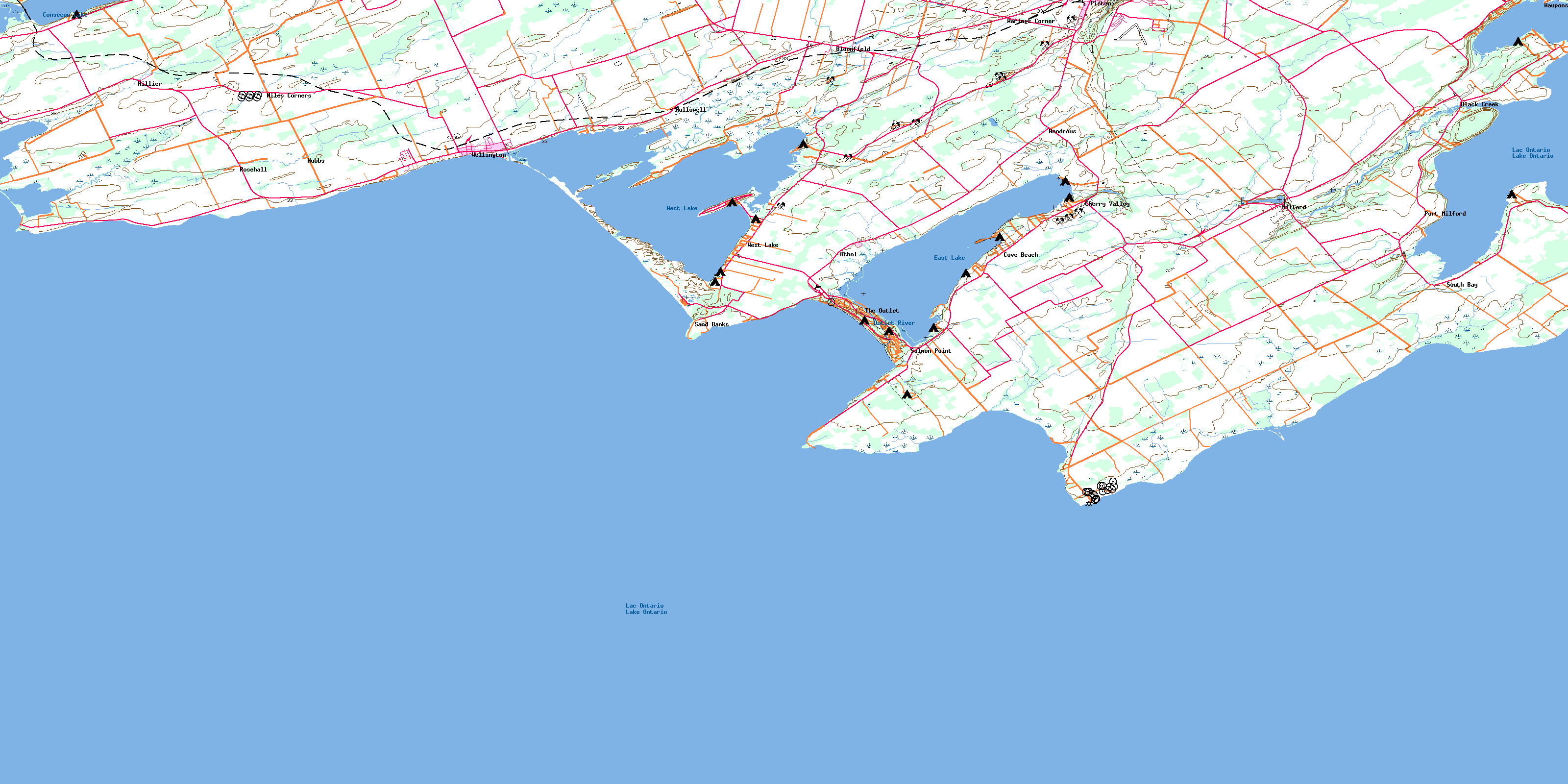
030N14 Wellington Topo Map
To view this map, mouse over the map preview on the right.
You can also download this topo map for free:
030N14 Wellington high-resolution topo map image.
Maps for the Wellington topo map sheet 030N14 at 1:50,000 scale are also available in these versions:
Wellington Surrounding Area Topo Maps
 |
 |
 |
|
© Department of Natural Resources Canada. All rights reserved.
Wellington Gazetteer
The following places can be found on topographic map sheet 030N14 Wellington:
Wellington Topo Map: Bays
Athol BayFlakes Cove
Gull Pond
Halfmoon Bay
Huyck Bay
Huycks Bay
Pleasant Bay
Prince Edward Bay
Smith Bay
Soup Harbour
South Bay
Wellington Bay
Wellington Topo Map: Beaches
Gull BarPetticoat Bar
Wellington Topo Map: Capes
Charwell PointFlatt Point
Grenade Point
Hawthorn Point
Huyck Point
Huycks Point
Owen Point
Petticoat Point
Pickerel Point
Point Petre
Salmon Point
Spencer Point
Van Dousens Point
West Point
Wicked Point
Wellington Topo Map: City
Prince EdwardWellington Topo Map: Geographical areas
AmeliasburghAthol
Hallowell
Hillier
Marysburgh
North Marysburgh
Prince Edward
South Marysburgh
Wellington Topo Map: Islands
Cat IslandGarratt Island
Gasket Island
Hickory Island
Hickory Islands
Jobs Island
Johnston Island
Parr Island
Poplar Island
Sheba's Island
Tubbs Island
Wellington Topo Map: Lakes
Bloomfield Mill PondConsecon Lake
East Lake
Lac Ontario
Lake Ontario
Mill Pond
West Lake
Wellington Topo Map: Mountains
McMahon BluffWellington Topo Map: Other municipal/district area - miscellaneous
AmeliasburghAthol
Hallowell
Hillier
Marysburgh
North Marysburgh
Sophiasburgh
South Marysburgh
Wellington Topo Map: Conservation areas
Beaver Meadow Conservation AreaMacaulay Mountain Conservation Area
Milford Mill Pond Conservation Area
Sandbanks Provincial Park
Wellington Topo Map: Rivers
Black CreekBlack River
Bloomfield Creek
Hubbs Creek
Marsh Creek
Outlet River
Wellington Topo Map: Shoals
McFaul ShoalPalen Bank
The Sandbanks
Wicked Bank
Wellington Topo Map: Unincorporated areas
AtholBlack Creek
Black River Bridge
Bloomfield
Cherry Valley
Cove Beach
Hallowell
Hillcrest
Hillier
Hubbs
Milford
Niles Corners
Outlet
Picton
Point Petre
Port Milford
Rosehall
Salmon Point
Sand Banks
South Bay
The Outlet
Warings Corner
Waupoos
Wellington
West Lake
Woodrous
© Department of Natural Resources Canada. All rights reserved.
