Consecon Topo Map Online
Download Free Topo Map Sheet 030N13 at 1:50,000 scale
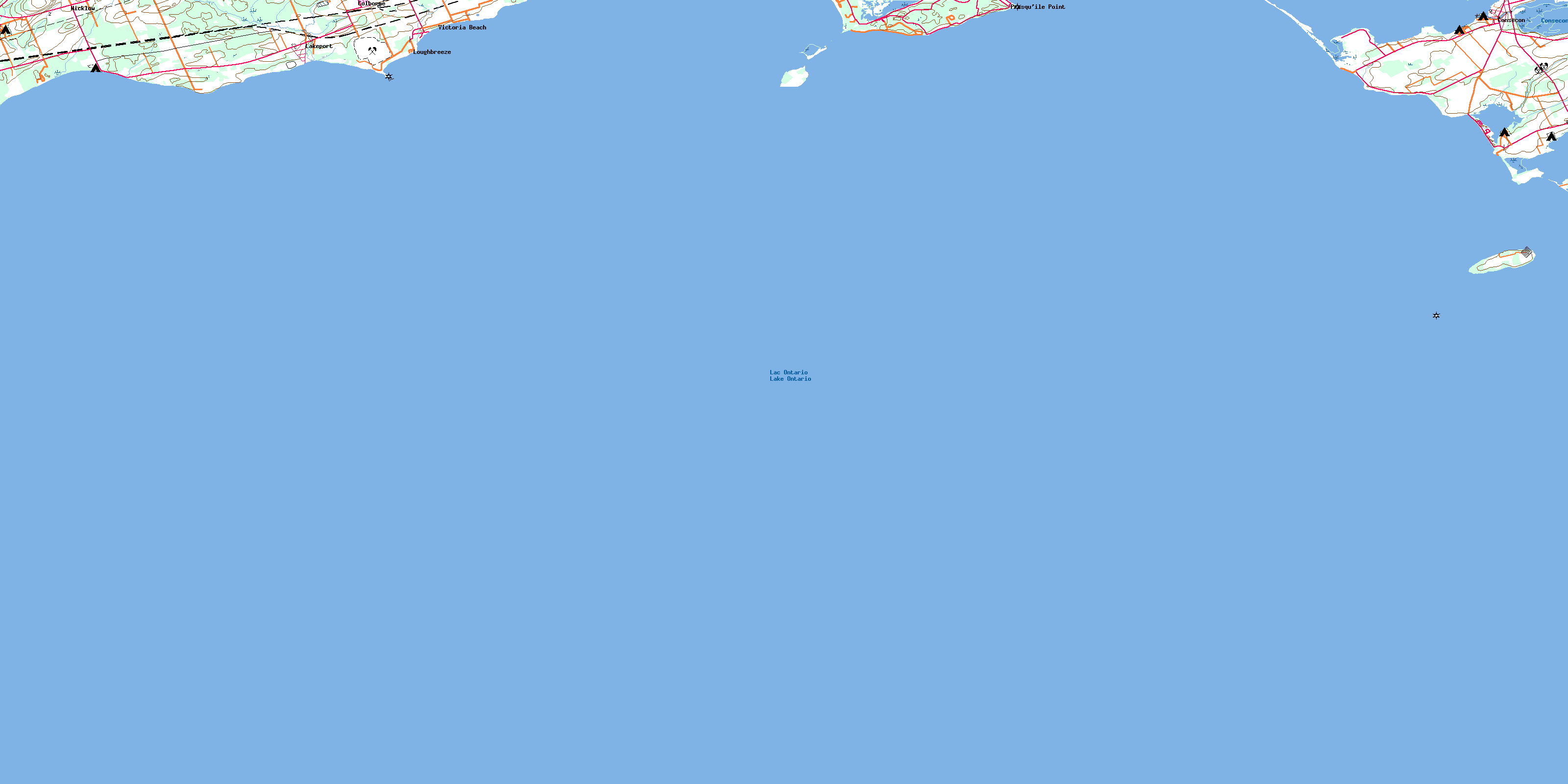
030N13 Consecon Topo Map
To view this map, mouse over the map preview on the right.
You can also download this topo map for free:
030N13 Consecon high-resolution topo map image.
Maps for the Consecon topo map sheet 030N13 at 1:50,000 scale are also available in these versions:
Consecon Surrounding Area Topo Maps
 |
 |
 |
|
© Department of Natural Resources Canada. All rights reserved.
Consecon Gazetteer
The following places can be found on topographic map sheet 030N13 Consecon:
Consecon Topo Map: Bays
North BayPleasant Bay
Popham Bay
Presqu'ile Bay
Wellers Bay
Consecon Topo Map: Beaches
Bald Head BeachVictoria Beach
Consecon Topo Map: Capes
Chatterton PointIsland Point
McGlennon Point
Ogden Point
Owen Point
Pierson Point
Point Field
Presqu'ile Peninsula
Presqu'ile Point
Proctor Point
Robinson Point
Sebastopol Point
Snider Point
Consecon Topo Map: City
Prince EdwardConsecon Topo Map: Geographical areas
AmeliasburghCramahe
Haldimand
Murray
Northumberland
Prince Edward
Consecon Topo Map: Hydraulic construction
Consecon Mill DamConsecon Topo Map: Islands
Cranberry IslandGull Island
High Bluff Island
Nicholson Island
Scotch Bonnet Island
Consecon Topo Map: Lakes
Consecon LakeLac Ontario
Lake Ontario
Consecon Topo Map: Mountains
The BluffConsecon Topo Map: Major municipal/district area - major agglomerations
NorthumberlandConsecon Topo Map: Other municipal/district area - miscellaneous
AlnwickAlnwick/Haldimand
Ameliasburgh
Athol
Brighton
Cramahe
Haldimand
Hallowell
Hillier
Marysburgh
North Marysburgh
Sophiasburgh
South Marysburgh
Consecon Topo Map: Conservation areas
Haldimand Conservation AreaNorth Beach Provincial Park
Presqu'ile Islands Wilderness Area
Presqu'ile Provincial Park
Réserve nationale de faune de la Baie-Wellers
Réserve nationale de faune de l'Île-Scotch-Bonnet
Scotch Bonnet Island National Wildlife Area
Wellers Bay National Wildlife Area
Whitney Memorial Dam Conservation Area
Consecon Topo Map: Rivers
Colborne CreekShelter Valley Brook
Shelter Valley Creek
Consecon Topo Map: Shoals
Camel ShoalCollier Shoal
Dobbs Bank
Gore Shoal
Moira Shoal
Mulcaster Patch
Nettey Patch
Palen Bank
Quick Shoal
Scotch Bonnet Shoal
Consecon Topo Map: Towns
BrightonConsecon Topo Map: Unincorporated areas
ColborneConsecon
Lakeport
Loughbreeze
Presqu'ile Point
Victoria Beach
Wicklow
Wicklow Station
© Department of Natural Resources Canada. All rights reserved.
