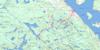
Cobalt Topo Map Online
Download Free Topo Map Sheet 031M05 at 1:50,000 scale
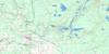
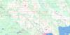
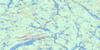
031M05 Cobalt Topo Map
To view this map, mouse over the map preview on the right.
You can also download this topo map for free:
031M05 Cobalt high-resolution topo map image.
Maps for the Cobalt topo map sheet 031M05 at 1:50,000 scale are also available in these versions:
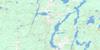
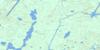
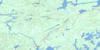
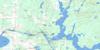
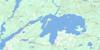
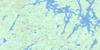
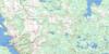
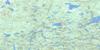
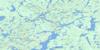
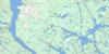
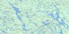
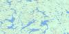
Cobalt Surrounding Area Topo Maps
 |
 |
 |
 |
 |
 |
 |
 |
 |
 |
 |
 |
 |
 |
 |
 |
© Department of Natural Resources Canada. All rights reserved.
Cobalt Gazetteer
The following places can be found on topographic map sheet 031M05 Cobalt:
Cobalt Topo Map: Bays
Baie des TiesBaie du Nord
Black Bay
Brigstocke Bay
Burnt Bay
Contact Bay
Crowrock Bay
Gilchrist Bay
Marsh Bay
Martineau Bay
Paradis Bay
Portage Bay
Sucker Gut Bay
The Boot Leg
Wabi Bay
Windy Arm
Cobalt Topo Map: Capes
Booming Out PointBurnt Point
Dawson Point
Diabase Point
Jumbo Point
Pointe Brown
Pointe Piché
Redpine Point
You-go I-go Point
Cobalt Topo Map: Channels
Second NarrowsThe Narrows
Cobalt Topo Map: City
Temiskaming ShoresCobalt Topo Map: Cliffs
Devil RockSilver Cliff
Cobalt Topo Map: Falls
Fountain FallsHigh Falls
Hound Chute
Ragged Chute
Redpine Chutes
Watson Falls
Cobalt Topo Map: Geographical areas
BarrBrigstocke
Bucke
Coleman
Dymond
Firstbrook
Gillies Limit
Harris
Hudson
Kittson
Lorrain
Lundy
Timiskaming
Cobalt Topo Map: Hydraulic construction
Latchford DamMattawapika Dam
Cobalt Topo Map: Islands
Corkill IslandDynamite Island
Farr Island
Fiddler's Island
Greenstone Island
Île Brisseau
Île Brûlée
Île Bryson
Île du Collège
Île du Finlandais
Île Mann
Île Oster
Snake Island
Sugarloaf Island
Twin Islands
Cobalt Topo Map: Lakes
Aleck's PondAnderson Lake
Anima Nipissing Lake
Barth Lake
Bartle Lake
Bass Lake
Bay Lake
Belle Isle Lake
Best Lake
Blanche Lake
Blueberry Lake
Borden Lake
Botha Lake
Bouck Lake
Bowers Lake
Brady Lake
Brief Lake
Brigstocke Lake
Bryan Lake
Cart Lake
Cassidy Lake
Charlotte Lake
Chopin Lake
Chown Lake
Clear Lake
Cobalt Lake
Coleman Lake
Columbus Lake
Conglomerate Lake
Constance Lake
Crosswise Lake
Cyril Lake
Darwin Lake
Divide Lake
Edison Lake
Edwards Lake
Eisen Lake
Expanse Lake
First Justin Lake
Firstbrook Lake
Fraleck's Pond
Frog Lake
George Lake
Gillies Lake
Giroux Lake
Gleeson Lake
Glen Lake
Goodwin Lake
Graham Lake
Grassy Lake
Green Lake
Gullrock Lake
Hammond Lake
Harris Lake
Head Lake
Hearst Lake
Hermann Pond
Hidden Lake
High Falls Lake
Hound Chute Lake
Hudfir Lake
Ibsen Pond
Ice Chisel Lake
Island Lake
Isobar Lake
Joachim Lake
Johnson Lake
Justin Lake
Kelvin Lake
Kerr Lake
Kirk Lake
Kitt Lake
Kittson Lake
Lac Gillies
Lac LeMoyne
Lac Témiscamingue
Lac Témiscamingue
Lake Timiskaming
Larabie Lake
Latour Lake
Le Heup Lake
Le Moyne Lake
Leconte Lake
Little Black Lake
Little Blueberry Lake
Little Gillies Lake
Little Grassy Lake
Little Sharp Lake
Long Lake
Longfellow Lake
Loon Lake
Maggie Lake
Mahon Lake
Malcolm Lake
Mary Ann Lake
Mayfair Pond
McLaren Lake
McLennon Lake
Moffat Lake
Moose Lake
Mowat Lake
Mud Lake
New Lake
Nicol Lake
North Beaver Lake
North Pickerel Lake
Number Six Lake
Pan Lake
Peterson Lake
Pike Lake
Pine Lake
Pretty Lake
Professor Pond
Prud'homme Lake
Raede Lake
Reid Lake
Rib Lake
Roosevelt Lake
Rousseau Lake
Saltlick Lake
Sasaginaga Lake
Schumann Lake
Second Justin Lake
Sharp Lake
Short Lake
Silver Lake
Slate Lake
Sonny Lake
South Beaver Lake
South Coleman Lake
South Pickerel Lake
Spring Lake
Starr's Pond
Stewart Lake
Straight Lake
Suddie Lake
Summit Lake
Taylor Lake
Third Justin Lake
Twin Lakes
Warner Pond
Wilgar Lake
Woodpecker Lake
Cobalt Topo Map: Miscellaneous
Habitat floristique de l'Île-BrisseauCobalt Topo Map: Mountains
Diabase MountainEdison Mountain
Greywacke Mountain
Cobalt Topo Map: Other municipal/district area - miscellaneous
BuckeColeman
Dymond
Cobalt Topo Map: Conservation areas
Cliff Lake Conservation ReserveDomaine Moses-Brown
W.J.B. Greenwood Provincial Park
Cobalt Topo Map: Rapids
Pork RapidsRed Pine Rapids
Cobalt Topo Map: Rivers
Bowers CreekDickson Creek
Edwards Creek
Farr Creek
Gilchrist Creek
Gillies Creek
Giroux Creek
Hound Chute Creek
Hudfir Creek
Kelvin Creek
Kitt Creek
Lady Evelyn River
Latour Creek
Loon Creek
McLaren Creek
Montreal River
Moore Creek
New Lake Creek
Ottawa River
Pike Creek
Rivière des Outaouais
Rivière des Outaouais
Sasaginaga Creek
Slate Creek
South Wabi Creek
Spring Creek
Sucker Gut Creek
Wadi's Creek
Cobalt Topo Map: Towns
CobaltLatchford
Cobalt Topo Map: Unincorporated areas
BigelowButton's Corners
Cassidy
Coleman
Fleming Corners
Fountain Falls
Gillies
Gillies Depot
Haileybury
Johnson
Kerr Lake
L'Île-du-Collège
Lorrain
Lorrain Valley
Mowat Landing
New Liskeard
North Cobalt
O'Brien
Paradis Bay
Pointe-Piché
Royaume-des-Cèdres
Sharp Landing
Cobalt Topo Map: Low vegetation
Edison Marsh
© Department of Natural Resources Canada. All rights reserved.
031M Related Maps:
031M Ville-Marie031M01 Lac Ogascanane
031M02 Lac Ostaboningue
031M03 Fabre
031M04 Temagami
031M05 Cobalt
031M06 Ville-Marie
031M07 Belleterre
031M08 Lac Winawiash
031M09 Lac Nodier
031M10 Lac Simard
031M11 Angliers
031M12 New Liskeard
031M13 Englehart
031M14 Lac Barriere
031M15 Lac Roger
031M16 Lac Mourier
