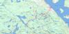
New Liskeard Topo Map Online
Download Free Topo Map Sheet 031M12 at 1:50,000 scale
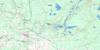
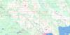
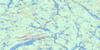
031M12 New Liskeard Topo Map
To view this map, mouse over the map preview on the right.
You can also download this topo map for free:
031M12 New Liskeard high-resolution topo map image.
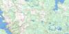
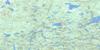
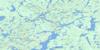
Maps for the New Liskeard topo map sheet 031M12 at 1:50,000 scale are also available in these versions:
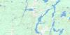
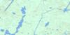
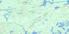
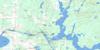
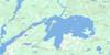
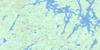
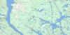
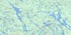
New Liskeard Surrounding Area Topo Maps
 |
 |
 |
 |
 |
 |
 |
 |
 |
 |
 |
 |
 |
 |
 |
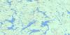 |
© Department of Natural Resources Canada. All rights reserved.
New Liskeard Gazetteer
The following places can be found on topographic map sheet 031M12 New Liskeard:
New Liskeard Topo Map: Bays
Baie PaulsonBlack Bay
Burnt Bay
Gilchrist Bay
Sucker Gut Bay
Sutton Bay
The Boot Leg
Wabi Bay
Windy Arm
New Liskeard Topo Map: Capes
Booming Out PointBurnt Point
Jumbo Point
You-go I-go Point
New Liskeard Topo Map: Channels
Chenal du DiableChenal du Diable
The Narrows
New Liskeard Topo Map: City
Temiskaming ShoresNew Liskeard Topo Map: Cliffs
Côte à LemieuxNew Liskeard Topo Map: Falls
Redpine ChutesNew Liskeard Topo Map: Geographical areas
ArmstrongBeauchamp
Brethour
Casey
Dymond
Harley
Harris
Henwood
Hilliard
Hudson
Kerns
Lundy
Montreuil
Nédelec
Nédélec
Timiskaming
New Liskeard Topo Map: Indian Reserves
Réserve indienne Timiskaming 19Timiskaming
Timiskaming Indian Reserve 19
New Liskeard Topo Map: Islands
Dynamite IslandÎle du Chef
Île Rempnouix
Rempnouix Island
Rousselet Island
Snake Island
Sugarloaf Island
New Liskeard Topo Map: Lakes
Aleck's PondBailey Lake
Bartle Lake
Blanche Lake
Blueberry Lake
Callicut Lake
Collacutt Lake
Cyril Lake
Divide Lake
Echo Lake
Elk Pit
Frere Lake
Hammond Lake
Head Lake
Henwood Lake
Hidden Lake
High Falls Lake
Hudfir Lake
Ice Chisel Lake
Lac LeMoyne
Lac René
Lac Témiscamingue
Lac Témiscamingue
Lake Timiskaming
Larabie Lake
Le Moyne Lake
Little Black Lake
Little Blueberry Lake
Little Gillies Lake
Little Grassy Lake
Little Sharp Lake
Little Spring Lake
Long Lake
Lost Lake
Lundy Lake
Maggie Lake
Mary Ann Lake
Mayfair Pond
McChesney Lake
Pacey Lake
Pike Lake
Professor Pond
Second Justin Lake
Spring Lake
Taylor Lake
Twin Lakes
Wabi Lake
Woodpecker Lake
New Liskeard Topo Map: Mountains
Casey MountainEdison Mountain
Fisher's Rock
Hooper's Rock
McConnell Rock
Montagne Casey
New Liskeard Topo Map: Other municipal/district area - miscellaneous
ArmstrongBrethour
Casey
Dymond
Harley
Harris
Hilliard
Hudson
Kerns
New Liskeard Topo Map: Conservation areas
Henwood Township Forest and Wetland Conservation ReserveHilliardton Marsh Conservation Reserve
New Liskeard Topo Map: Rivers
Blanche RiverBurwash Creek
Calamity Creek
Cours d'eau de la Ligne Interprovinciale
Cours d'eau Laferrière
Cours d'eau Lambert
Cours d'eau McLean-Rivard
Evanturel Creek
Gilchrist Creek
Grahams Creek
Hound Chute Creek
Hudfir Creek
Hudson Creek
Ingram Creek
Julian Creek
Kelvin Creek
Leacock Creek
Lepha Creek
Little Otterskin Creek
McLaren Creek
Moffatt Creek
Moose Creek
Ottawa River
Pike Creek
Pontleroy Creek
Rivière des Outaouais
Rivière des Outaouais
Rivière Wabi
Ruisseau Burwash
Ruisseau Julian
Ruisseau Wright
Ruisseau Wright Ouest
South Wabi Creek
St. Jean Baptiste Creek
Sucker Gut Creek
Sutton Creek
Wabi Creek
Wadi's Creek
Wright Creek
New Liskeard Topo Map: Shoals
Hudson RockNew Liskeard Topo Map: Unincorporated areas
Belle ValléeBrethour
Couttsville
Dymond
Earlton
Elk Pit
Hanbury
Highland
Hilliardton
Hillview
Judge
Kenabeek
Maybrook
McCool
Milberta
New Liskeard
Pearson
Sutton Bay
Thorncrest Village
Thwaites
Uno Park
Village à Breault
Whitewood Grove
New Liskeard Topo Map: Valleys
Calamity GulchNew Liskeard Topo Map: Low vegetation
Edison MarshHilliardton Swamp
New Liskeard Topo Map: Villages
Thornloe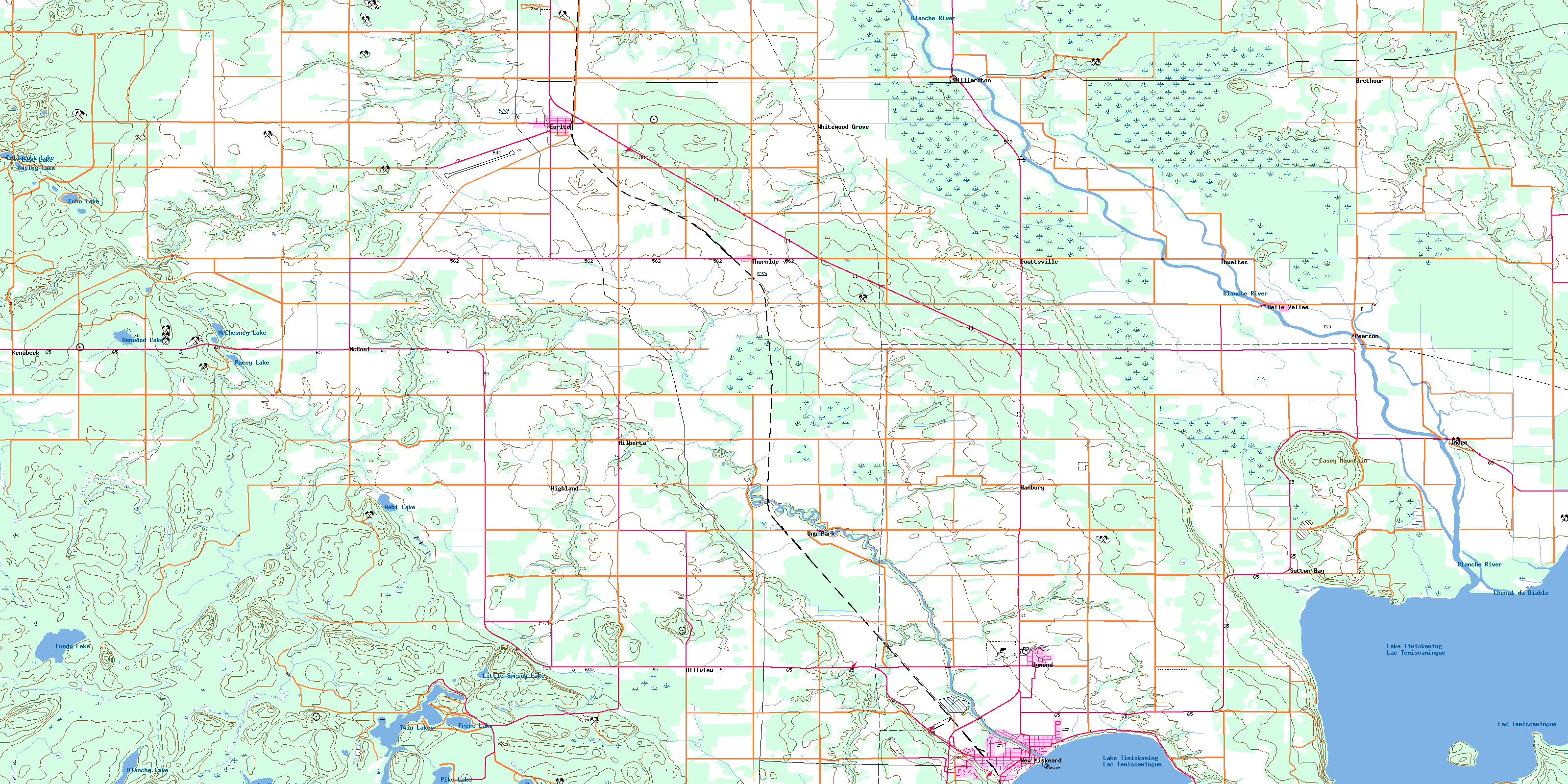
© Department of Natural Resources Canada. All rights reserved.
031M Related Maps:
031M Ville-Marie031M01 Lac Ogascanane
031M02 Lac Ostaboningue
031M03 Fabre
031M04 Temagami
031M05 Cobalt
031M06 Ville-Marie
031M07 Belleterre
031M08 Lac Winawiash
031M09 Lac Nodier
031M10 Lac Simard
031M11 Angliers
031M12 New Liskeard
031M13 Englehart
031M14 Lac Barriere
031M15 Lac Roger
031M16 Lac Mourier
