Prince Rupert Topo Map Online
Download Free Topo Map Sheet 103J08 at 1:50,000 scale
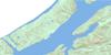
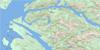
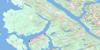
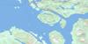
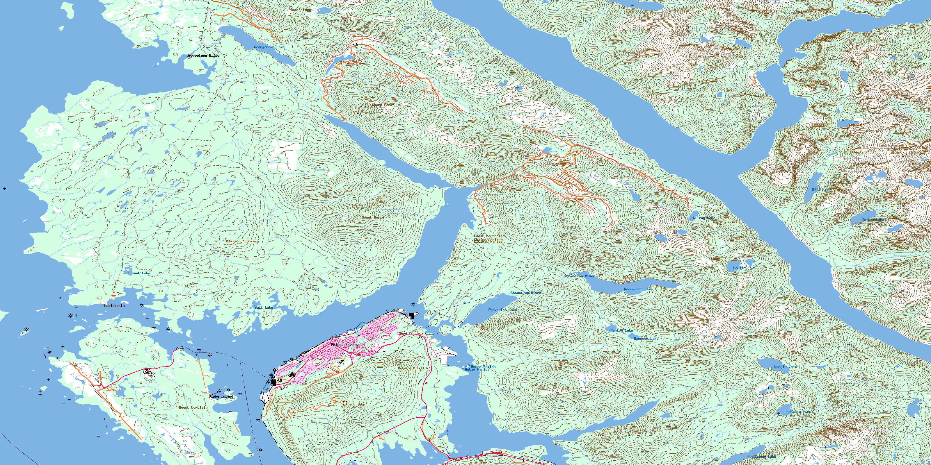
103J08 Prince Rupert Topo Map
To view this map, mouse over the map preview on the right.
You can also download this topo map for free:
103J08 Prince Rupert high-resolution topo map image.
Maps for the Prince Rupert topo map sheet 103J08 at 1:50,000 scale are also available in these versions:
Prince Rupert Surrounding Area Topo Maps
 |
|||
 |
 |
||
 |
 |
||
 |
 |
 |
© Department of Natural Resources Canada. All rights reserved.
Prince Rupert Gazetteer
The following places can be found on topographic map sheet 103J08 Prince Rupert:
Prince Rupert Topo Map: Bays
Bacon CoveBig Bay
Boundary Cove
Casey Cove
Chatham Sound
Cow Bay
Crippen Cove
Delusion Bay
Denise Arm
Denise Inlet
Dodge Cove
Duncan Bay
Hays Cove
Hill Cove
Hospital Cove
Kloiya Bay
Laurier Cove
Melville Arm
Metlakatla Bay
Miller Bay
Morse Basin
Osborn Cove
Philips Cove
Pillsbury Cove
Prince Rupert Harbour
Quottoon Inlet
Russell Arm
Salmon Bight
Salmon River Bight
Scott Inlet
Seal Cove
Shkgeaum Bay
Sourdough Bay
Tuck Inlet
Wainwright Basin
Prince Rupert Topo Map: Capes
Auriol PointBacon Point
Beatty Point
Belletti Point
Butze Point
Camp Point
Casey Point
Charles Point
Cultivation Point
David Point
de Stein Point
De Stein Point
Doolan Point
Douglas Point
Du Vernet Point
Dundas Point
East Base Point
Elizabeth Point
Emmerson Point
Fairview Point
Frederick Point
Grindstone Point
Henry Point
Jap Point
Miller Point
Mission Point
Observation Point
Parizeau Point
Pattullo Point
Pearl Point
Pepin Point
Pethick Point
Philips Point
Pillsbury Point
Quottoon Point
Reeks Point
Reservation Point
Ritchie Point
Roberson Point
Russell Point
Ryan Point
Schreiber Point
Shattock Point
Simpson Point
Straith Point
Tobey Point
Trenham Point
Tsimpsean Peninsula
Tuck Point
West Base Point
Prince Rupert Topo Map: Channels
Fern PassageNorth Arm of Work Channel
North Passage
Quottoon Narrows
South Passage
Tuck Narrows
Venn Passage
Wark Channel
Work Channel
Prince Rupert Topo Map: City
Prince RupertPrince Rupert Topo Map: Cliffs
Tree BluffPrince Rupert Topo Map: Indian Reserves
Bill Lake Indian Reserve 37Burnt Cliff Islands Indian Reserve 20
Kasika Indian Reserve 36
Lax Kw'alaams 1
Lax Kw'alaams Indian Reserve 1
Ndakdolk Indian Reserve 54
Nishanocknawnak Indian Reserve 35
Port Simpson Indian Reserve 1
Réserve indienne Bill Lake 37
Réserve indienne Burnt Cliff Islands 20
Réserve indienne Kasika 36
Réserve indienne Lax Kw'alaams 1
Réserve indienne Ndakdolk 54
Réserve indienne Nishanocknawnak 35
Réserve indienne Port Simpson 1
Réserve indienne Shoowahtlans (Shawtlans) 4
Réserve indienne Spanaknok 57
Réserve indienne Spayaks 60
Réserve indienne Tsimpsean 2
Réserve indienne Tuck Inlet 89
Réserve indienne Tugwell Island 21
Réserve indienne Wilnaskancaud 3
Réserve indienne Wilskaskammel 14
S1/2 Tsimpsean 2
Shoowahtlans (Shawtlans) Indian Reserve 4
Spanaknok Indian Reserve 57
Spayaks Indian Reserve 60
Tsimpsean Indian Reserve 2
Tuck Inlet Indian Reserve 89
Tugwell Island Indian Reserve 21
Wilnaskancaud Indian Reserve 3
Wilskaskammel Indian Reserve 14
Prince Rupert Topo Map: Islands
Anian IslandBurnt Cliff Island
Burrowes Island
Carolina Island
Carolina Islands
Carr Island
Cridge Island
Detention Island
Devastation Island
Digby Island
Dodge Island
Garden Island
Gribbell Islet
Grindstone Island
Haycock Island
Hill Island
Isabel Islet
Kaien Island
Knight Island
Little Cridge Island
Martini Island
Naden Islets
Pike Island
Ritchie Island
Shrub Island
Snider Islet
South Island
Swallow Island
Swamp Island
Tugwell Island
Verney Island
Vigilant Island
White Cliff Island
Whitecliff Island
Wilgiapshi Island
Wolfe Island
Prince Rupert Topo Map: Lakes
Bannock LakeBencke Lagoon
Bill Lake
Dudoward Lake
Georgetown Lake
Gilroy Lake
Kergin Lake
Louise Lake
Mahlon Lake
Marion Lake
Ndakdolk Lake
Oliver Lake
Prudhomme Lake
Salt Lake
Sarah Lake
Shawatlan Lake
Tsook Lake
Woodworth Lake
Prince Rupert Topo Map: Mountains
Basil LumpChaîne Côtière
Coast Mountains
Keen Hills
Kitimat Ranges
Mission Mountain
Mount Comblain
Mount Hays
Mount Morse
Mount Oldfield
Prospect Hill
Sharp Peak
Shattock Hill
Prince Rupert Topo Map: Conservation areas
Oliver Lake ParkPrudhomme Lake Park
Salt Lake Park
Prince Rupert Topo Map: Rapids
Butze RapidsPrince Rupert Topo Map: Rivers
Bill CreekDenise Creek
Fortune Creek
Georgetown Creek
Gilroy Creek
Hays Creek
Kaien Creek
Kloiya River
Large Creek
Louise Creek
Marion Creek
McNichol Creek
McShane Creek
Morse Creek
Sarah Creek
Scissors Creek
Shawatlan River
Silver Creek
Prince Rupert Topo Map: Sea features
Galloway RapidsPrince Rupert Topo Map: Shoals
Alford ReefsAnchor Shoal
Armour Rock
Arthur Rock
Clutch Rock
Curlew Rock
Cutch Rock
Entry Rock
Escape Reefs
Hecate Rock
Hogan Ledge
Kelp Reef
Kelp Rock
Kerr Rocks
Leading Shoal
McIntosh Rock
Midge Rock
One Foot Rock
Quartermaster Rock
Ripple Bank
Scattered Reefs
Slippery Rock
Snider Rock
Stork Rock
Prince Rupert Topo Map: Unincorporated areas
Digby IslandDigby Island
Dodge Cove
Georgetown Mills
Metlakatla
Norwegian Village
Oldfield
© Department of Natural Resources Canada. All rights reserved.
