Centreville Satellite Image Map
Download Free Aerial Photo 021B09 at 1:50,000 scale
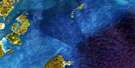
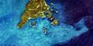
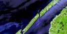
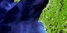
Centreville Satellite Imagery
To view this satellite map, mouse over the air photo on the right.
You can also download this satellite image map for free:
021B09 Centreville high-resolution satellite image map.
Maps for the Centreville aerial map sheet 021B09 at 1:50,000 scale are also available in these versions:
Centreville Surrounding Area Aerial Photo Maps
 |
|||
 |
 |
||
 |
|||
 |
© Department of Natural Resources Canada. All rights reserved.
Centreville Gazetteer
The following places can be found on satellite image map 021B09 Centreville:
Centreville Satellite Image: Bays
Baie de FundyBay of Fundy
Centre Cove
Deep Cove
First Cove
Lake Brook Cove
Little Cove
Little Deep Cove
Log Cove
Rileys Cove
Shingle Cove
St. Mary Bay
St. Marys Bay
St. Mary's Bay
Tar Cove
Thomas Cove
Trout Cove
Centreville Satellite Image: Capes
Digby NeckLong Point
Lower Point
Shipyards Point
Upper Point
Centreville Satellite Image: Channels
Deepwater ChannelCentreville Satellite Image: Cliffs
The BluffCentreville Satellite Image: Geographical areas
DigbyCentreville Satellite Image: Lakes
Lake MidwayMidway Lake
Centreville Satellite Image: Mountains
Mount ShubleyNorth Mountain
Centreville Satellite Image: Major municipal/district area - major agglomerations
DigbyCentreville Satellite Image: Conservation areas
Lake Midway Provincial ParkCentreville Satellite Image: Rivers
Lake BrookCentreville Satellite Image: Shoals
Clarks GroundFishing Rock
St. Mary Shoal
St. Marys Bay Shoal
Centreville Satellite Image: Unincorporated areas
CentrevilleLake Midway

© Department of Natural Resources Canada. All rights reserved.
