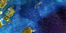
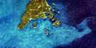
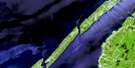
Grand Manan Island Satellite Image Map
Download Free Aerial Photo 021B10 at 1:50,000 scale
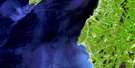
Grand Manan Island Satellite Imagery
To view this satellite map, mouse over the air photo on the right.
You can also download this satellite image map for free:
021B10 Grand Manan Island high-resolution satellite image map.
Maps for the Grand Manan Island aerial map sheet 021B10 at 1:50,000 scale are also available in these versions:
Grand Manan Island Surrounding Area Aerial Photo Maps
 |
|||
 |
 |
||
 |
|||
 |
© Department of Natural Resources Canada. All rights reserved.
Grand Manan Island Gazetteer
The following places can be found on satellite image map 021B10 Grand Manan Island:
Grand Manan Island Satellite Image: Bays
Baie de FundyBay of Fundy
Bay of Fundy
Bradford Cove
Chalk Cove
Dark Harbour
Deep Cove
Dwellys Cove
Grand Harbour
Gull Cove
Hardwood Cove
Harrington Cove
Hay Point Cove
Herring Cove
Jack Tars Cove
Jack Tar's Cove
Langmaid Cove
Little Dark Harbour
Long Island Bay
Long Pond Bay
Pandora Cove
Pats Cove
Pat's Cove
Priest Cove
Sandy Cove
Seal Cove
Sloop Cove
Sloop Cove
The Basin
Three Island Harbour
Two Islands Harbour
White Head Harbour
Wood Island Harbour
Woodwards Cove
Grand Manan Island Satellite Image: Beaches
Battle BeachGreen Island Breaker
Long Pond Beach
Middle Breaker
Shag Head Breaker
South Head Beach
Grand Manan Island Satellite Image: Capes
Bancroft PointBig Head
Browns Point
Brown's Point
Columbia Head
Fish Fluke Point
Fresh Pond Point
Hay Point
Indian Camp Point
Joes Point
Joe's Point
Long Point
Marsh Point
Mikes Point
Northeast Point
Northern Point
Ox Head
Pandora Head
Parker Point
Pats Head
Philips Point
Prangle Point
Ragged Point
Red Head
Red Point
Salt Pond Point
Shag Head
Sheep Point
Sheep Rock Head
South Point
Southern Head
Southwest Head
White Head
Wilcox Point
Grand Manan Island Satellite Image: Channels
Cheney PassageCow Passage
Grand Manan Channel
The Thoroughfare
Grand Manan Island Satellite Image: Cliffs
Gull CliffThe Bluff
The Ladders
Grand Manan Island Satellite Image: Falls
Singing FallsGrand Manan Island Satellite Image: Geographical areas
CharlotteGrand Manan
Grand Manan Island Satellite Image: Islands
Bills IsletCheney Island
Grand Manan
Grand Manan Island
Great Duck Island
Green Islands
Gull Islet
Hay Island
High Duck Island
Kent Island
Long Island
Low Duck Island
Machias Seal Island
Nantucket Island
North Green Island
Outer Wood Island
Pumpkin Islet
Rock Island
Ross Island
Sams Islet
Sheep Island
South Green Island
Three Islands
West Pumpkin Island
Western Green Island
White Head Island
White Horse Islet
Wood Island
Grand Manan Island Satellite Image: Lakes
Big PondBradford Cove Pond
David Watt Pond
Dwellys Pond
Great Pond
Little Round Pond
Long Pond
Marsh Point Pond
Miller Pond
Northern Pond
Rockweed Pond
Round Pond
Salt Pond
Sandy Cove Pond
West Long Pond
Grand Manan Island Satellite Image: Mountains
Beech HillLaborie Hill
Maple Hill
Mark Hill
Temple Hill
Grand Manan Island Satellite Image: Conservation areas
Anchorage Provincial ParkCastalia Provincial Park
Grand Manan Bird Sanctuary
Refuge d'oiseaux de Grand Manan
Grand Manan Island Satellite Image: Provinces
New BrunswickNouveau-Brunswick
Grand Manan Island Satellite Image: Rapids
Three Islands EddyGrand Manan Island Satellite Image: Rivers
Bleumortier BrookBonney Brook
Bradbury Brook
Dark Harbour Brook
Deep Cove Brook
East Brook
Grand Brook
Merry Brook
Mill Brook
Seal Cove Brook
Trout Brook
Western Brook
Grand Manan Island Satellite Image: Sea features
Bulkhead RipGrand Manan Island Satellite Image: Shoals
Andys LedgeAndy's Ledge
Bigwood Rock
Black Rock
Black Rocks
Brazil Shoal
Buck Rock
Bull Rock
Cassie Shoals
Clarks Ground
Constable Ledge
Crack Grounds
Crawley Shoal
Cronk Grounds
Cross Jack Ledge
Cross Jack Shoal
Devils Half Acre
Dutch Ledge
Eastern Ledge
Edmunds Rock
Farmer Ledge
Gannet Rock
Gannet Rock Bank
Great Duck Ledge
Green Island Ledges
Green Island Shoal
Green Islands Shoal
Greens Ledge
Gull Rock
Guptill Grounds
Haley Knoll Shoal
Half Tide Rock
Half Tide Rock
Half Tide Rock
Half Tide Rock (Shag Rock)
Halibut Rock
Harbour Ledges
Hatt Grounds
Haycock Rock
Herring Ledge
Ingalls Grounds
Inner Diamond
Kent Shoal
Leems Shoal
Little Shoal
Long Ledge
Long Ledge
MacGregors Reef
Meeting House Grounds
Middle Shoal
Murr Ledges
North Rock
North Shoal
Old Proprietor Shoal
Outer Diamond
Outer Kent Shoal
Ox Head Ledges
Pollock Shoal
Pond Point Ledges
Proprietor Shoal
Rans Shoal
Sand Bar
Sand Bar Ledge
Sand-Bar
Sand-Bar Ledge
Sheep Island Shoal
Sister Rocks
Southeast Shoal
Southern Cross
Southern Head Reef
Southern Ledge Shoal
St. Mary Ledge
Sugar Bowl
Temmy Shoals
Tinker Shoal
Wallace Ledge
Welly Shoal
White Horse Grounds
White Ledge
Yellow Ledge
Grand Manan Island Satellite Image: Unincorporated areas
CastaliaDeep Cove
Grand Harbour
Greens Landing
Ingalls Head
Mark Hill
Seal Cove
White Head
Wood Island
Woodwards Cove
Grand Manan Island Satellite Image: Valleys
Grand ValleyGrand Manan Island Satellite Image: Low vegetation
Bald HeathBog Heath
Castalia Marsh
Gordon Heath
Gull Heath
Herring Cove Heath
Huntley Heath
Laborie Marsh
Seal Cove Meadow
Grand Manan Island Satellite Image: Villages
Grand Manan
© Department of Natural Resources Canada. All rights reserved.
