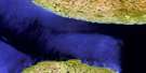
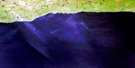
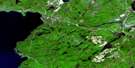
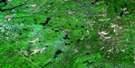
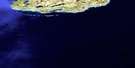
Dog Harbour Satellite Image Map
Download Free Aerial Photo 041N14 at 1:50,000 scale
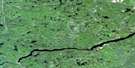
Dog Harbour Satellite Imagery
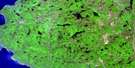
To view this satellite map, mouse over the air photo on the right.
You can also download this satellite image map for free:
041N14 Dog Harbour high-resolution satellite image map.
Maps for the Dog Harbour aerial map sheet 041N14 at 1:50,000 scale are also available in these versions:
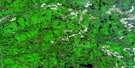
Dog Harbour Surrounding Area Aerial Photo Maps
 |
 |
 |
 |
 |
 |
 |
|
 |
 |
 |
|
 |
 |
© Department of Natural Resources Canada. All rights reserved.
Dog Harbour Gazetteer
The following places can be found on satellite image map 041N14 Dog Harbour:
Dog Harbour Satellite Image: Bays
Dog HarbourDog Harbour
False Dog Harbour
Little Dog Harbour
McCoy's Harbour
Tamarack Bay
Dog Harbour Satellite Image: Capes
Minnekona PointPoint Isacor
Dog Harbour Satellite Image: Falls
Denison FallsDog Harbour Satellite Image: Geographical areas
31,2332,23
33,23
Algoma
Bostwick
Franchère
Groseilliers
Thunder Bay
Dog Harbour Satellite Image: Lakes
Denison LakeLac Supérieur
Lake Superior
Little Trout Lake
Missing Lake
Dog Harbour Satellite Image: Mountains
Bare SummitMountain Ash Hill
Dog Harbour Satellite Image: Rivers
Campbell CreekDog (University) River
Dog River
Eagle River
Floating Heart River
Ghost River
Little Bear River
Little Ghost River
Makwa River
Mountain Ash River
Tamarack Creek
University River
Dog Harbour Satellite Image: Low vegetation
The Flats
© Department of Natural Resources Canada. All rights reserved.
