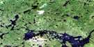
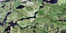
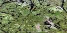
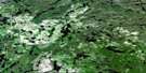
Linklater Lake Satellite Image Map
Download Free Aerial Photo 052I10 at 1:50,000 scale
Linklater Lake Satellite Imagery
To view this satellite map, mouse over the air photo on the right.
You can also download this satellite image map for free:
052I10 Linklater Lake high-resolution satellite image map.
Maps for the Linklater Lake aerial map sheet 052I10 at 1:50,000 scale are also available in these versions:
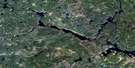
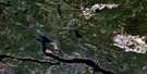
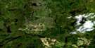
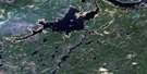
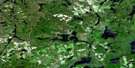
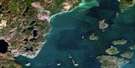
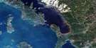
Linklater Lake Surrounding Area Aerial Photo Maps
 |
 |
 |
 |
 |
 |
 |
 |
 |
 |
 |
 |
 |
 |
 |
 |
© Department of Natural Resources Canada. All rights reserved.
Linklater Lake Gazetteer
The following places can be found on satellite image map 052I10 Linklater Lake:
Linklater Lake Satellite Image: Bays
Kellar BayLinklater Lake Satellite Image: Islands
Kellar IslandLinklater Lake Satellite Image: Lakes
Amra LakeArnston Lake
Bad Medicine Lake
Butland Lake
Campbell Lake
Caribou Lake
Clerc Lake
Cliff Lake
Collaton Lake
Cosmo Lake
Cumaway Lake
D'Alton Lake
Dazzle Lake
Dewy Lake
Fletcher Lake
Fuchsite Lake
Gort Lake
Hollingsworth Lake
Howie Lake
Lee Lake
Linklater Lake
Lower Pawshowconk Lake
Macdonald Lake
MacLaren Lake
Medallion Lake
Moonshine Lake
Mund Lake
Pawshowconk Lake
Ratte Lake
Raymond Lake
Revilo Lake
Rhodes Lake
Ruxton Lake
Scallop Lake
Linklater Lake Satellite Image: Mountains
Kellar PeakLinklater Lake Satellite Image: Conservation areas
Wabakimi Provincial ParkLinklater Lake Satellite Image: Rivers
Big RiverCampbell Creek
Caribou River
Cumaway Creek
Dazzle Creek
Dewy Creek
Linklater Creek
Pikitigushi River
Raymond River
Scamp Creek

© Department of Natural Resources Canada. All rights reserved.
052I Related Maps:
052I Armstrong052I01 Ombabika Bay
052I02 Castle Lake
052I03 Wigwasan Lake
052I04 Aldridge Lake
052I05 Onamakawash Lake
052I06 Armstrong
052I07 Pikitigushi Lake
052I08 Little Jackfish River
052I09 Mojikit Lake
052I10 Linklater Lake
052I11 Goldsborough Lake
052I12 Wabakimi Lake
052I13 Burntrock Lake
052I14 Grayson Lake
052I15 Whiteclay Lake
052I16 D'Orsonnens Lake
