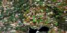
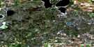
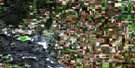
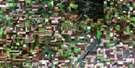
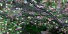
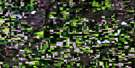
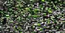
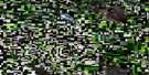
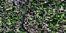
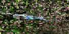
Wilkie Satellite Image Map
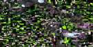
Download Free Aerial Photo 073C07 at 1:50,000 scale
Wilkie Satellite Imagery
To view this satellite map, mouse over the air photo on the right.
You can also download this satellite image map for free:
073C07 Wilkie high-resolution satellite image map.
Maps for the Wilkie aerial map sheet 073C07 at 1:50,000 scale are also available in these versions:
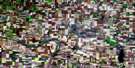
Wilkie Surrounding Area Aerial Photo Maps
 |
 |
 |
 |
 |
 |
 |
 |
 |
 |
 |
 |
 |
 |
 |
 |
© Department of Natural Resources Canada. All rights reserved.
Wilkie Gazetteer
The following places can be found on satellite image map 073C07 Wilkie:
Wilkie Satellite Image: Beaches
Wilkie BeachWilkie Satellite Image: Cliffs
The CoteauWilkie Satellite Image: Indian Reserves
Poundmaker 114-10APoundmaker 114-12
Poundmaker 114-4A
Poundmaker 114-9
Poundmaker 114-9A
Wilkie Satellite Image: Lakes
Aroma LakeColdspring Lake
Eaglehill Lake
Highbank Lake
Tramping Lake
Wilkie Satellite Image: Other municipal/district area - miscellaneous
Battle River No. 438Buffalo No. 409
Prairie No. 408
Prairie No. 408
Reford No. 379
Round Valley No. 410
Tramping Lake No. 380
Wilkie Satellite Image: Conservation areas
Wilkie Regional ParkWilkie Satellite Image: Rivers
Dempster BrookEagle Creek
Wilkie Satellite Image: Towns
ScottWilkie
Wilkie Satellite Image: Unincorporated areas
BrassBush
Cathkin
Cavell
Phippen
Reford
St. Alphege
Wilkie Beach
Wolfe

© Department of Natural Resources Canada. All rights reserved.
