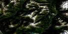
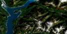
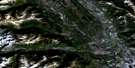
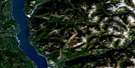
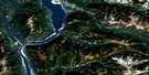
Findlay Creek Satellite Image Map
Download Free Aerial Photo 082K01 at 1:50,000 scale
Findlay Creek Satellite Imagery
To view this satellite map, mouse over the air photo on the right.
You can also download this satellite image map for free:
082K01 Findlay Creek high-resolution satellite image map.
Maps for the Findlay Creek aerial map sheet 082K01 at 1:50,000 scale are also available in these versions:
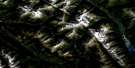
Findlay Creek Surrounding Area Aerial Photo Maps
 |
 |
 |
 |
 |
 |
 |
 |
 |
 |
 |
 |
 |
 |
 |
 |
© Department of Natural Resources Canada. All rights reserved.
Findlay Creek Gazetteer
The following places can be found on satellite image map 082K01 Findlay Creek:
Findlay Creek Satellite Image: Glaciers
Findlay GlacierToby Glacier
Findlay Creek Satellite Image: Lakes
Duncan LakeWhitetail Lake
Findlay Creek Satellite Image: Mountains
Barn MountainColumbia Mountains
Doctor Peak
Duchess Peak
Hyak Mountain
Midge Peak
Mount Clutterbuck
Mount Findlay
Mount Lees
Mount Morigeau
Mount Peechee
Mount Rowand
Mount St. Maur
Pert Peak
Purcell Mountains
Saffron Peak
Trikootenay Peak
Findlay Creek Satellite Image: Major municipal/district area - major agglomerations
Regional District of Central KootenayRegional District of East Kootenay
Findlay Creek Satellite Image: Conservation areas
Purcell Wilderness ConservancyPurcell Wilderness Conservancy Park
Findlay Creek Satellite Image: Rivers
Alton CreekCarney Creek
Clear Creek
Deer Creek
Doctor Creek
Dutch Creek
Findlay Creek
Fry Creek
Frying Pan Creek
Granite Creek
Honeysuckle Creek
Huckleberry Creek
Middle Findlay Creek
Morigeau Creek
Periwinkle Creek
South Toby Creek
Valentine Creek
Whitetail Creek

© Department of Natural Resources Canada. All rights reserved.
082K Related Maps:
082K Lardeau082K01 Findlay Creek
082K02 Lardeau
082K03 Rosebery
082K04 Nakusp
082K05 St Leon Creek
082K06 Poplar Creek
082K07 Duncan Lake
082K08 Toby Creek
082K09 Radium Hot Springs
082K10 Howser Creek
082K11 Trout Lake
082K12 Beaton
082K13 Camborne
082K14 Westfall River
082K15 Bugaboo Creek
082K16 Spillimacheen
