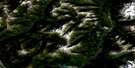
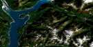
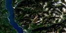
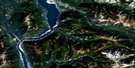
Spillimacheen Satellite Image Map
Download Free Aerial Photo 082K16 at 1:50,000 scale
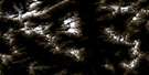
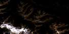
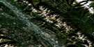
Spillimacheen Satellite Imagery
To view this satellite map, mouse over the air photo on the right.
You can also download this satellite image map for free:
082K16 Spillimacheen high-resolution satellite image map.
Maps for the Spillimacheen aerial map sheet 082K16 at 1:50,000 scale are also available in these versions:
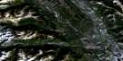
Spillimacheen Surrounding Area Aerial Photo Maps
 |
 |
 |
 |
 |
 |
 |
 |
 |
 |
 |
 |
 |
 |
 |
 |
© Department of Natural Resources Canada. All rights reserved.
Spillimacheen Gazetteer
The following places can be found on satellite image map 082K16 Spillimacheen:
Spillimacheen Satellite Image: Channels
Baldy ChannelBotts Channel
Hotsprings Channel
Spillimacheen Satellite Image: Lakes
Big Fish LakeBotts Lake
Burns Lake
Cartwright Lake
Cleland Lake
Cub Lake
Diana Lake
Halfway Lake
Jade Lake
Jordan Lake
Kootenay Pond
Lang Lake
Leadqueen Lake
Longs Lake
Moose Lake
Topaz Lake
Twin Lakes
Wells Lakes
Whary Lake
Spillimacheen Satellite Image: Mountains
Beaverfoot RangeBrisco Range
Columbia Mountains
Jubilee Mountain
Kootenay Ranges
Montagnes Rocheuses
Mount Crook
Mount Norman
Mount Wardle
Purcell Mountains
Rocky Mountains
Steamboat Mountain
Vermilion Range
Spillimacheen Satellite Image: Major municipal/district area - major agglomerations
Columbia-Shuswap Regional DistrictRegional District of East Kootenay
Spillimacheen Satellite Image: Conservation areas
Columbia National Wildlife AreaKootenay National Park of Canada
Parc national du Canada Kootenay
Réserve nationale de faune de Columbia
Spillimacheen Satellite Image: Rivers
Body CreekBoyce Creek
Brisco Creek
Brisco Creek
Bryanton Creek
Bugaboo Creek
Cedared Creek
Columbia River
Dolly Varden Creek
Dollyvarden Creek
Driftwood Creek
Dunbar Creek
Fleuve Columbia
Fraling Creek
Frances Creek
Hatch Creek
Hot Creek
Kindersley Creek
Kootenay River
Lost Creek
Luxor Creek
McCready Creek
Meadow Creek
Outlet Creek
Paul Creek
Pinnacle Creek
Pratt Creek
Rand Creek
Soles Creek
Spillimacheen River
Symond Creek
Templeton River
Verendrye Creek
Vermilion River
Wardle Creek
Whitetail Creek
Spillimacheen Satellite Image: Unincorporated areas
BriscoHarrogate
Kootenay Crossing
Luxor
Spillamacheen
Spillimacheen
Spillimacheen Satellite Image: Valleys
Hector GorgeLuxor Pass
Rocky Mountain Trench

© Department of Natural Resources Canada. All rights reserved.
082K Related Maps:
082K Lardeau082K01 Findlay Creek
082K02 Lardeau
082K03 Rosebery
082K04 Nakusp
082K05 St Leon Creek
082K06 Poplar Creek
082K07 Duncan Lake
082K08 Toby Creek
082K09 Radium Hot Springs
082K10 Howser Creek
082K11 Trout Lake
082K12 Beaton
082K13 Camborne
082K14 Westfall River
082K15 Bugaboo Creek
082K16 Spillimacheen
