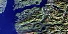
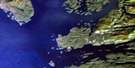
Smith Inlet Satellite Image Map
Download Free Aerial Photo 092M06 at 1:50,000 scale
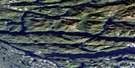
Smith Inlet Satellite Imagery
To view this satellite map, mouse over the air photo on the right.
You can also download this satellite image map for free:
092M06 Smith Inlet high-resolution satellite image map.
Maps for the Smith Inlet aerial map sheet 092M06 at 1:50,000 scale are also available in these versions:
Smith Inlet Surrounding Area Aerial Photo Maps
 |
 |
 |
 |
 |
 |
 |
 |
 |
 |
 |
 |
 |
 |
 |
 |
© Department of Natural Resources Canada. All rights reserved.
Smith Inlet Gazetteer
The following places can be found on satellite image map 092M06 Smith Inlet:
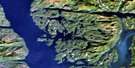
Smith Inlet Satellite Image: Bays
Allard BayAnchor Cove
Boswell Inlet
Burnt Island Harbour
Draney Inlet
East Arm Smith Inlet
Hickey Cove
Margaret Bay
Naysash Bay
Naysash Inlet
Quascilla Bay
Robert Arm
Security Bay
Security Cove
Smith Inlet
Walkum Bay
Smith Inlet Satellite Image: Capes
Adelaide PointCape Anne
Smith Inlet Satellite Image: Channels
Ahclakerho ChannelSmith Inlet Satellite Image: Indian Reserves
Halowis Indian Reserve 5Nekite Indian Reserve 2
Réserve indienne Halowis 5
Réserve indienne Nekite 2
Réserve indienne Tseetsum-Sawlasilah 6
Réserve indienne Wyclese 1
Tseetsum-Sawlasilah Indian Reserve 6
Wyclese Indian Reserve 1
Smith Inlet Satellite Image: Islands
Ahclakerho IslandsBurnt Island
Greaves Island
Jap Island
Twain Islands
Smith Inlet Satellite Image: Lakes
Allard LakeAnna Lake
Annabelle Lake
Boomer Lake
Caroline Lake
Gordon Lake
Gordon Lakes
Jean Lake
Long Lake
Piper Lake
Triangle Lake
Trout Lake
Wyclees Lagoon
Smith Inlet Satellite Image: Mountains
Chaîne CôtièreCoast Mountains
Pacific Ranges
Smith Inlet Satellite Image: Major municipal/district area - major agglomerations
Central Coast Regional DistrictRegional District of Mount Waddington
Smith Inlet Satellite Image: Rivers
Allard CreekBarer Creek
Boulder Creek
Canoe Creek
Draney Creek
Johnston Creek
Lockhart Gordon Creek
Lockhartgordon Creek
Margaret Creek
Naysash Creek
Nekite River
Piper River
Smokehouse Creek
Walkum Creek
Smith Inlet Satellite Image: River features
Broad ReachSmith Inlet Satellite Image: Unincorporated areas
Margaret BayNalos Landing

© Department of Natural Resources Canada. All rights reserved.
092M Related Maps:
092M Rivers Inlet092M01 Atwaykellesse River
092M02 Seymour Inlet
092M03 Belize Inlet
092M04 Cape Caution
092M05 Goose Bay
092M06 Smith Inlet
092M07 Mount Philley
092M08 Catto Creek
092M09 Machmell River
092M10 Owikeno Lake
092M11 Rivers Inlet
092M12 Fish Egg Inlet
092M13 Namu
092M14 Kilbella River
092M15 Tzeo River
092M16 Sheemahant River
