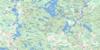
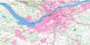
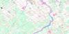
Hawkesbury Topo Map Online
Download Free Topo Map Sheet 031G10 at 1:50,000 scale
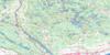
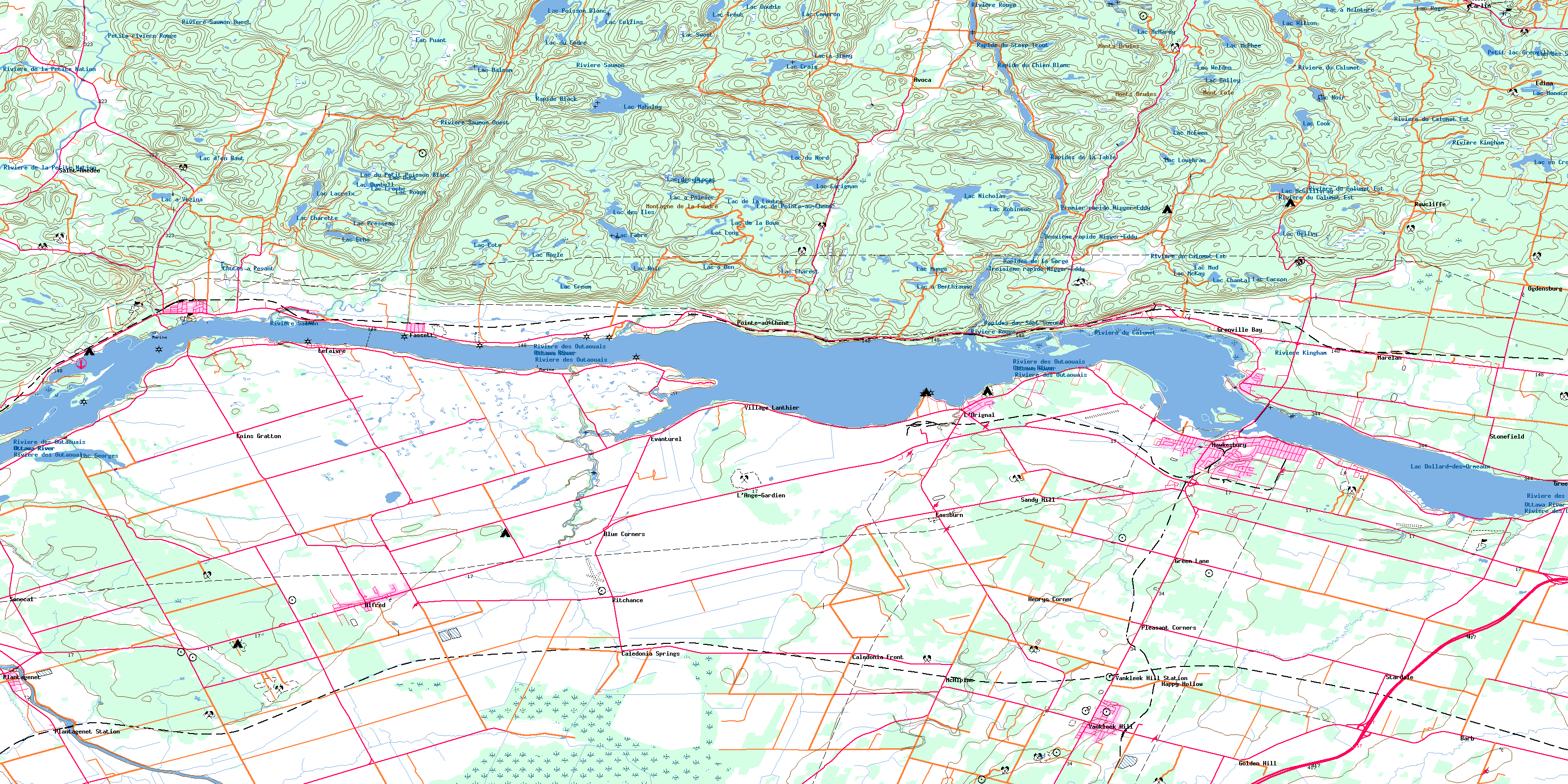
031G10 Hawkesbury Topo Map
To view this map, mouse over the map preview on the right.
You can also download this topo map for free:
031G10 Hawkesbury high-resolution topo map image.
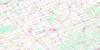
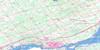
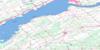
Maps for the Hawkesbury topo map sheet 031G10 at 1:50,000 scale are also available in these versions:
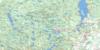
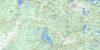
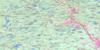
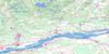
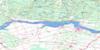
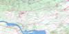
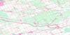
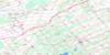
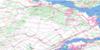
Hawkesbury Surrounding Area Topo Maps
 |
 |
 |
 |
 |
 |
 |
 |
 |
 |
 |
 |
 |
 |
 |
 |
© Department of Natural Resources Canada. All rights reserved.
Hawkesbury Gazetteer
The following places can be found on topographic map sheet 031G10 Hawkesbury:
Hawkesbury Topo Map: Bays
Azatika BayBaie chez Huneault
Baie chez Laurier-Laroche
Baie chez Lovell
Baie de Calumet
Baie de la Pentecôte
Baie de L'Orignal
Baie de Papineauville
Baie des Arcand
Baie des Atocas
Baie Grenville
Baie L'Orignal
Baie Pumpkinseed
Le McVicar
Hawkesbury Topo Map: Beaches
Batture à KempLe Déboulis
Hawkesbury Topo Map: Capes
Furniss PointGrants Point
Île à Crépault
La Grande Presqu'île
L'Île
McGovern Point
Pointe à Legault
Pointe au Chêne
Pointe aux Patates
Pointe de Laviolette
Pointe Filion
Pointe McTavish
Hawkesbury Topo Map: Channels
Canal de GrenvilleHawkesbury Topo Map: Falls
Chute FournelChutes à Pesant
Hawkesbury Topo Map: Geographical areas
AlfredCaledonia
Chatham
East Hawkesbury
Glengarry
Grenville
Lochiel
Longueuil
North Plantagenet
Notre-Dame-de-Bon-Secours
Notre-Dame-des-Sept-Douleurs
Plantagenet
Prescott
Saint-Fidèle
Saint-Ludger
Seigneurie de La Petite-Nation
South Plantagenet
West Hawkesbury
Hawkesbury Topo Map: Hydraulic construction
Charbonneau DrainHawkesbury Topo Map: Islands
Cobb IslandCobb's Island
Hamilton Island
Île à Roussin
Île Aroussen
Ile du Chenail
Île McVicar
Ile Ste-Rosalie
Miller Island
Periwig Island
Petite île Sèche
Stevens Island
Hawkesbury Topo Map: Lakes
George LakeLac à Ben
Lac à Berthiaume
Lac à Jimmy
Lac à la Loutre
Lac à la Perchaude
Lac à McIntyre
Lac à Poirier
Lac à Vézina
Lac Adub
Lac Angle
Lac Avoca
Lac Balsam
Lac Belley
Lac Brown
Lac Burks
Lac Cameron
Lac Canvasback
Lac Carignan
Lac Carson
Lac Chantal
Lac Charest
Lac Charette
Lac Collins
Lac Cook
Lac Côté
Lac Craig
Lac Creux
Lac Croche
Lac Crooked
Lac de la Boue
Lac de la Loutre
Lac de Pointe-au-Chêne
Lac d'en Haut
Lac des Atocas
Lac des Îles
Lac des Soeurs
Lac Dollard-des-Ormeaux
Lac Dollard-des-Ormeaux
Lac Double
Lac du Cèdre
Lac du Nord
Lac du Petit Poisson Blanc
Lac Duck
Lac Dumbell
Lac Écho
Lac en Croissant
Lac Fabre
Lac Flair
Lac Fourth
Lac Georges
Lac Halfmoon
Lac Lacroix
Lac Long
Lac Long
Lac Loughran
Lac Mackenzie
Lac Maholey
Lac McEwen
Lac McGillivray
Lac McHardy
Lac McKay
Lac McPhee
Lac Monaco
Lac Mud
Lac Munge
Lac Nicholas
Lac Noir
Lac Noir
Lac Ogilvy
Lac Poisson Blanc
Lac Pothole
Lac Presseau
Lac Puant
Lac Robinson
Lac Roger
Lac Rouge
Lac Schryer
Lac Sweet
Lac Trout
Lac Welden
Lac Wilson
Petit lac du Poisson Blanc
Petit lac Grenville
Hawkesbury Topo Map: Marine navigation features
Quai de DansereauHawkesbury Topo Map: Mountains
Mont ColeMont Sky
Montagne à Périard
Montagne de la Foudre
Monts Brûlés
Hawkesbury Topo Map: Major municipal/district area - major agglomerations
PapineauUnited Counties of Prescott and Russell
United Counties of Stormont, Dundas and Glengarry
Hawkesbury Topo Map: Other municipal/district area - miscellaneous
AlfredAlfred and Plantagenet
Caledonia
Cambridge
Champlain
District électoral Chante-Bois
District électoral de Chantebois
District électoral des Hirondelles
District électoral du Camp-Bouchard
District électoral du Nord
District électoral du Plan-Bouchard
East Hawkesbury
Kenyon
Lochiel
Longueuil
North Glengarry
North Plantagenet
South Plantagenet
The Nation
West Hawkesbury
Hawkesbury Topo Map: Conservation areas
Lieu historique national du Canada du Manoir-PapineauManoir Papineau National Historic Site of Canada
Parc Louis-Biron
Réserve de la Petite-Nation
Réserve écologique de la Rivière-Rouge
Hawkesbury Topo Map: Provinces
OntarioQuebec
Hawkesbury Topo Map: Rapids
Deuxième rapide Nigger-EddyLe Long Sault
Les Sept Chutes
Premier rapide Nigger-Eddy
Rapide Black
Rapide du Chien Blanc
Rapide du Steep Trout
Rapides de la Gorge
Rapides de la Table
Rapides des Sept Soeurs
Troisième rapide Nigger-Eddy
Hawkesbury Topo Map: Rivers
Azatika BrookBlayneys Creek
Cat Creek
Crique à Hébert
Crique à Pesant
Crique de Pointe-au-Chêne
Crique Rouge
Hawkesbury Creek
Horse Creek
Hughes Creek
Little Rideau Creek
Mill Creek
Ottawa River
Petite rivière Kinonge
Petite rivière Rouge
Petite rivière Saumon
Rivière de la Petite Nation
Rivière des Outaouais
Rivière du Calumet
Rivière du Calumet Est
Rivière Kingham
Rivière Kingsey
Rivière Kinonge
Rivière Kinonge Ouest
Rivière Nation
Rivière Rouge
Rivière Saumon
Rivière Saumon Ouest
Ruisseau André
Ruisseau Andrew
Ruisseau Avoca
Ruisseau Burns
Ruisseau Charbonneau
Ruisseau des Atocas
Ruisseau des Vases
Ruisseau du Lac Georges
Ruisseau Grenville
Ruisseau Larose
Ruisseau Laughren
Ruisseau McVean
Ruisseau Noir
Ruisseau Papineau
Ruisseau Ray-Dawson
Ruisseau Silver
South Nation River
West Hawkesbury Creek
Hawkesbury Topo Map: Road features
Ponceau LapierrePont d'Avoca
Pont de la Saumon
Pont du Front
Pont du Long-Sault
Pont Halfmoon
Pont McIntyre
Pont Rousseau
Pont Titley
Hawkesbury Topo Map: Shoals
Long Sault BankRoche Plate
Seuil à Elizabeth
Stevens Shoal
Hawkesbury Topo Map: Towns
CalumetCalumet
Grenville
Grenville
Hawkesbury
Montebello
Saint-André-Avellin
Hawkesbury Topo Map: Unincorporated areas
AlfredAlfred
Alfred Centre
Alfred Station
Avoca
Barb
Blue Corners
Caledonia Front
Caledonia Springs
Calumet
Carlin
Cassburn
Coins Gratton
Domaine-Taillefer
Edina
Evanturel
Fassett
Golden Hill
Gratton Corners
Greece's Point
Green Lane
Grenville
Grenville Bay
Happy Hollow
Henry
Henrys Corner
Laflamme Corners
Laframboise
L'Ange-Gardien
Lefaivre
Les Sources
L'Orignal
Marelan
McAlpine
Montebello
Ogdensburg
Plantagenet
Plantagenet Springs
Plantagenet Station
Pleasant Corners
Pointe-au-Chêne
Pointe-au-Chêne
Rawcliffe
Ritchance
Saint-Amédée
Sandy Hill
Senecal
Stardale
Stonefield
St-Thomas-d'Alfred
Terrasse-Campbell
Terrasse-Legault
Vankleek Hill
Vankleek Hill Station
Village Lanthier
Hawkesbury Topo Map: Valleys
La SweezyPrairie de Castors
Hawkesbury Topo Map: Low vegetation
Alfred BogMarais chez Robertson
Hawkesbury Topo Map: Villages
FassettGrenville
Grenville-sur-la-Rouge
La Nation
Notre-Dame-de-Bon-Secours-Partie-Nord
Saint-André-Avellin
Saint-André-Avellin
© Department of Natural Resources Canada. All rights reserved.
