Lighthouse Island Topo Map Online
Download Free Topo Map Sheet 041N05 at 1:50,000 scale
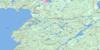
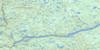
041N05 Lighthouse Island Topo Map
To view this map, mouse over the map preview on the right.
You can also download this topo map for free:
041N05 Lighthouse Island high-resolution topo map image.
Maps for the Lighthouse Island topo map sheet 041N05 at 1:50,000 scale are also available in these versions:
Lighthouse Island Surrounding Area Topo Maps
 |
 |
 |
 |
 |
 |
 |
|
 |
 |
 |
|
 |
 |
© Department of Natural Resources Canada. All rights reserved.
Lighthouse Island Gazetteer
The following places can be found on topographic map sheet 041N05 Lighthouse Island:
Lighthouse Island Topo Map: Geographical areas
Thunder BayLighthouse Island Topo Map: Islands
Caribou IslandLighthouse Island
Lighthouse Island Topo Map: Lakes
Lac SupérieurLake Superior
Lighthouse Island Topo Map: Shoals
North BankNorthwest Banks
West Banks

© Department of Natural Resources Canada. All rights reserved.
