Monte Creek Topo Map Online
Download Free Topo Map Sheet 082L12 at 1:50,000 scale
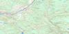
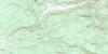
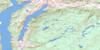
082L12 Monte Creek Topo Map
To view this map, mouse over the map preview on the right.
You can also download this topo map for free:
082L12 Monte Creek high-resolution topo map image.
Maps for the Monte Creek topo map sheet 082L12 at 1:50,000 scale are also available in these versions:
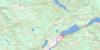
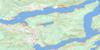
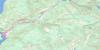
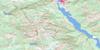
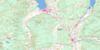
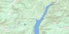
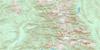
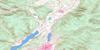
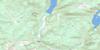
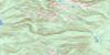
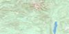
Monte Creek Surrounding Area Topo Maps
 |
 |
 |
 |
 |
 |
 |
 |
 |
 |
 |
 |
 |
 |
 |
 |
© Department of Natural Resources Canada. All rights reserved.
Monte Creek Gazetteer
The following places can be found on topographic map sheet 082L12 Monte Creek:
Monte Creek Topo Map: Capes
Lion's HeadRocky Point
Monte Creek Topo Map: Cliffs
Rocky Point BluffMonte Creek Topo Map: Geographical areas
Kamloops Division Yale Land DistrictMonte Creek Topo Map: Indian Reserves
Neskainlith Indian Reserve 2Neskonlith Indian Reserve 2
Réserve indienne Neskainlith 2
Réserve indienne Neskonlith 2
Monte Creek Topo Map: Lakes
Biancotto LakeBolean Lake
Bray Lake
Bryden Lake
Disdero Lake
Haggen Lake
Harper Lake
Joyce Lake
Little Disdero Lakes
Miller Lake
Monte Lake
Paxton Lake
Pement Lake
Pillar Lake
Pooley Lake
Ukulele Lake
Monte Creek Topo Map: Mountains
Duck HillEstekwalan Mountain
Laveau Hill
Martin Mountain
Monte Hills
Mount Chase
Mount Martin
Pemberton Hill
Ptarmigan Hills
Shuswap Highland
Whiskers Hill
Woodland Hill
Monte Creek Topo Map: Major municipal/district area - major agglomerations
Columbia-Shuswap Regional DistrictMonte Creek Topo Map: Conservation areas
Banana Island ParkMonte Creek Park
Monte Lake Park
Pritchard Park
Monte Creek Topo Map: Plains
Thompson PlateauMonte Creek Topo Map: Rivers
Arthur CreekBlair Creek
Blanc Creek
Bolean Creek
Bolean Creek
Boone Creek
Charcoal Creek
Chase Creek
Dion Creek
Disdero Creek
Dry Creek
Emil Creek
Ferris Creek
Georges Creek
Gore Creek
Harper Creek
Harrison Creek
Ivor Creek
Laveau Creek
Le Vos Creek
Mail Creek
Martin Creek
Monte Creek
Moulton Creek
Neds Creek
North Paxton Creek
Olsand Creek
Paul Creek
Paxton Creek
Pemberton Creek
Pemberton Creek
Raspberry Creek
Robbins Creek
Six Mile Creek
Skimikin Creek
South Thompson River
St. Laurent Creek
Straw Creek
Swain Creek
Teakettle Creek
Valentine Creek
Monte Creek Topo Map: Unincorporated areas
Duck MeadowDuck Range
Ducks Meadow
Falkland
Holmwood
Martin Prairie
Monte Creek
Monte Lake
Neskain
Pinantan
Pritchard
Robbins
Robbins Range
Monte Creek Topo Map: Valleys
China ValleyPaxton Valley

© Department of Natural Resources Canada. All rights reserved.
082L Related Maps:
082L Vernon082L01 Eureka Mountain
082L02 Creighton Creek
082L03 Oyama
082L04 Shorts Creek
082L05 Westwold
082L06 Vernon
082L07 Shuswap Falls
082L08 Mount Fosthall
082L09 Gates Creek
082L10 Mabel Lake
082L11 Salmon Arm
082L12 Monte Creek
082L13 Chase
082L14 Sorrento
082L15 Malakwa
082L16 Revelstoke
