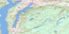
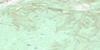
Revelstoke Topo Map Online
Download Free Topo Map Sheet 082L16 at 1:50,000 scale
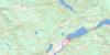
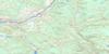
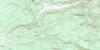
082L16 Revelstoke Topo Map
To view this map, mouse over the map preview on the right.
You can also download this topo map for free:
082L16 Revelstoke high-resolution topo map image.
Maps for the Revelstoke topo map sheet 082L16 at 1:50,000 scale are also available in these versions:
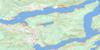
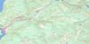
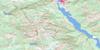
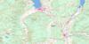
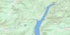
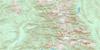
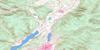
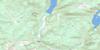
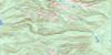
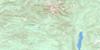
Revelstoke Surrounding Area Topo Maps
 |
 |
 |
 |
 |
 |
 |
 |
 |
 |
 |
 |
 |
 |
 |
 |
© Department of Natural Resources Canada. All rights reserved.
Revelstoke Gazetteer
The following places can be found on topographic map sheet 082L16 Revelstoke:
Revelstoke Topo Map: City
RevelstokeRevelstoke Topo Map: Cliffs
The Salmon RocksRevelstoke Topo Map: Falls
Frog FallsSutherland Falls
Revelstoke Topo Map: Islands
Beach IslandCable Island
Illecillewaet Island
Melbourne Island
Revelstoke Topo Map: Lakes
Arnica LakeBalsam Lake
Begbie Lake
Brim Lake
Clanwilliam Lake
Col Lake
Echo Lake
English Lake
Green Lake
Greenbush Lake
Griffin Lake
Heart Lake
Joss Lake
Montana Lake
Montana Slough
Revelation Lake
Scottish Lake
Surprise Lake
Three Valley Lake
Tilley Lake
Topowap Lake
Turquoise Lake
Two Moon Lake
Upper Arrow Lake
Victor Lake
Wetask Lake
Williamson Lake
Revelstoke Topo Map: Mountains
Anemone RidgeBig Bend Ranges
Blanket Mountain
Columbia Mountains
Columbia System
Davis Peak
Garnet Ridge
Ghost Peak
Ghost Rock
Gold Range
Hunters Range
Jordan Range
Joss Mountain
Mabel Range
Monashee Mountains
Mount Begbie
Mount Cartier
Mount English
Mount Mackenzie
Mount Macpherson
Mount Tilley
Sawtooth Range
Selkirk Mountains
Revelstoke Topo Map: Major municipal/district area - major agglomerations
Columbia-Shuswap Regional DistrictRevelstoke Topo Map: Conservation areas
Blanket Creek ParkBlanket Creek Recreation Area
Columbia Village Historic Park
Victor Lake Park
Revelstoke Topo Map: Recreational sites
Powder SpringsRevelstoke Topo Map: Rivers
Akolkolex RiverBegbie Creek
Blanket Creek
Bowman Creek
Bridge Creek
Columbia River
Cranberry Creek
Derry Creek
Dolan Creek
Drimmie Creek
Eagle River
Fleuve Columbia
Frog Creek
Gagney Creek
Greeley Creek
Greely Creek
Greenslide Creek
Griffith Creek
Illecillewaet River
Locks Creek
Montana Creek
Mulvehill Creek
Rutherford Creek
Scott Creek
Shuswap River
South Cranberry Creek
South Pass Creek
Tonkawatla Creek
Tonkawatla River
Victor Creek
Wap Creek
Wells Creek
Revelstoke Topo Map: Unincorporated areas
Big EddyClanwilliam
Greenslide
Mount Cartier
Three Valley
Wigwam
Revelstoke Topo Map: Valleys
Box CanyonEagle Pass
Hellebore Pass
Joss Pass

© Department of Natural Resources Canada. All rights reserved.
082L Related Maps:
082L Vernon082L01 Eureka Mountain
082L02 Creighton Creek
082L03 Oyama
082L04 Shorts Creek
082L05 Westwold
082L06 Vernon
082L07 Shuswap Falls
082L08 Mount Fosthall
082L09 Gates Creek
082L10 Mabel Lake
082L11 Salmon Arm
082L12 Monte Creek
082L13 Chase
082L14 Sorrento
082L15 Malakwa
082L16 Revelstoke
