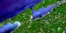
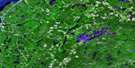
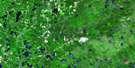
Kejimkujik Lake Satellite Image Map
Download Free Aerial Photo 021A06 at 1:50,000 scale
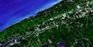
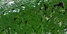
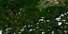
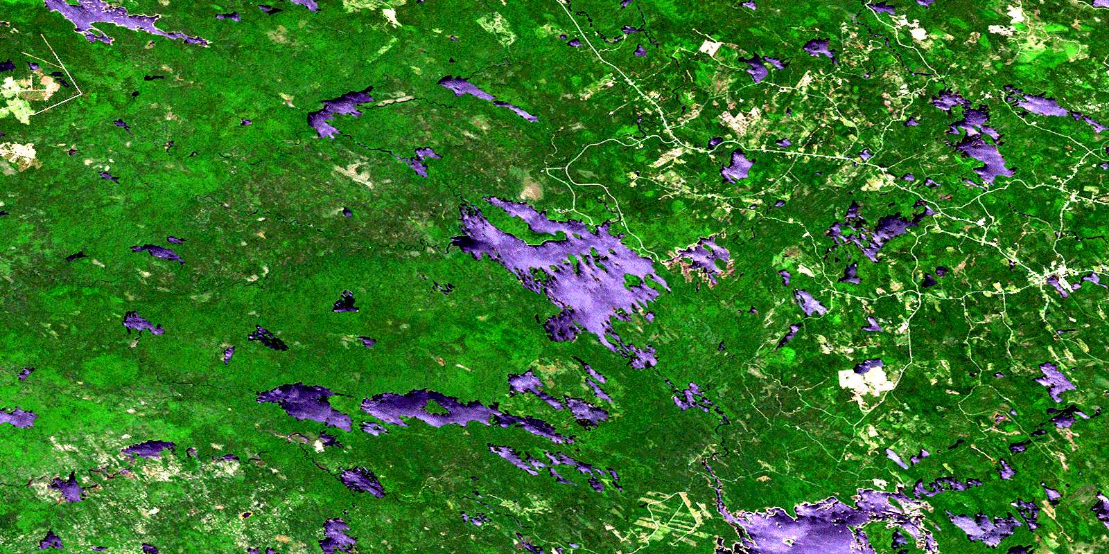
Kejimkujik Lake Satellite Imagery
To view this satellite map, mouse over the air photo on the right.
You can also download this satellite image map for free:
021A06 Kejimkujik Lake high-resolution satellite image map.
Maps for the Kejimkujik Lake aerial map sheet 021A06 at 1:50,000 scale are also available in these versions:
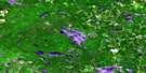
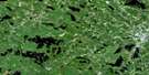
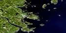
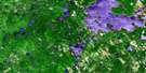
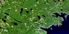
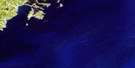
Kejimkujik Lake Surrounding Area Aerial Photo Maps
 |
 |
 |
 |
 |
 |
 |
 |
 |
 |
 |
 |
 |
 |
 |
 |
© Department of Natural Resources Canada. All rights reserved.
Kejimkujik Lake Gazetteer
The following places can be found on satellite image map 021A06 Kejimkujik Lake:
Kejimkujik Lake Satellite Image: Bays
Bull CoveCarrigan Bay
Fairbanks Bay
Fairy Bay
Gaspar Bay
Hat Cove
Honeymoon Cove
Jeremy Bay
Jeremys Bay
Lacey Bay
Low Bay
Luxie Cove
Mill Bay
Minard Bay
Minards Bay
Mount Tom Bay
Kejimkujik Lake Satellite Image: Beaches
Merrymakedge BeachSlapfoot Beach
Kejimkujik Lake Satellite Image: Capes
Cape SplitClary Point
Glode Point
Indian Point
Jim Charles Point
Jim-Charles Point
Peter Point
Rowters Point
Kejimkujik Lake Satellite Image: Channels
Eastern RunHemlock Run
The Narrows
Kejimkujik Lake Satellite Image: Falls
Dukeshires Lower FallsDukeshires Upper Falls
Granite Falls
Granite Lake Falls
Indian Falls
Kempton Falls
Loon Falls
Loon Lake Falls
Mill Falls
Poison Ivy Falls
Taylors Falls
Kejimkujik Lake Satellite Image: Geographical areas
AnnapolisDigby
Queens
Kejimkujik Lake Satellite Image: Islands
Bear IslandBig Island
Big Muise Island
Dark Island
Dukeshire Island
Ell Island
Ford Island
Forest Island
Forrest Island
Freeman Island
Glode Island
Grass Island
Hemlock Island
Hog Island
Île de l'Orignal
Isle de l'Orignal
Little Muise Island
Loon Island
McLean Island
Minard Island
Mink Island
Moose Island
Morgan Island
Norway Island
Peale Island
Richie Island
Ritchie Island
The Sisters
Kejimkujik Lake Satellite Image: Lakes
Apple Tree LakeBack Lake
Barney Lake
Barnie Lake
Beach Pond
Beaver Lake
Beaverhead Lake
Beaverskin Lake
Ben Lake
Beverley Lake
Big Dam Lake
Big Dispatch Lake
Big Red Lake
Big Rocky Lake
Bradley Lake
Bryden Lake
Bull Moose Lake
Cannon Lake
Carrigan Lake
Central Lake
Central Lake
Channel Lake
Charity Lake
Charlotte Lake
Christopher Lakes
Coblielle Lake
Cobrielle Lake
Cofan Lake
Cook Lake
Daniels Lake
Dean Lake
DeLong Lake
Dennis Boot Lake
Donnellan Lake
Duck Pond
Duck Pond Lake
Dunn Lake
East Spectacle Lakes
Eel Lake
Fairbanks Lake
Faith Lake
First Lake
Flinn Lake
Ford Lake
Fourth Christopher Lake
Freeman Lake
Frozen Ocean Lake
Frozen-ocean Lake
George Lake
Glode Lake
Gludogan Lake
Grafton Lake
Granite Lake
Harlow Lake
Harmony Lake
Harry Lake
Hen Lake
High Lake
Hilchemakaar Lake
Holdrights Lake
Hope Lake
Horseshoe Lake
House Lake
Hunt Lake
Inness Lake
Irving Lake
Joe Tom Lake
Joe-Tom Lake
Joudrey Lake
Kejimkujik Lake
Kempt Lake
Kempton Lake
Lake Franklin
Lake Mulgrave
Lake Rossignol
Lake Torment
Laurel Lake
Liberty Lake
Little Bullmoose Lake
Little Cofan Lake
Little Cook Lake
Little Despatch Lake
Little Kempton Lake
Little Liberty Lake
Little Loon Lake
Little Mud Lake
Little Peskowesk Lake
Little Red Lake
Little Rocky Lake
Loon Lake
Lower Silver Lake
Luxion Lake
Luxton Lake
Martin Lake
Mary Lake
McBride Lake
McGinty Lake
McGowan Lake
McGuire Lake
Meagher Lake
Menchan Lake
Menchan Lake
Mill Lake
Minard Lake
Mississippi Lake
Moccasin Lake
Moosehead Lake
Moosehide Lake
Morton Lake
Mount Tom Lake
Mountain Lake
Mud Lake
Mud Lake
Mud Pond
Mudflat Lake
Mulgrave Lake
Murphy Lake
North Cranberry Lake
Pat Kempton Lake
Payzant Lake
Pebbleloggitch Lake
Perch Lake
Peskawa Lake
Peskowesk Lake
Pollock Lake
Poplar Lake
Pretty Mary Lake
Puzzle Lake
Red Lake
Ring Lakes
Rocky Daniels Lake
Round Lake
Russell Lake
Sand Beach Lake
Sand Lake
Sand-beach Lake
Scott Lake
Second Christopher Lake
Second McGinty Lake
Seven Mile Lake
Siskech Lake
Snake Lake
South Mud Lake
Spar Lake
Spectacle Lake
Stave Lake
Taylors Lake
Telfer Lake
Third Christopher Lake
Torment Lake
Tupper Lake
Turnpike Lake
Turtle Lake
Twin Lakes
Two Fan Lake
Upper Silver Lake
Kejimkujik Lake Satellite Image: Mountains
Boyles HillCarrigan Hill
Douglas Hill
Mount Tom
Murphy Hill
Pat McBride Hill
Kejimkujik Lake Satellite Image: Major municipal/district area - major agglomerations
AnnapolisDigby
Queens
Kejimkujik Lake Satellite Image: Conservation areas
Annexe côtière du parc national KejimkujikKejimkujik National Historic Site of Canada
Kejimkujik National Park of Canada
Kejimkujik National Park Seaside Adjunct
Lieu historique national du Canada Kejimkujik
Parc national du Canada Kejimkujik
Tobeatic Wildlife Management Area
Kejimkujik Lake Satellite Image: Rapids
Black RattleEel Weir
Rattle Rapids
Western Run
Kejimkujik Lake Satellite Image: Rivers
Atkins BrookAtkins Meadow Brook
Back Hill Brook
Baxters Meadow Brook
Bear River
Bear River
Beaverskin Brook
Bull Moose Brook
Butler Meadow Brook
Cannon Brook
Carver Brook
Cashman Meadow Brook
Cobrielle Brook
Cole Brook
Duck Pond Brook
Flanders Meadow Brook
Fraser Brook
Frog Lake Stream
Grafton Brook
Heber Meadow Brook
Henry Brook
Inness Brook
Joudrey Brook
Lewis Brook
Liberty Brook
Little Liberty Brook
Little River
Little River
Little River
Liverpool River
London Brook
Loon Lake Stream
Lucifee Brook
Lucifer Brook
Luxion Brook
Luxton Brook
Luxtons Meadow Brook
McBride Brook
McBride Brook
Meagher Brook
Medway River
Mersey River
Mill Brook
Minard Brook
Mississippi Brook
Mississippi River
Moose Pit Brook
Moose-pit Brook
Mount Merit Brook
Mount Merrit Brook
Mount Tom Brook
Nixon Meadow Brook
North West River
Northwest Branch West River
Otter Brook
Paddy Brook
Peskowesk Brook
Porcupine Brook
Prince John Brook
Red Brook
Red Brook
Red Brook
Red Lake Brook
Rogers Brook
Shelburne River
Siskech Brook
Square Camp Brook
Stewart Brook
Still Brook
Sweeney Brook
Thomas Meadow Brook
Torment Brook
West River
Westfield River
Whiteburn Brook
Kejimkujik Lake Satellite Image: River features
Channel Lake StillwaterDukeshires Stillwater
Four Mile Stillwater
Orde Stillwater
Pebbleloggitch Stillwater
Kejimkujik Lake Satellite Image: Road features
Big Hardwood PortageCoade Carry
Kejimkujik Lake Satellite Image: Shoals
Gull RockHaystack Rock
Lantern Rock
Oak Point Ledges
Kejimkujik Lake Satellite Image: Unincorporated areas
CaledoniaHarmony Mills
Jacques Landing
Jake Landing
Jakes Landing
Kedge Lodge
Kedgemakooge
Kempt
Lakeview
Low Landing
Maitland Bridge
Meagher
Mount Merrit
New Albany
New Grafton
Northfield
Northfield Queens
West Caledonia
Westfield
Whiteburn Mines
Kejimkujik Lake Satellite Image: Low vegetation
Atkins MeadowsBurnaby Meadow
Caribou Bog
Cashman Meadows
Heber Meadows
Iles Bog
Joe Tom Bog
Lewis Meadows
Liberty Bog
Luxtons Meadow
McGinty Bog
Moosebone Bogs
Newell Bog
Snake Lake Bog
Thomas Meadows
© Department of Natural Resources Canada. All rights reserved.
021A Related Maps:
021A Annapolis Royal021A01 Lahave Islands
021A02 Liverpool
021A03 Lake Rossignol
021A04 Wentworth Lake
021A05 Weymouth
021A06 Kejimkujik Lake
021A07 Bridgewater
021A08 Lunenburg
021A09 Chester
021A10 New Germany
021A11 Milford
021A12 Digby
021A13 Granville Ferry
021A14 Bridgetown
021A15 Gaspereau Lake
021A16 Windsor
