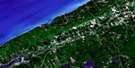
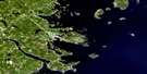
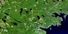
Granville Ferry Satellite Image Map
Download Free Aerial Photo 021A13 at 1:50,000 scale
Granville Ferry Satellite Imagery
To view this satellite map, mouse over the air photo on the right.
You can also download this satellite image map for free:
021A13 Granville Ferry high-resolution satellite image map.
Maps for the Granville Ferry aerial map sheet 021A13 at 1:50,000 scale are also available in these versions:
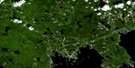
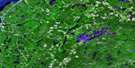
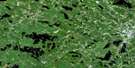
Granville Ferry Surrounding Area Aerial Photo Maps
 |
 |
 |
 |
 |
 |
 |
 |
 |
 |
 |
 |
 |
 |
 |
 |
© Department of Natural Resources Canada. All rights reserved.
Granville Ferry Gazetteer
The following places can be found on satellite image map 021A13 Granville Ferry:
Granville Ferry Satellite Image: Bays
Anderson CoveBaie de Fundy
Bay of Fundy
Bay of Fundy
Bluff Cove
Delap Cove
Delaps Cove
Litchfield Cove
Parkers Cove
Steves Cove
Granville Ferry Satellite Image: Capes
Troop PointGranville Ferry Satellite Image: Geographical areas
AnnapolisGranville Ferry Satellite Image: Military areas
Base des Forces canadiennes GreenwoodCanadian Forces Base Greenwood
Champ de tir et champ de manoeuvre Granville Ferry
Granville Ferry Range and Training Area
Granville Ferry Satellite Image: Mountains
North MountainNorth Mountain Range
Granville Ferry Satellite Image: Major municipal/district area - major agglomerations
AnnapolisGranville Ferry Satellite Image: Rivers
Anderson BrookAnnapolis River
Bohaker Brook
Bohaker Brook
Cedar Brook
Hillsburn Brook
Litchfield Brook
McCall Brook
Mill Brook
Parkers Cove Brook
Robinson Brook
Sloans Brook
Troop Brook
Worcester Brook
Granville Ferry Satellite Image: Shoals
Halftide LedgePeeps Ledge
Pollock Rock
Granville Ferry Satellite Image: Towns
Annapolis RoyalGranville Ferry Satellite Image: Unincorporated areas
Delap CoveDelaps Cove
Granville Ferry
Hillsburn
Litchfield
Parkers Cove
Granville Ferry Satellite Image: Valleys
Annapolis ValleyGranville Ferry Satellite Image: Low vegetation
Uncle Freds Meadow
© Department of Natural Resources Canada. All rights reserved.
021A Related Maps:
021A Annapolis Royal021A01 Lahave Islands
021A02 Liverpool
021A03 Lake Rossignol
021A04 Wentworth Lake
021A05 Weymouth
021A06 Kejimkujik Lake
021A07 Bridgewater
021A08 Lunenburg
021A09 Chester
021A10 New Germany
021A11 Milford
021A12 Digby
021A13 Granville Ferry
021A14 Bridgetown
021A15 Gaspereau Lake
021A16 Windsor
