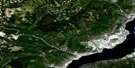
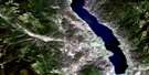
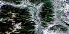
Christian Valley Satellite Image Map
Download Free Aerial Photo 082E10 at 1:50,000 scale
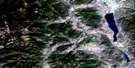
Christian Valley Satellite Imagery
To view this satellite map, mouse over the air photo on the right.
You can also download this satellite image map for free:
082E10 Christian Valley high-resolution satellite image map.
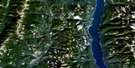
Maps for the Christian Valley aerial map sheet 082E10 at 1:50,000 scale are also available in these versions:
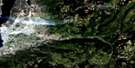
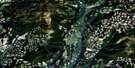
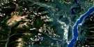
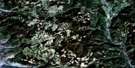
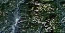
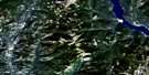
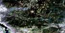
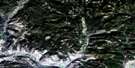
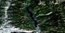
Christian Valley Surrounding Area Aerial Photo Maps
 |
 |
 |
 |
 |
 |
 |
 |
 |
 |
 |
 |
 |
 |
 |
 |
© Department of Natural Resources Canada. All rights reserved.
Christian Valley Gazetteer
The following places can be found on satellite image map 082E10 Christian Valley:
Christian Valley Satellite Image: Lakes
Buck LakeClark Lake
Clear Lake
Collier Lake
Copperkettle Lake
Cup Lake
Joan Lake
Lassie Lake
Little Sandrift Lake
Maloney Lake
Martin Lake
Sandrift Lake
South Sandrift Lake
State Lake
Upper Collier Lake
Christian Valley Satellite Image: Mountains
Arthurs MountainBeaverdell Range
Big White Mountain
Bluejoint Mountain
China Ridge
Christina Range
Columbia Mountains
Crystal Butte
Crystal Mountain
Finlayson Ridge
Lake Ridge
Midway Mountains
Midway Range
Monashee Mountains
Mosher Ridge
Mount Arthurs
Mount Cochrane
Mount Noren
Mount Tanner
Mount Wallace
Okanagan Highland
St. John Ridge
Christian Valley Satellite Image: Major municipal/district area - major agglomerations
Regional District of Central KootenayRegional District of Kootenay-Boundary
Christian Valley Satellite Image: Conservation areas
Granby ParkChristian Valley Satellite Image: Plains
Interior PlateauChristian Valley Satellite Image: Rivers
Arthurs CreekBarth Creek
Beaverdell Creek
Birched Creek
Cane Creek
Carmi Creek
China Creek
Cochrane Creek
Copperkettle Creek
Crystal Creek
Damfino Creek
Dear Creek
Goatskin Creek
Granby River
Grano Creek
Hellroarer Creek
Kettle River
Maloney Creek
McElroy Creek
Mosher Creek
Nevertouch Creek
Rendell Creek
Sago Creek
Sandrift Creek
Spout Creek
St. John Creek
State Creek
Trapper Creek
Trapping Creek
Traverse Creek
Whitefoot Creek
Christian Valley Satellite Image: Unincorporated areas
Big WhiteChristian Valley

© Department of Natural Resources Canada. All rights reserved.
082E Related Maps:
082E Penticton082E01 Grand Forks
082E02 Greenwood
082E03 Osoyoos
082E04 Keremeos
082E05 Penticton
082E06 Beaverdell
082E07 Almond Mountain
082E08 Deer Park
082E09 Burrell Creek
082E10 Christian Valley
082E11 Wilkinson Creek
082E12 Summerland
082E13 Peachland
082E14 Kelowna
082E15 Damfino Creek
082E16 Edgewood
