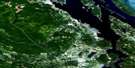
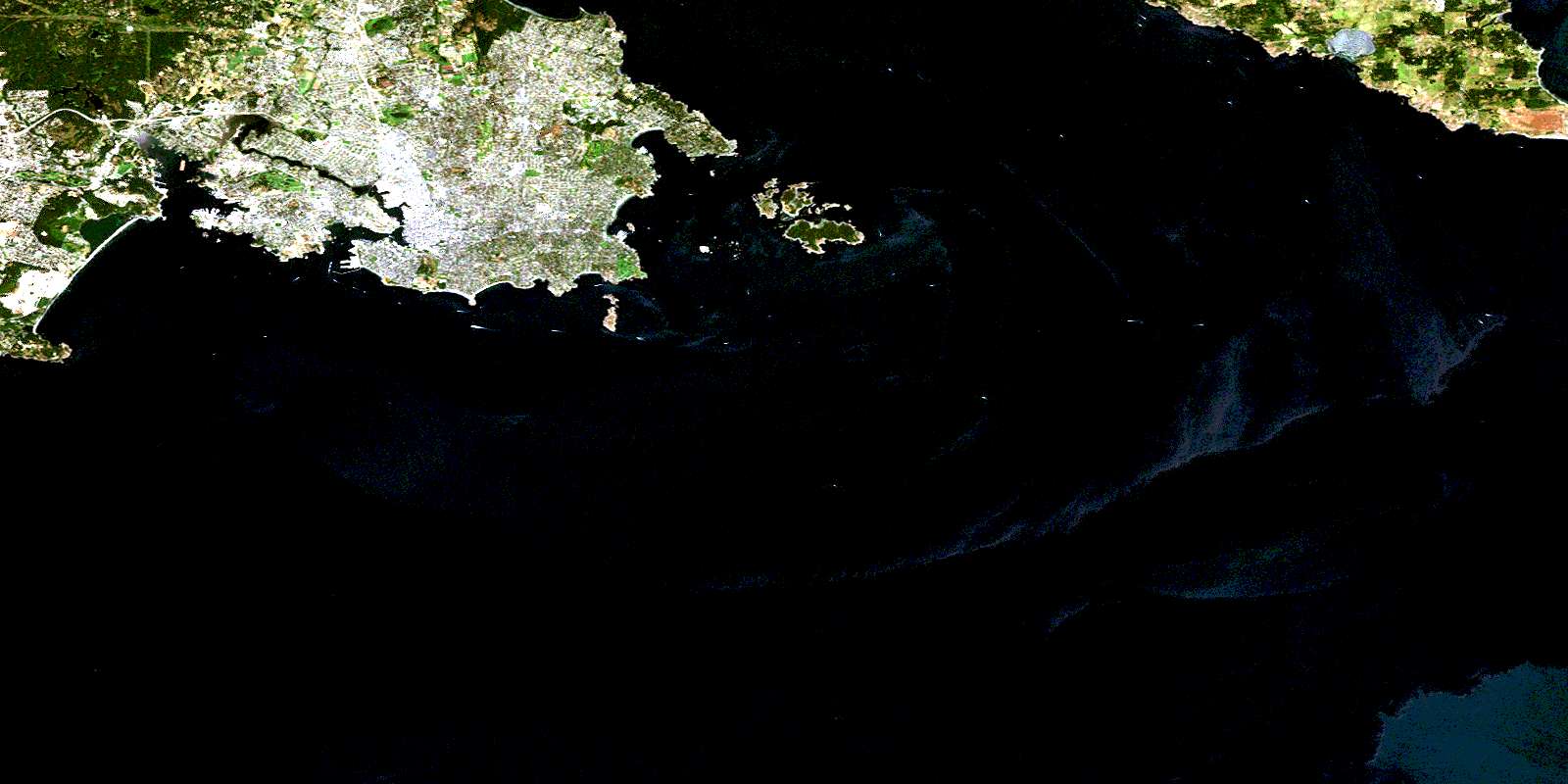
Victoria Satellite Image Map
Download Free Aerial Photo 092B06 at 1:50,000 scale
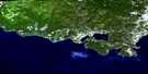
Victoria Satellite Imagery
To view this satellite map, mouse over the air photo on the right.
You can also download this satellite image map for free:
092B06 Victoria high-resolution satellite image map.
Maps for the Victoria aerial map sheet 092B06 at 1:50,000 scale are also available in these versions:
Victoria Surrounding Area Aerial Photo Maps
 |
 |
||
 |
 |
||
 |
 |
||
© Department of Natural Resources Canada. All rights reserved.
Victoria Gazetteer
The following places can be found on satellite image map 092B06 Victoria:
Victoria Satellite Image: Bays
Arbutus CoveCadboro Bay
Constance Cove
Cordova Bay
Dunns Nook
Esquimalt Harbour
Finnerty Cove
Fleming Bay
Flotsam Cove
Foul Bay
Funnel Cove
Glencoe Cove
Gonzales Bay
Gorge Waters
Helmcken Cove
Inner Harbour
Inspiration Cove
James Bay
Lang Cove
Lime Bay
Limekiln Cove
Loon Bay
Margaret Bay
Maynard Cove
McNeill Bay
Oak Bay
Parry Bay
Pilgrim Cove
Plumper Bay
Portage Inlet
Price Bay
Puget Cove
Rock Bay
Rose Bay
Ross Bay
Royal Roads
Rudlin Bay
Selkirk Water
Sheep Cove
Spoon Bay
St. Margaret Bay
Telegraph Cove
Thetis Cove
Tovey Bay
Upper Harbour
Vantreight Cove
Victoria Harbour
West Bay
Victoria Satellite Image: Beaches
Willows BeachVictoria Satellite Image: Capes
Aaron PointAlbert Head
Ashe Head
Barclay Point
Black Rock
Cadboro Point
Camel Point
Cape Saxe
Cattle Point
Channel Point
Chapman Point
Christie Point
Clover Point
Coburg Peninsula
Coffin Island Point
Commodore Point
Cormorant Point
Duntze Head
Dyke Point
Finlayson Point
Flamborough Head
Foul Point
Gonzales Point
Gordon Head
Gotha Point
Halkett Head
Harling Point
Heritage Point
Holland Point
Hope Point
Laurel Point
Limit Point
Macaulay Point
Maple Point
McLoughlin Point
McMicking Point
Munroe Head
Ogden Point
Paterson Point
Point Ellice
Raymur Point
Rodd Point
Royal Point
Saanich Peninsula
Saxe Point
Sea Bird Point
Seabird Point
Ship Point
Shoal Point
Skegness
Songhees Point
Spurn Head
Staines Point
Ten Mile Point
The Naze
Turkey Head
Wark Point
Work Point
Yew Point
Victoria Satellite Image: Channels
Baynes ChannelEnterprise Channel
Haro Strait
Hecate Passage
Juan de Fuca Strait
Mayor Channel
Mouat Channel
Paddy Passage
Plumper Passage
The Gorge
Victoria Satellite Image: City
ColwoodLangford
Victoria
Victoria Satellite Image: Cliffs
Dallas BankVictoria Satellite Image: District municipality
EsquimaltHighlands
Metchosin
Oak Bay
Saanich
Victoria Satellite Image: Geographical areas
Cowichan Land DistrictEsquimalt Land District
Highland Land District
Lake Land District
Victoria Land District
Victoria Satellite Image: Indian Reserves
Chatham Islands Indian Reserve 4Discovery Island Indian Reserve 3
Esquimalt Indian Reserve
New Songhees Indian Reserve 1A
Réserve indienne Chatham Islands 4
Réserve indienne Discovery Island 3
Réserve indienne Esquimalt
Réserve indienne New Songhees 1A
Victoria Satellite Image: Islands
Alpha IsletBerens Island
Brothers Islands
Chain Islets
Chatham Islands
Coffin Island
Cole Island
Colvile Island
Colville Island
Discovery Island
Emily Islet
Evans Island
Fisgard Island
Flower Island
Gillingham Islands
Great Chain Island
Griffin Island
Halkett Island
Harris Island
Harrison Island
Île de Vancouver
Inskip Islands
Jemmy Jones Island
Kitty Islet
Macarthy Island
Mary Tod Island
McCarthy Island
Pelly Island
Richards Island
Smart Island
Staines Island
Strongtide Islet
Trial Islands
Vancouver Island
Vantreight Island
Work Island
Victoria Satellite Image: Lakes
Albert Head LagoonBeckwith Pond
Blenkinsop Lake
Colwood Lake
Esquimalt Lagoon
Goodacre Lake
Maltby Lake
McKenzie Lake
Pike Lake
Prior Lake
Swan Lake
Thetis Lake
Trevlac Pond
Victoria Satellite Image: Military areas
Albert Head Battery Point Training AreaBase des Forces canadiennes Esquimalt
Canadian Forces Base Esquimalt
Champ de manoeuvre Albert Head Battery Point
Victoria Satellite Image: Mountains
Anderson HillBeacon Hill
Christmas Hill
Golf Hill
Gonzales Hill
Gowlland Range
Grant Knoll
Highrock
Knockan Hill
Mill Hill
Mount Douglas
Mount Tolmie
Pandora Hill
Peacock Hill
Prevost Hill
Rodd Hill
Scafe Hill
Seymour Hill
Signal Hill
Smith Hill
Victoria Satellite Image: Major municipal/district area - major agglomerations
Capital Regional DistrictVictoria Satellite Image: Conservation areas
Discovery Island Marine ParkEsquimalt Lagoon Bird Sanctuary
Fisgard Lighthouse National Historic Site of Canada
Fort Rodd Hill National Historic Park
Fort Rodd Hill National Historic Site of Canada
Freeman King Park
Helmcken Centennial Park
Lieu historique national du Canada du Fort Rodd Hill
Lieu historique national du Canada du Phare-de-Fisgard
Newstead Park
Parc historique national du Fort-Rodd Hill
Refuge d'oiseaux d'Esquimalt-Lagoon
Refuge d'oiseaux du havre de Victoria
Thomas S. Francis Park
Victoria Harbour Bird Sanctuary
Victoria Satellite Image: Plains
Panama FlatsVictoria Satellite Image: Provinces
British ColumbiaColombie-Britannique
Victoria Satellite Image: Rivers
Bowker CreekColquitz River
Colwood Creek
Craigflower Creek
Deadman Creek
Mill Stream
Swan Lake Creek
Trevlac Brook
Viaduct Creek
Victoria Satellite Image: Shoals
Beaumont ShoalBrinn Rock
Brodie Rock
Brotchie Ledge
Carolina Reef
Caroline Reef
Coghlan Rock
Constance Bank
Discovery Rock
Evans Rock
Fiddle Reef
Fulford Reef
Glimpse Reefs
Gordon Rock
Johnstone Reef
Johnstone Rock
Lee Rock
Lewis Reef
Malacca Patch
Mouat Reef
Robson Reef
Scrogg Rocks
Scroggs Rocks
Sister Rocks
Sleeper Rock
Spencer Ledge
Templar Rock
Thames Shoal
Tod Rock
Tuzo Rock
Village Rocks
Virtue Rock
Whale Rock
Victoria Satellite Image: Towns
View RoyalVictoria Satellite Image: Unincorporated areas
AdmiralsAdmirals Road
Albert Head
Alpha Street
Beaumont
Belmont Park
Cadboro Bay
Colquitz
Craigflower
Esquimalt
Esquimalt Siding
Fairfield
Glyn
Gordon Head
James Bay
Lagoon
Lake Hill
Langford Station
Marigold
Mount Tolmie
Mount Tolmie
Palmer
Royal Oak
Russells
Sevenoaks
Strawberry Vale
Thoburn
Tillicum
Wye
Victoria Satellite Image: Low vegetation
Quicks BottomRithets Bog
© Department of Natural Resources Canada. All rights reserved.
