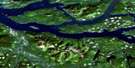
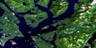
Stafford River Satellite Image Map
Download Free Aerial Photo 092K14 at 1:50,000 scale
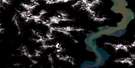
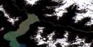
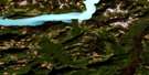
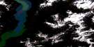
Stafford River Satellite Imagery
To view this satellite map, mouse over the air photo on the right.
You can also download this satellite image map for free:
092K14 Stafford River high-resolution satellite image map.
Maps for the Stafford River aerial map sheet 092K14 at 1:50,000 scale are also available in these versions:
Stafford River Surrounding Area Aerial Photo Maps
 |
 |
 |
 |
 |
 |
 |
 |
 |
 |
 |
 |
 |
 |
 |
 |
© Department of Natural Resources Canada. All rights reserved.
Stafford River Gazetteer
The following places can be found on satellite image map 092K14 Stafford River:
Stafford River Satellite Image: Bays
Knight InletStafford River Satellite Image: Lakes
Bodil LakeStafford Lake
Stafford River Satellite Image: Mountains
Chaîne CôtièreCoast Mountains
Cumsack Mountain
Mount Cridge
Mount Dundas
Mount Henry
Mount Lang
Mount Smith
Pacific Ranges
Whitemantle Range
Stafford River Satellite Image: Major municipal/district area - major agglomerations
Regional District of Comox-StrathconaRegional District of Mount Waddington
Stafford River Satellite Image: Rivers
Apple RiverBear River
Cridge Creek
Four Mile Creek
Mellersh Creek
Phillips River
Smith Creek
Stafford River
Wahkash Creek
© Department of Natural Resources Canada. All rights reserved.
092K Related Maps:
092K Bute Inlet092K01 Powell Lake
092K02 Desolation Sound
092K03 Quadra Island
092K04 Brewster Lake
092K05 Sayward
092K06 Sonora Island
092K07 Toba Inlet
092K08 Little Toba River
092K09 Mount Argyll
092K10 Orford River
092K11 Phillips River
092K12 Glendale Cove
092K13 Knight Inlet
092K14 Stafford River
092K15 Southgate River
092K16 Mount Gilbert
