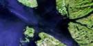
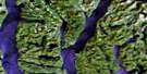
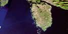
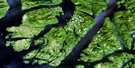
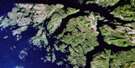
Bella Bella Satellite Image Map
Download Free Aerial Photo 103A01 at 1:50,000 scale
Bella Bella Satellite Imagery
To view this satellite map, mouse over the air photo on the right.
You can also download this satellite image map for free:
103A01 Bella Bella high-resolution satellite image map.
Maps for the Bella Bella aerial map sheet 103A01 at 1:50,000 scale are also available in these versions:
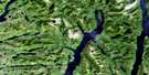
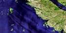
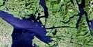
Bella Bella Surrounding Area Aerial Photo Maps
 |
 |
 |
 |
 |
 |
 |
|
 |
 |
 |
|
 |
© Department of Natural Resources Canada. All rights reserved.
Bella Bella Gazetteer
The following places can be found on satellite image map 103A01 Bella Bella:
Bella Bella Satellite Image: Air navigation features
Bella BellaBella Bella Satellite Image: Bays
Ada CoveAlarm Cove
Ardmillan Bay
Bob Bay
Canal Bight
Cavin Cove
Cooper Inlet
Cundall Bay
Donkey Cove
Dundivan Inlet
Dyer Cove
Fancy Cove
Fancy Creek
Fannie Cove
Hochstader Basin
Jane Cove
Jane Creek
Kakushdish Harbour
Kliktsoatli Harbour
Kynumpt Harbour
Lizzie Cove
Lockhart Bay
Louisa Cove
Martins Cove
McLoughlin Bay
Norman Morison Bay
Odin Cove
Ormidale Harbour
Peter Bay
Raven Cove
St. John Harbour
Strom Cove
Thompson Bay
Whisky Cove
Bella Bella Satellite Image: Capes
Archibald PointAtli Point
Beak Point
Beeton Point
Calver Point
Cape Mark
Cape Swaine
Charles Point
Cheney Point
Christiansen Point
Cone Point
Cree Point
Danger Point
Defeat Point
Denniston Point
Dryad Point
Dumas Point
Edwards Point
Farmer Point
Fingal Point
German Point
Gertrude Point
Gibson Point
Green Neck
Harbourmaster Point
Hibbard Point
Hose Point
Idol Point
Isabel Point
Kimlock Point
Kingscote Point
Kingsley Point
Kintail Point
Lay Point
Manson Point
McGown Point
Munsie Point
Napier Point
Noon Point
Penny Point
Quinoot Point
Reba Point
Redford Point
Robins Point
Shelf Point
Soulsby Point
Spire Point
Spratt Point
Story Point
Strom Point
Townsend Point
Twilight Point
Westminster Point
Bella Bella Satellite Image: Channels
Boddy NarrowsBoddy Passage
Brown Narrows
Clayton Passage
Codfish Passage
Gale Passage
Golby Passage
Gunboat Passage
Hunter Channel
Joassa Channel
Lama Passage
Louise Channel
Milbanke Sound
Queens Sound
Rait Narrows
Raymond Passage
Return Channel
Safe Passage
Seaforth Channel
Tide Rip Passage
Tiderip Passage
Troup Passage
Waskesiu Passage
Wheelock Passage
Bella Bella Satellite Image: Cliffs
Cliff BluffBella Bella Satellite Image: Indian Reserves
Bella Bella Indian Reserve 1Howeet Indian Reserve 8
Island Indian Reserve 14A
Kajustus Indian Reserve 10
'Kluémt 15
'Kluémt Indian Reserve 15
Koqui Indian Reserve 6
Kunsoot Indian Reserve 9
Pole Island Indian Reserve 14
Réserve indienne Bella Bella 1
Réserve indienne Howeet 8
Réserve indienne Island 14A
Réserve indienne Kajustus 10
Réserve indienne 'Kluémt 15
Réserve indienne Koqui 6
Réserve indienne Kunsoot 9
Réserve indienne Pole Island 14
Réserve indienne Tcimotf 1A
Tcimotf Indian Reserve 1A
Bella Bella Satellite Image: Islands
Active IsletAdmiral Group
Agnew Islet
Alert Island
Alleyne Island
Ark Island
Athabaskan Island
Athlone Island
Bardswell Group
Bardswell Islands
Bark Island
Bay Island
Beak Island
Beazley Islands
Beech Islet
Bella Bella Islands
Brodeur Island
Broken Group
Camp Island
Campbell Island
Chatfield Island
Check Island
Clarie Island
Creery Islands
Cunningham Island
Cypress Island
Dearth Island
Denny Island
DeWolf Island
Dobbs Islets
Dodwell Island
Dufferin Island
End Island
Ferrie Island
Fingal Island
Goose Group
Goose Island
Gow Island
Gus Island
Haida Islands
Handyside Island
Hart Island
Horsfall Island
Houghton Islands
Hunter Island
Huron Island
Iroquois Island
James Island
Jones Island
Klik Island
Lang Island
Lenz Islet
Limit Island
Mallory Islands
Matilda Island
McMullen Group
McMullin Group
Meadow Island
Miles Island
Mouse Island
Mouse Islets
Muir Island
Nelles Island
Nevay Island
Newby Island
Nose Island
Oland Islet
Pear Island
Piddington Island
Pole Island
Poole Islet
Potts Island
Prince Group
Princess Alice Island
Pullen Island
Raby Islet
Rainbow Island
Reginald Island
Rithet Island
Sabiston Island
Saunders Island
Seen Island
Shearwater Island
Shot Island
Song Island
Spirit Island
Stryker Island
Thorburne Island
Tribal Group
Tuft Islands
Walker Island
Want Island
Wood Island
Wurtele Island
Yates Island
Bella Bella Satellite Image: Lakes
Bishop LakeCroil Lake
Eddie Lake
Marie Lake
McLoughlin Lake
Swannell Lake
Woods Lake
Yaaklele Lagoon
Bella Bella Satellite Image: Mountains
Mount GowllandMount Hand
Mount Verney
Verney Mountain
Williams Mountains
Williams Range
Bella Bella Satellite Image: Major municipal/district area - major agglomerations
Central Coast Regional DistrictBella Bella Satellite Image: Conservation areas
Hakai Recreation AreaBella Bella Satellite Image: Rivers
Fancy CreekFannie Creek
Jane Creek
Kunsoot River
Kwakiutl Creek
Lockhart Creek
McLoughlin Creek
Scribner Creek
Wahgilah Creek
Bella Bella Satellite Image: Shoals
Bay RocksBird Rock
Blow Reef
Bourke Rock
Dall Rocks
David Ledge
Edge Reef
Emmaline Bank
Fingal Ledges
Gale Rock
Godfrey Rock
Guano Rocks
Henry Rock
Hodges Reef
Hogan Rock
Hope Rocks
Marshall Reef
Mohun Shoal
Murray Shoals
Peveril Rock
Rage Reefs
Regatta Rocks
Rudge Rock
Tingley Rock
Welch Rock
Wellington Rock
Weyburn Rock
Bella Bella Satellite Image: Unincorporated areas
Bella BellaBella Bella
Bella Bella
Bella Bella
Bellabella
Bellabella
Campbell Island
New Bella Bella
Old Bella Bella
Shearwater
Waglisla

© Department of Natural Resources Canada. All rights reserved.
