Chronicle Island Topo Map Online
Download Free Topo Map Sheet 014C10 at 1:50,000 scale
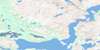
014C10 Chronicle Island Topo Map
To view this map, mouse over the map preview on the right.
You can also download this topo map for free:
014C10 Chronicle Island high-resolution topo map image.
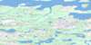
Maps for the Chronicle Island topo map sheet 014C10 at 1:50,000 scale are also available in these versions:
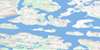
Chronicle Island Surrounding Area Topo Maps
 |
 |
 |
|
 |
 |
 |
|
 |
 |
 |
|
 |
 |
 |
© Department of Natural Resources Canada. All rights reserved.
Chronicle Island Gazetteer
The following places can be found on topographic map sheet 014C10 Chronicle Island:
Chronicle Island Topo Map: Bays
Indian CoveChronicle Island Topo Map: Islands
Calf Cow and Bull IslandsChronicle Island
Cow and Bull Islands Calf
Dawes Islands
Gull Islands
Indian Island
Inuchulik Island
Koliktalik Island
Leeder Island
Marshall Island
Monk Island
Saint Johns Island
Savage Islands
Uiraluk Island
Wood Island
Chronicle Island Topo Map: Seas
Mer du LabradorChronicle Island Topo Map: Shoals
Fairway RockFripp Rock
Hampson Rocks
Hen and Chickens

© Department of Natural Resources Canada. All rights reserved.
