Bridgewater Topo Map Online
Download Free Topo Map Sheet 021A07 at 1:50,000 scale
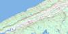
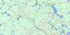
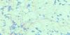
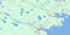
021A07 Bridgewater Topo Map
To view this map, mouse over the map preview on the right.
You can also download this topo map for free:
021A07 Bridgewater high-resolution topo map image.
Maps for the Bridgewater topo map sheet 021A07 at 1:50,000 scale are also available in these versions:
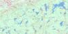
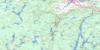
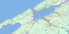
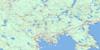
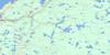
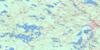
Bridgewater Surrounding Area Topo Maps
 |
 |
 |
 |
 |
 |
 |
 |
 |
 |
 |
 |
 |
 |
 |
 |
© Department of Natural Resources Canada. All rights reserved.
Bridgewater Gazetteer
The following places can be found on topographic map sheet 021A07 Bridgewater:
Bridgewater Topo Map: Bays
Ballou CoveBear Cove
Beavertail Basin
Big Sixteen Mile Bay
Canoe Cove
Cow Moose Bay
Demone Cove
Desmond Cove
Doyles Cove
Feener Cove
Keddy Cove
Little Sixteen Mile Bay
Long Cove
McLean Cove
Mill Cove
Northwest Cove
Salmon Bay
Smokepipe Cove
St. Mary Bay
Bridgewater Topo Map: Beaches
Molega BeachBridgewater Topo Map: Capes
Aulenbach PointBaker Point
Ballou Point
County Line Point
Faulkners Point
Forest Point
Grassy Point
Handley Point
Hanley Point
Henry Neck
Kaulbacks Peninsula
Maplesue Point
McLean Neck
Norway Point
Piney Point
Ponhook Points
Ponhook Rim
Red Hill Point
Rose Lead Point
The Peninsula
Turtle Head
Uhlman Point
Bridgewater Topo Map: Channels
The NarrowsThe Narrows
The Pinchgut
The S
Bridgewater Topo Map: Falls
Archies FallsBig Tumbling Falls
Cooks Falls
Darrs Falls
Frideaux Falls
Glode Falls
Glodes Falls
Hirtles Falls
Island Falls
Keddy Falls
Lake Pool Falls
Little Tumbling Falls
Long Falls
Mill Pool Falls
Mountain Falls
Sholds Dam Falls
The Mill Privilege Falls
Turn of the River Falls
Wentzells Falls
Wildcat Fall
Wildcat Falls
Zinck Spout
Bridgewater Topo Map: Geographical areas
LunenburgQueens
Bridgewater Topo Map: Indian Reserves
Medway River 11Wildcat 12
Bridgewater Topo Map: Islands
Big Brother IslandBig Glode Island
Big La Mouna Island
Birch Island
Birch Island
Bird Island
Brandy Island
Broom Island
Bruhm Island
Cow Island
Cranberry Island
Dauphinees Island
Eds Island
Governors Island
Grassy Island
Hines Island
Hunt Island
Jasons Island
Little Brother Island
Little Glode Island
Little La Mouna Island
Loon Island
Moore Island
Moose Island
Oickle Island
Owen Island
Partridge Island
Petton Island
Rocksway Island
Rocksway Island
Round Island
Round Islands
Silver Island
Slaughenwhite Island
Softwood Island
Spruce Island
Survey Island
Turner Island
Bridgewater Topo Map: Lakes
Andrew LakeAnkle Jack Lake
Annis Lake
Ashland Lake
Baker Lake
Beartrap Lake
Beaver Lake
Beaverdam Lake
Beavertail Lake
Big Mushamush Lake
Big Winnifred Lake
Black Rattle Lake
Blysteiner Lake
Branch Lake
Bruhm Lake
Bruhms Lake
Bull Moose Lake
Burnt Lake
Cameron Lake
Caribou Lake
Christopher Lakes
Cobbles Cove
Collins Lake
Cook Lake
Cooks Lake
Cow Moose Lake
Cow Moose Lake
Cranberry Lake
Cranberry Lake
Cranberry Lake
Crooked Lake
Demone Lake
Elizabeth Lake
Fancy Lake
Fancy Lake
Faulkner Lake
Fire Lake
First Christopher Lake
Fish Weir Lake
Fisher Lake
Fitch Little Lake
Fitch Long Lake
Fox Lake
Frank Lake
Frederick Lake
Garber Lake
Grant Lake
Harley Lake
Haynes Pond
Hebb Lake
Hebb Mill Pond
Hen Lake
Hen Lake
Hirtle Lake
Hog Lake
Horse Lake
Horseshoe Lake
Huey Lake
Irwin Lake
Island Lake
Johns Pond
Lake Rossignol
Leipsigate Lake
Lewie Lake
Little Beaver Lake
Little Cooks Lake
Little Hog Lake
Little Lake
Little Marsh Lake
Little Moose Lake
Little Moosehorn Lake
Little Mushamush Lake
Little Ponhook Lake
Little Tupper Lake
Little Wentworth Lake
Little Wiles Lake
Little Winnifred Lake
Lohnes Lake
Long Lake
Mack Lake
Mader Lake
Maders Lake
Malaga Lake
Marsh Lake
Matthew Lake
Milipsigate Lake
Minamkeak Lake
Molega Lake
Moose Lake
Moosehorn Lake
Mud Lake
Mud Lake
Mushamush Lake
New Canada Lake
Newcombe Lake
Newy Lake
Oak Hill Lake
Oakhill Lake
Oickle Lake
Oickle Lake
Patrick Lake
Pinegrove Lake
Ponhook Lake
Potter Lake
Prescott Lake
Publicover Lake
Randall Lake
Rebeccas Lake
Rhodenizer Lake
Rhyno Lake
Rhyno Lake
Rocky Lake
Rocky Lake
Rocky Lake
Rodenhiser Lake
Round Lake
Sarty Lake
Seamore Lake
Second Christopher Lake
Seven Mile Lake
Shingle Lake
Slauenwhite Lake
Smeltzer Pond
Smith Lake
South Mud Lake
Spectacle Lake
Spectacle Lakes
St. George Lake
Sucker Lake
Sugar Lake
The Lagoon
Town Pond
Tupper Lake
Tupper Long Lake
Upper Salter Lake
Upper Salters Lake
Wagner Lake
Wagner Lake
Wallace Lake
Watermans Lake
Weagle Lake
Weazle Lake
Wentworth Lake
Wentzell Lake
Wentzells Lake
Whitman Pond
Whynott Lake
Wiles Lake
Wiles Lake
Woolenhaupt Lake
Woolenhopp Lake
Wynot Lake
Bridgewater Topo Map: Mountains
Birch Tree HillButler Hill
Church Hill
Colpitt Hill
Cross Hill
Fitch Hill
Nauglers Hill
Oak Hill
Red Hill
Rixon Hill
Schoolhouse Hill
Bridgewater Topo Map: Major municipal/district area - major agglomerations
LunenburgQueens
Bridgewater Topo Map: Conservation areas
Camerons Brook Provincial ParkFancy Lake Provincial Park
Wentzells Lake Provincial Park
Bridgewater Topo Map: Rapids
Black RattleBlack Rattle
Bridgewater Topo Map: Rivers
Ash BrookBack Hill Brook
Barren Meadow Brook
Bear Brook
Beartrap Brook
Beaver Brook
Big Ward Brook
Birch Brook
Black Brook
Boggy Hole Brook
Brady Brook
Bradys Mill Brook
Brandy Brook
Browns Brook
Buggy Hole Brook
Bull Moose Brook
California Brook
Cook Brook
Cooks Brook
Cunningham Brook
Dauphinees Run
Dean Brook
Deep Brook
Demones Run
Dexter Brook
Dexter Run
Doyles Cove Brook
Eighteen Mile Brook
Eighteenmile Brook
Falls Luck Brook
Faulkenham Brook
Faulkner Lake Mill Brook
Feener Brook
Fifteen Mile Brook
Fire Brook
Fish Weir Brook
Fitch Brook
Fivepound Brook
Goodwater Brook
Grouse Brook
Halfway Brook
Hanley Brook
Harley Lake Mill Brook
Hebb Brook
Hebb Mill Brook
Heckman Brook
Hog Lake Meadow Brook
Huey Brook
Humtagut Creek
Humtagut Creek
Joudrey Brook
Keddy Brook
Kedron Brook
King Brook
La Have River
LaBelle Brook
Lahave River
LaHave River
Little Ward Brook
Long Cove Brook
Mailman Brook
Marsh Brook
McLean Brook
Meadow Brook
Meadow Brook
Meagher Brook
Medway River
Mill Brook
Mill Brook
Minamkeak Brook
Mint Brook
Moosehorn Brook
Mushamush River
Newcombe Brook
North Branch Lahave River
North Branch LaHave River
North La Have River
North Lahave River
Number Two Brook
Oak Run
Oakes Mill Brook
Oickle Brook
Petite Rivière
Pleasant River
Rebecca Brook
Rhodenizer Brook
Rocky Lake Brook
Round Lake Brook
Salter Brook
Salters Brook
Sandy Brook
Shinglemill Brook
Silver Mill Brook
Smith Brook
Smith Meadow Brook
Still Brook
Stuart Brook
Sucker Brook
Swamp Brook
Tait Run
Turtle Brook
Veinot Brook
Verge Brook
Wallace Brook
West La Have River
West Lahave River
West LaHave River
Westfield River
White Rocks Run
Wildcat Brook
Wildcat River
Wiles Brook
Zwicker Brook
Bridgewater Topo Map: River features
Amos StillwaterBig Rock Pool
Black Rattle Stillwater
Bruhms Bridge Pool
Clay Bank Pool
Cooks Falls Pool
Dauphinees Island Pool
Eel Weir Pool
Eel Weir Stillwater
Fire Pool
Frideaux Pool
Grassy Island Pool
Hall Pool
Hirtles Mill Pool
Johnnys Hole
Keddy Falls Pool
Lake Pool
Lennys Hole
Line Fence Pool
Mailmans Pool
McDonalds Cabin Pool
Mill Pool
Millys Bend
Railway Bridge Pool
Sarty Pool
Schoolhouse Pool
Stump Pool
The Bend of the River Pool
The Dump
The Ox Bow
The Piers Pool
The Sheerdam Pool
Veinots Pool
Wentzells Falls Pool
Bridgewater Topo Map: Shoals
The ShoalsBridgewater Topo Map: Towns
BridgewaterBridgewater Topo Map: Unincorporated areas
AuburndaleBaker Settlement
Bakers Settlement
Branch La Have
Branch LaHave
Branch Lahave
Brookfield Mines
Buckfield
Camperdown
Chelsea
Colpton
Conquerall
Conquerall Mills
Cookville
East Clifford
Feeners Corner
Feener's Corner
Greenfield
Hebbs Cross
Hibernia
Italy Cross
LaBelle
Laconia
Lapland
Lower Branch
Lower Northfield
Malaga Gold Mines
Middle New Cornwall
Midville Branch
Molega
Molega North
Mossman
Mossman
Mossman Corner
Mossman Grant
New Canada
New Elm
Newcombe
Newcombville
Nineveh
North Brookfield
Northfield
Oak Hill
Oakhill
Pine Grove
Pinehurst
Pleasant River
Sebastopol
South Brookfield
Sweetland
Upper Branch
Upper Chelsea
Upper Northfield
Waterloo
Wellington
Wentzells Lake
Wentzell's Lake
West Clifford
West Northfield
West Northfield
Wileville
Bridgewater Topo Map: Low vegetation
Big Ward Brook MeadowDarrs Marsh
Eighteen Mile Meadows
Fancy Meadow
Smith Lake Bog
Bridgewater Topo Map: Villages
Hebbville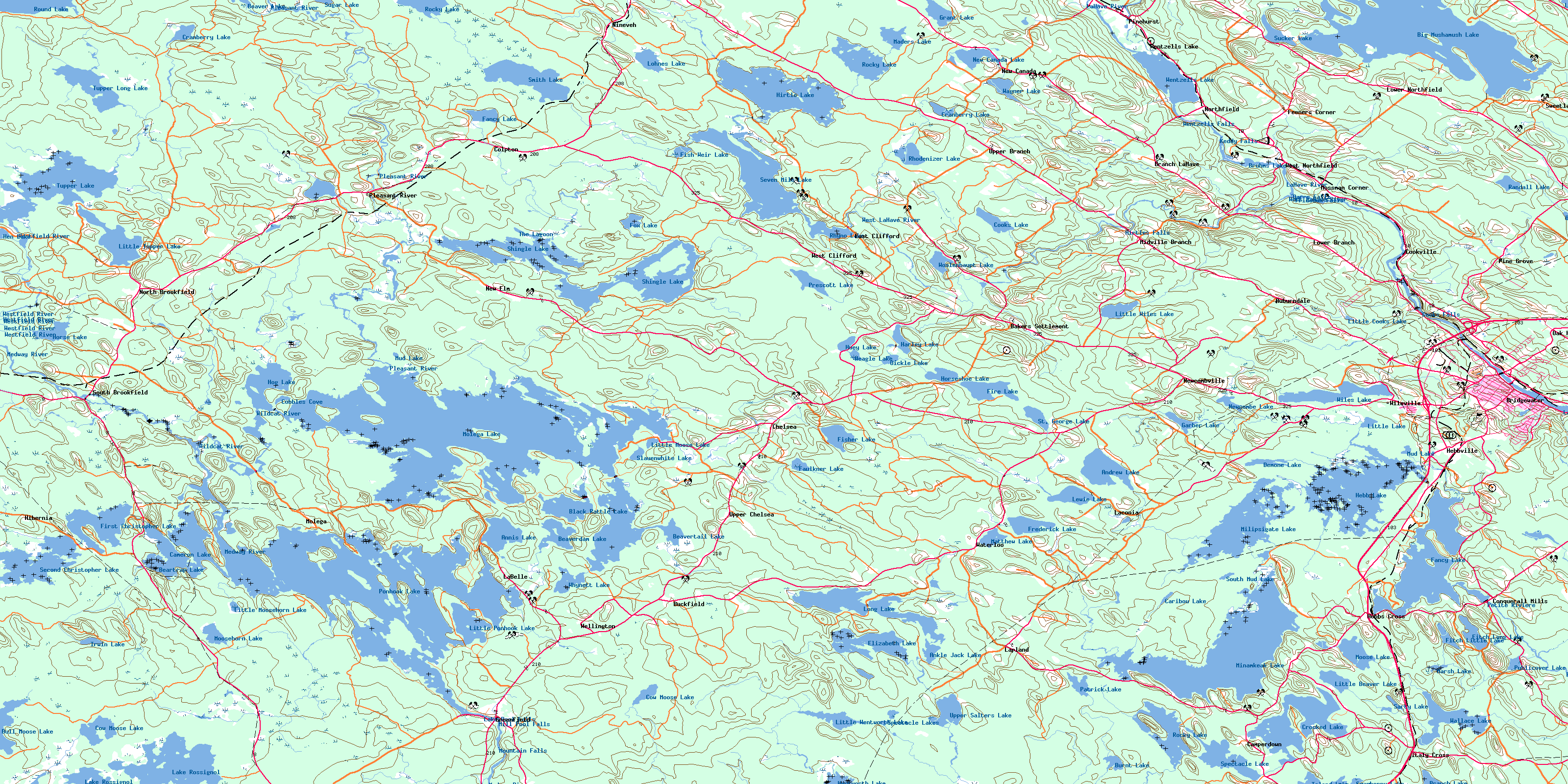
© Department of Natural Resources Canada. All rights reserved.
021A Related Maps:
021A Annapolis Royal021A01 Lahave Islands
021A02 Liverpool
021A03 Lake Rossignol
021A04 Wentworth Lake
021A05 Weymouth
021A06 Kejimkujik Lake
021A07 Bridgewater
021A08 Lunenburg
021A09 Chester
021A10 New Germany
021A11 Milford
021A12 Digby
021A13 Granville Ferry
021A14 Bridgetown
021A15 Gaspereau Lake
021A16 Windsor
