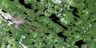
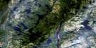
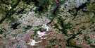
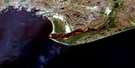
Kegashka Satellite Image Map
Download Free Aerial Photo 012K03 at 1:50,000 scale
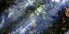
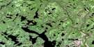
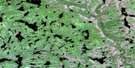
Kegashka Satellite Imagery
To view this satellite map, mouse over the air photo on the right.
You can also download this satellite image map for free:
012K03 Kegashka high-resolution satellite image map.
Maps for the Kegashka aerial map sheet 012K03 at 1:50,000 scale are also available in these versions:
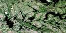
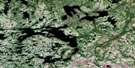
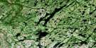
Kegashka Surrounding Area Aerial Photo Maps
 |
 |
 |
 |
 |
 |
 |
 |
 |
 |
 |
 |
 |
 |
 |
 |
© Department of Natural Resources Canada. All rights reserved.
Kegashka Gazetteer
The following places can be found on satellite image map 012K03 Kegashka:
Kegashka Satellite Image: Bays
Anse à JoeAnse aux Huîtres
Anse Muddy
Baie aux Huîtres
Baie de Kégashka
Baie de Kegaska
Baie du Français
Baie Kauahinekaut
Baie Pepihtnahu
Baie Uhatikamekuat
Golfe du Saint-Laurent
Havre de Kegaska
Havre Kégashka
Havre Mistassini
Kegashka Satellite Image: Beaches
Plage MistanekauKegashka Satellite Image: Capes
La Tête d'OursPointe à Bertrand
Pointe à Joe
Pointe Curlew
Pointe de Kégashka
Pointe de Kegaska
Pointe des Jenniss
Pointe du Cap Rouge
Pointe Musquaro
Kegashka Satellite Image: Channels
Étroit du FrançaisKegashka Satellite Image: Geographical areas
Archipel-de-WashicoutaiKégashka
Kegaska
Lalande
Musquaro
Kegashka Satellite Image: Islands
Archipel de WashicoutaiÎle de Kégashka
Île de Kegaska
Île de la Ligne du Télégraphe
Île du Bonnet
Île du Renard
Île Kainipekutihk
Île Kakatshihipinukut
Île Ketshinukuteuat
Île Menahkunakat
Île Noire
Île Parsons
Île Tshiahkuehihat
Île Tshinahat
Île Verte
Îles Iskueakuaniskuaih
Îles Kahakaut
Îles Kippin
Îles Mantuh
Îles Naniuepitam
Îles Pehkuhkat
Îles Uhatshistsh
Rocher du Ruisseau
Rocher Mistahini
Rochers Ehkuahinium
Kegashka Satellite Image: Mountains
Mont Hatsheuiat TshehkahkauKegashka Satellite Image: Rivers
Petite rivière KegaskaRivière à Sam
Rivière Belley
Rivière Clay
Rivière de l'Anse Muddy
Rivière Kégashka
Rivière Kegaska
Rivière Longue
Rivière Musquanousse
Rivière Musquaro
Ruisseau du Rocher Rouge
Kegashka Satellite Image: Shoals
Haut-fond CourtHaut-fond Parsons
Kegashka Satellite Image: Unincorporated areas
KégashkaKegaska
Kegaska
Musquaro
© Department of Natural Resources Canada. All rights reserved.
012K Related Maps:
012K Musquaro012K01 Baie Des Loups
012K02 Gethsemani
012K03 Kegashka
012K04 Natashquan
012K05 Lac Paimpont
012K06 Lac Kegashka
012K07 Lac Washicoutai
012K08 Lac Coacoachou
012K09 Lac Wabouchagamou
012K10 Lac Cauchy
012K11 Lac D'Auteuil
012K12 Lac Victor
012K13 Lac Rancin
012K14 Lac Durocher
012K15 Lac Goyelle
012K16 Lac De Re
