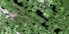
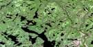
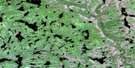
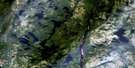
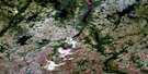
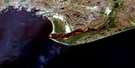
Lac Coacoachou Satellite Image Map
Download Free Aerial Photo 012K08 at 1:50,000 scale
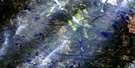
Lac Coacoachou Satellite Imagery
To view this satellite map, mouse over the air photo on the right.
You can also download this satellite image map for free:
012K08 Lac Coacoachou high-resolution satellite image map.
Maps for the Lac Coacoachou aerial map sheet 012K08 at 1:50,000 scale are also available in these versions:
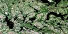
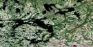
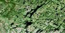
Lac Coacoachou Surrounding Area Aerial Photo Maps
 |
 |
 |
 |
 |
 |
 |
 |
 |
 |
 |
 |
 |
 |
 |
 |
© Department of Natural Resources Canada. All rights reserved.
Lac Coacoachou Gazetteer
The following places can be found on satellite image map 012K08 Lac Coacoachou:
Lac Coacoachou Satellite Image: Bays
Baie CoacoachouBaie des Loups
Baie Tertiary Shell
Lac Coacoachou Satellite Image: Capes
Presqu'île Mahtihantshuapis TatakuahkLac Coacoachou Satellite Image: Geographical areas
DuchesneauLe Gardeur
Liénard
Peuvret
Lac Coacoachou Satellite Image: Islands
Île à l'OursÎle des Esquimaux
Île du Cimetière
Île Hapeuiat
Île Ministukueuetshuan
Île Nakatshauan
Îles Nuhkuau
Lac Coacoachou Satellite Image: Lakes
Lac à FannyLac à l'Ours
Lac Coacoachou
Lac Coconipi
Lac de la Petite Rivière
Lac Foucher
Lac Gagnon
Lac Kahakaukamakaht
Lac Kaku
Lac Kamahkuhiuakamat
Lac Katshihtshekakamat
Lac Kauauiekamat
Lac Long
Lac Maigret
Lac Nehekau
Lac Pien Uhakamehim
Lac Pihiu
Lac Salé
Lac Tetakutakamas
Lac Tshihapeu Uhakatikum
Lac Tshihkuepinahue Kauapmat Atikua
Lac Tshipitnauman
Lacs Anikat Kamamihistiht
Lacs Atikumiskuis
Lacs Mukanipan Katshimihaunan
Lacs Uhkatshiu
The Basin
Lac Coacoachou Satellite Image: Mountains
Colline ConspicuousLac Coacoachou Satellite Image: Rapids
Rapides Uhahimeku PiakuamuhtRapides Uinipeku
Lac Coacoachou Satellite Image: Rivers
Rivière CoacoachouRivière Coconipi
Rivière Grande Romaine
Rivière Olomane
Rivière Uiahtehau
Rivière Wabouchagamou
Lac Coacoachou Satellite Image: Road features
Portage KakahtsheuatakaihitPortage Kauitshamanatauet
Portage Uhiapitshistakan
Lac Coacoachou Satellite Image: Unincorporated areas
Akanekau KauitshihtBaie-des-Loups
Kapenakahkueu Uhtukuan
Mahinaikanapeu Umehkanam
Uapinatsheu Mauahunan
Wolf Bay

© Department of Natural Resources Canada. All rights reserved.
012K Related Maps:
012K Musquaro012K01 Baie Des Loups
012K02 Gethsemani
012K03 Kegashka
012K04 Natashquan
012K05 Lac Paimpont
012K06 Lac Kegashka
012K07 Lac Washicoutai
012K08 Lac Coacoachou
012K09 Lac Wabouchagamou
012K10 Lac Cauchy
012K11 Lac D'Auteuil
012K12 Lac Victor
012K13 Lac Rancin
012K14 Lac Durocher
012K15 Lac Goyelle
012K16 Lac De Re
