Brockville Satellite Image Map
Download Free Aerial Photo 031B12 at 1:50,000 scale
Brockville Satellite Imagery
To view this satellite map, mouse over the air photo on the right.
You can also download this satellite image map for free:
031B12 Brockville high-resolution satellite image map.
Maps for the Brockville aerial map sheet 031B12 at 1:50,000 scale are also available in these versions:
Brockville Surrounding Area Aerial Photo Maps
 |
 |
||
 |
|||
 |
|||
© Department of Natural Resources Canada. All rights reserved.
Brockville Gazetteer
The following places can be found on satellite image map 031B12 Brockville:
Brockville Satellite Image: Bays
Anchorage BayBig Water
Blue Church Bay
Claybank Bay
Cole Bay
Dixons Bay
Eastern Water
Frog Cove
Gailies Bay
Huckleberry Hollow Bay
Kellys Bay
Lily Bay
Little Church Bay
Maitland Bay
McDonald Bay
Sallys Hole
Sand Bay
Sapbush Bay
Sunset Bay
Tunnel Bay
Warren Bay
Brockville Satellite Image: Capes
Blakeys PointBlockhouse Island
Crawford Point
Fulford Point
Heathers Point
Hillcrest Point
Hudsons Point
Hudson's Point
Lemon Point
Lemons Point
Lookout Point
Maple Point
McDonald Point
Sand Bay Point
Watch Hill Point
Weatherheads Point
Brockville Satellite Image: Channels
Brockville NarrowsMollys Gut
Narrows Channel
Brockville Satellite Image: City
BrockvilleBrockville Satellite Image: Geographical areas
AugustaBastard
Edwardsburgh
Elizabethtown
Escott
Front of Escott
Front of Yonge
Grenville
Kitley
Lansdowne
Leeds
Rear of Yonge and Escott
Rear of Yonge and Escott
Yonge
Brockville Satellite Image: Islands
Battersby IslandBig Bluff Island
Brock Group
Brown Island
Browns Island
Cedar Island
Chub Island
Cockburn Island
Conran Island
Crow Island
Crozier Island
Croziers Island
De Rottenburg Island
De Watteville Island
Everest Island
Fawn Island
Fisher Island
Flat Island
Freds Island
Green Island
Hard Island
Harvey Island
Hathaway Island
Jay Ells Island
Little Bluff Island
Long Island
Macnair Island
McCoy Island
McNair Island
Mile Island
Murray Island
Myers Island
Needles Eye Island
Oriental Island
Prince Alfred Island
Princess Island
Raleigh Island
Refugee Island
Rock Island
Royal Island
Savage Island
Sheaffe Island
Silver Island
Skelton Island
Small Bluff Island
Smith Island
Snake Island
Sparrow Island
Spong Island
Stovin Island
Sugar Loaf Island
Three Sisters Islands
Twin Sisters Islands
Victoria Island
Wolf Island
Wolfe Island
Brockville Satellite Image: Lakes
Atkins LakeBasin Lake
Buells Creek Reservoir
Centre Lake
Charleston Lake
Graham Lake
Irish Lake
Lake Eloida
Lambs Pond
Lees Pond
Loyada Lake
Lyn Pond
Mud Lake
Mud Lake
Mud Lake
Temperance Lake
Wiltse Lake
Brockville Satellite Image: Mountains
Fells HillPainted Rocks
Brockville Satellite Image: Major municipal/district area - major agglomerations
United Counties of Leeds and GrenvilleBrockville Satellite Image: Other municipal/district area - miscellaneous
AthensAugusta
Bastard and South Burgess
Edwardsburgh
Edwardsburgh/Cardinal
Elizabethtown
Elizabethtown-Kitley
Front of Escott
Front of Leeds and Lansdowne
Front of Yonge
Kitley
Leeds and the Thousand Islands
North Crosby
Rear of Leeds and Lansdowne
Rear of Yonge and Escott
Rideau Lakes
South Crosby
South Elmsley
Brockville Satellite Image: Conservation areas
Buell's Creek Conservation AreaCharleston Lake Provincial Park
Fort Wellington National Historic Site of Canada
Lieu historique national du Canada du Fort-Wellington
Parc national du Canada des Îles-du-Saint-Laurent
St. Lawrence Islands National Park of Canada
Brockville Satellite Image: Provinces
OntarioBrockville Satellite Image: Rivers
Beales CreekBradleys Creek
Buells Creek
Butlers Creek
Charleville Creek
Cole Creek
Elbe Creek
Fleuve Saint-Laurent
Fosters Creek
Golden Creek
Grants Creek
Hard Island Creek
Johnstown Creek
Jones Creek
Leaders Creek
Leeders Creek
Lemons Creek
Little Mud Creek
Lyn Creek
MacIlhennys Creek
Marsh Creek
Marshalls Creek
Mud Creek
North Wiltse Creek
Plum Hollow Creek
Rivière Nation
Smades Creek
South Branch Plum Hollow Creek
South Kemptville Creek
South Nation River
St. Lawrence River
Wells Creek
Wiltse Creek
Brockville Satellite Image: Shoals
Cole Ferry ShoalCole Shoal
Coronation Shoal
Eagle Rock
McDonald Point Shoal
North McNair Shoal
South McNair Shoal
Union Park Shoal
Brockville Satellite Image: Towns
PrescottBrockville Satellite Image: Unincorporated areas
AddisonAlgonquin
Anoma Lea
Athens
Ballycanoe
Beales Mills
Bellamys
Bethel
Bisseltown
Blue Church
Butternut Bay
Caintown
Charleston
Charleville
Clark
Eloida
Fairfield
Fairfield East
Fernbank
Flanders Heights
Forthton
Frankville
Glen Buell
Glen Elbe
Glen Morris
Glenmore
Golf Side Gardens
Greenbush
Hallecks
Hawken
Hawkes
Hayes Corners
Herrons Corners
Hillcrest
Jelly
Jellyby
Junetown
Lehighs Corners
Lillies
Lord Mills
Lords Mills
Loyalist Park
Lyn
Maitland
Manhard
Maynard
McIntosh Mills
New Dublin
Redan
Riverview Heights
Rocksprings
Rows Corners
Seeley
Sheatown
Sheridan Park
Sherwood Spring
Sherwood Springs
South Augusta
Sparkle City
Spring Valley
Stones Corners
Tincap
Toledo
Trevelyan
Wexford
Wights Corners
Wiltsetown
Windsor Heights
Woodridge
Yonge Mills
Brockville Satellite Image: Low vegetation
Long SwampBrockville Satellite Image: Villages
Fairfield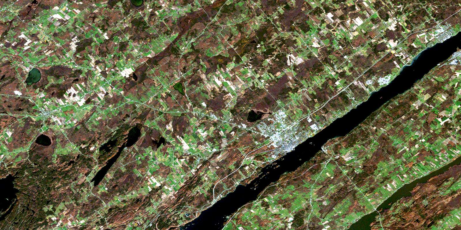
© Department of Natural Resources Canada. All rights reserved.
