Swanson River Topo Map Online
Download Free Topo Map Sheet 042B03 at 1:50,000 scale
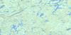
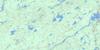
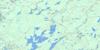
042B03 Swanson River Topo Map
To view this map, mouse over the map preview on the right.
You can also download this topo map for free:
042B03 Swanson River high-resolution topo map image.
Maps for the Swanson River topo map sheet 042B03 at 1:50,000 scale are also available in these versions:
Swanson River Surrounding Area Topo Maps
 |
 |
 |
 |
 |
 |
 |
 |
 |
 |
 |
 |
 |
 |
 |
 |
© Department of Natural Resources Canada. All rights reserved.
Swanson River Gazetteer
The following places can be found on topographic map sheet 042B03 Swanson River:
Swanson River Topo Map: Geographical areas
AlcornBrutus
Chaplin
Chewett
Clifton
Collins
Copperfield
D'Arcy
Floranna
Hill
Lipsett
Mageau
Manning
Marshall
McGee
Pattinson
Racine
Ramsden
Sadler
Swanson River Topo Map: Lakes
Alcorn LakeBrutus Lake
Chagma Lake
East Chaplin Lake
East Mageau Lake
Floranna Lake
Frog Lake
Grew Lake
Hambone Lake
Hay Lake
Lipsett Lake
Little Racine Lake
Little Stump Lake
Mageau Lake
Marshall Lake
Morn Lake
Nemegosenda Lake
Pats Lake
Poach Lake
Racine Lake
Ramsden Lake
Rapat Lake
Robson Lake
Schewabik Lake
Stump Lake
Upper Windermere Lake
Valere Lake
Van Lake
Yoyo Lake
Swanson River Topo Map: Conservation areas
Chapleau-Nemegosenda River Provincial ParkSwanson River Topo Map: Rivers
Adams CreekChapleau River
Chaplin River
Hay River
Little Hay River
Little Swanson River
Nemegosenda River
Racine Creek
Rivière Chapleau
Rivière Nemegosenda
Sauce Creek
Swanson River
© Department of Natural Resources Canada. All rights reserved.
042B Related Maps:
042B Foleyet042B01 Foleyet
042B02 Ivanhoe Lake
042B03 Swanson River
042B04 Bolkow
042B05 Missinaibi Lake
042B06 Makonie Lake
042B07 Missonga
042B08 Oswald Lake
042B09 Elf Lake
042B10 Elsas
042B11 Peterbell
042B12 Greenhill River
042B13 Minnipuka
042B14 Ericson Creek
042B15 Allenby Creek
042B16 Griffin Lake
