Spruce Island Topo Map Online
Download Free Topo Map Sheet 063F02 at 1:50,000 scale
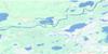
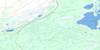
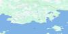
063F02 Spruce Island Topo Map
To view this map, mouse over the map preview on the right.
You can also download this topo map for free:
063F02 Spruce Island high-resolution topo map image.
Maps for the Spruce Island topo map sheet 063F02 at 1:50,000 scale are also available in these versions:
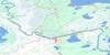
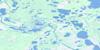
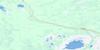
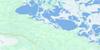
Spruce Island Surrounding Area Topo Maps
 |
 |
 |
 |
 |
 |
 |
 |
 |
 |
 |
 |
 |
 |
 |
 |
© Department of Natural Resources Canada. All rights reserved.
Spruce Island Gazetteer
The following places can be found on topographic map sheet 063F02 Spruce Island:
Spruce Island Topo Map: Bays
Cameron BayCampbell Bay
Dawson Bay
Harrisons Bay
Jackfish Bay
Mill Bay
Muddy Bay
North Shore Bay
Overflow Bay
Spruce Island Topo Map: Capes
Cameron PointDeer Point
Elm Tree Point
Harrisons Point
Hunters Point
Little Whitefish Point
Mill Point
Nestors Point
Rippers Point
Spruce Island Topo Map: Channels
North ChannelSouth Channel
Spruce Island Topo Map: Indian Reserves
Sapotaweyak Cree Nation - Spruce IslandSpruce Island Topo Map: Islands
Little Shannon IslandSpruce Island
Spruce Island Topo Map: Lakes
Lac WinnipegosisLake Winnipegosis
Spruce Island Topo Map: Conservation areas
Swan-Pelican Provincial ForestSpruce Island Topo Map: Rivers
North Shore CreekSwamp Creek
Spruce Island Topo Map: Shoals
Doris Reef
© Department of Natural Resources Canada. All rights reserved.
063F Related Maps:
063F The Pas063F01 Mossy Portage
063F02 Spruce Island
063F03 Overflowing River
063F04 Chemong Creek
063F05 Turnberry
063F06 No Title
063F07 Connolly Bay
063F08 Kokookuhoo Island
063F09 Lamb Lake
063F10 Red Earth Lake
063F11 Pasquia Lake
063F12 Culdesac Lake
063F13 Barrier Lake
063F14 The Pas
063F15 Landry Lake
063F16 Crossing Bay
