Hope Topo Map Online
Download Free Topo Map Sheet 092H06 at 1:50,000 scale
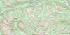
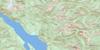
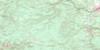
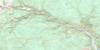
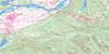
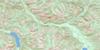
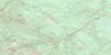
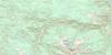
092H06 Hope Topo Map
To view this map, mouse over the map preview on the right.
You can also download this topo map for free:
092H06 Hope high-resolution topo map image.
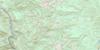
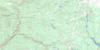
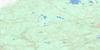
Maps for the Hope topo map sheet 092H06 at 1:50,000 scale are also available in these versions:
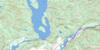
Hope Surrounding Area Topo Maps
 |
 |
 |
 |
 |
 |
 |
 |
 |
 |
 |
 |
 |
 |
 |
 |
© Department of Natural Resources Canada. All rights reserved.
Hope Gazetteer
The following places can be found on topographic map sheet 092H06 Hope:
Hope Topo Map: Beaches
Texas BarHope Topo Map: District municipality
HopeHope Topo Map: Indian Reserves
Aywawwis Indian Reserve 15Greenwood Island Indian Reserve 3
Hope Indian Reserve 1
Kawkawa Lake Indian Reserve 16
Kaykaip Indian Reserve 7
Klaklacum Indian Reserve 12
Puckatholetchin Indian Reserve 11
Réserve indienne Aywawwis 15
Réserve indienne Greenwood Island 3
Réserve indienne Hope 1
Réserve indienne Kawkawa Lake 16
Réserve indienne Kaykaip 7
Réserve indienne Klaklacum 12
Réserve indienne Puckatholetchin 11
Réserve indienne Schkam 2
Réserve indienne Skawahlum 10
Réserve indienne Stullawheets 8
Réserve indienne Swahliseah 14
Réserve indienne Trafalgar Flat 13
Réserve indienne Tunnel 6
Schkam Indian Reserve 2
Skawahlum Indian Reserve 10
Stullawheets Indian Reserve 8
Swahliseah Indian Reserve 14
Trafalgar Flat Indian Reserve 13
Tunnel Indian Reserve 6
Hope Topo Map: Islands
Bristol IslandCroft Island
Greenwood Island
Strawberry Island
Hope Topo Map: Lakes
Devil LakeDevils Lake
Dry Lake
Eaton Lake
Ghostpass Lake
Grant Pond
Jacobson Lake
Kawkawa Lake
Kippan Lakes
Klahater Lake
Outram Lake
Palmer Pond
Schkam Lake
Silver Lake
Squeah Lake
Hope Topo Map: Mountains
Bedded RangeCascade Mountains
Chaîne Côtière
Coast Mountains
Dog Mountain
Emancipation Mountain
Hope Mountain
Hozameen Range
Isolillock Peak
Johnson Peak
Jorgenson Peak
Lillooet Ranges
Macleod Peak
Manson Ridge
Mount Coulter
Mount Davis
Mount Dewdney
Mount Ford
Mount Hatfield
Mount Jarvis
Mount Outram
Mount Potter
Mount Snider
Mount Stoneman
Mount Sutter
Ogilvie Peak
Pacific Ranges
Silver Peak
Skagit Range
Squeah Mountain
Treasure Mountain
Tulameen Mountain
Wells Peak
Zofka Ridge
Hope Topo Map: Major municipal/district area - major agglomerations
Fraser Valley Regional DistrictRegional District of Fraser-Cheam
Hope Topo Map: Conservation areas
Cascade Recreation AreaCoquihalla Canyon Park
Coquihalla Canyon Recreation Area
Coquihalla River Park
Coquihalla River Recreation Area
E.C. Manning Park
Kawkawa Lake Park
Nicolum Park
Nicolum River Park
Silver Lake Park
Hope Topo Map: Rivers
Alexander CreekAmberty Creek
American Creek
Angus Creek
Berkey Creek
Boston Bar Creek
Bushby Creek
Camilos Creek
Carry Creek
Cedarflat Creek
Chevreuil Creek
Chisholm Creek
Colvile Creek
Coquihalla River
Cunningham Creek
Deneau Creek
Dewdney Creek
East Snass Creek
Eaton Creek
Eight Mile Creek
Eighteen Mile Creek
Eighteenmile Creek
Eleven Mile Creek
Emory Creek
Eureka Creek
Ferguson Creek
Fifteen Mile Creek
Fleuve Fraser
Fraser River
Fuller Creek
Galvez Creek
Ghostpass Creek
Jessica Creek
Jim Kelly Creek
Karen Creek
Kawkawa Creek
Keikum Creek
Kopp Creek
Ladner Creek
Maimen Creek
Matthew Creek
McColl Creek
Menz Creek
Montigny Creek
Nicolum Creek
Nicolum River
Nine Mile Creek
Ogilvie Creek
Ophelia Creek
O'Reilly Creek
Peers Creek
Podunk Creek
Potter Creek
Prospectors Creek
Puckat Creek
Railroad Creek
Railway Creek
Rice Creek
Richmond Creek
Schkam Creek
Seventeen Mile Creek
Silverhope Creek
Snass Creek
Sowaqua Creek
Sowerby Creek
Stockholm Creek
Stulkawhits Creek
Sucker Creek
Suka Creek
Sumallo River
Sutter Creek
Tangent Creek
Ten Mile Creek
Thacker Creek
Twenty Mile Creek
Two Mile Creek
Vuich Creek
Wray Creek
Hope Topo Map: Unincorporated areas
ChoateDogwood Valley
Haig
Jessica
Lear
Odlum
Othello
Petain
Silver Creek
Squeah
Sunshine Valley
Tashme
Trafalgar
Hope Topo Map: Valleys
Fools PassGhost Pass
Hope Topo Map: Low vegetation
Gibson Meadows
© Department of Natural Resources Canada. All rights reserved.
092H Related Maps:
092H Hope092H01 Ashnola River
092H02 Manning Park
092H03 Skagit River
092H04 Chilliwack
092H05 Harrison Lake
092H06 Hope
092H07 Princeton
092H08 Hedley
092H09 Bankeir
092H10 Tulameen
092H11 Spuzzum
092H12 Mount Urquhart
092H13 Scuzzy Mountain
092H14 Boston Bar
092H15 Aspen Grove
092H16 Paradise Lake
