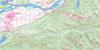
Chilliwack Topo Map Online
Download Free Topo Map Sheet 092H04 at 1:50,000 scale
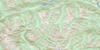
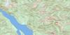
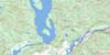
092H04 Chilliwack Topo Map
To view this map, mouse over the map preview on the right.
You can also download this topo map for free:
092H04 Chilliwack high-resolution topo map image.
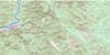
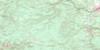
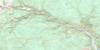
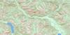
Maps for the Chilliwack topo map sheet 092H04 at 1:50,000 scale are also available in these versions:
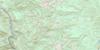
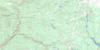
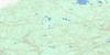
Chilliwack Surrounding Area Topo Maps
 |
 |
 |
 |
 |
 |
 |
 |
 |
 |
 |
 |
 |
 |
 |
 |
© Department of Natural Resources Canada. All rights reserved.
Chilliwack Gazetteer
The following places can be found on topographic map sheet 092H04 Chilliwack:
Chilliwack Topo Map: Bays
Entrance BayHarrison Bay
Maple Bay
Chilliwack Topo Map: Caves
Chipmunk CavesSlesse Creek Cave
Chilliwack Topo Map: City
ChilliwackChilliwack Topo Map: District municipality
KentChilliwack Topo Map: Falls
Bridal Veil FallsChilliwack Topo Map: Geographical areas
New Westminster Land DistrictYale Division Yale Land District
Chilliwack Topo Map: Glaciers
Foley GlacierLucky Four Glacier
Stewart Glacier
Wahleach Glacier
Chilliwack Topo Map: Indian Reserves
Aitchelitch Indian Reserve 9Cheam Indian Reserve 1
Grass Indian Reserve 15
Kwawkwawapilt Indian Reserve 6
Popkum Indian Reserve 1
Popkum Indian Reserve 2
Réserve indienne Aitchelitch 9
Réserve indienne Cheam 1
Réserve indienne Grass 15
Réserve indienne Kwawkwawapilt 6
Réserve indienne Popkum 1
Réserve indienne Popkum 2
Réserve indienne Schelowat 1
Réserve indienne Scowlitz 1
Réserve indienne Seabird Island
Réserve indienne Skowkale 10
Réserve indienne Skowkale 11
Réserve indienne Skulkayn 10
Réserve indienne Skulkayn 11
Réserve indienne Skumalasph 16
Réserve indienne Skwah 4
Réserve indienne Skwahla 2
Réserve indienne Skwali 3
Réserve indienne Skway 5
Réserve indienne Soowahlie 14
Réserve indienne Squawkum Creek 3
Réserve indienne Squiaala 7
Réserve indienne Squiaala 8
Réserve indienne Tseatah 2
Réserve indienne Tzeachten 13
Réserve indienne Williams 2
Réserve indienne Yakweakwioose 12
Schelowat Indian Reserve 1
Scowlitz Indian Reserve 1
Seabird Island Indian Reserve
Skowkale Indian Reserve 10
Skowkale Indian Reserve 11
Skulkayn Indian Reserve 10
Skulkayn Indian Reserve 11
Skumalasph Indian Reserve 16
Skwah Indian Reserve 4
Skwahla Indian Reserve 2
Skwali Indian Reserve 3
Skway Indian Reserve 5
Soowahlie Indian Reserve 14
Squawkum Creek Indian Reserve 3
Squiaala Indian Reserve 7
Squiaala Indian Reserve 8
Tseatah Indian Reserve 2
Tzeachten Indian Reserve 13
Williams Indian Reserve 2
Yakweakwioose Indian Reserve 12
Chilliwack Topo Map: Islands
Cottonwood IslandFairfield Island
Herrling Island
Hog Island
Queens Island
Rose Island
Rosebank Island
Sea Bird Island
Seabird Island
Windermere Island
Chilliwack Topo Map: Lakes
Agassiz SloughBateson Slough
Bell Slough
Camp Slough
Cheam Lake
Cheam Slough
Coco-oppelo Slough
Cultus Lake
Duncan Slough
Foley Lake
Gravel Slough
Greyell Slough
Hogg Slough
Hope Slough
Ling Lake
Liumchen Lake
Maria Slough
Mountain Slough
Nelson Slough
Nicomen Slough
Pierce Lake
Ryder Lake
Sardis Pond
Shefford Slough
Wahleach Lake
Williamson Lake
Chilliwack Topo Map: Mountains
Baby Munday PeakBorder Peak
Canadian Border Peak
Cascade Mountains
Cemetery Hill
Cheam Peak
Cheam Range
Cheam Ridge
Church Mountain
Conway Peak
Crossover Peak
Elk Mountain
Foley Peak
Four Brothers
Goetz Peak
Harrison Hill
Harrison Knob
Hopyard Hill
Illusion Peaks
International Ridge
Isar Mountain
Knight Peak
Lady Peak
Liumchen Mountain
Lookout Ridge
Mount Amadis
Mount Archibald
Mount Cope
Mount Corriveau
Mount Laughington
Mount Ling
Mount MacFarlane
Mount McGuire
Mount Mercer
Mount Parkes
Mount Pierce
Mount Rexford
Mount Shannon
Mount Thurston
Mount Tom
Skagit Range
Slesse Mountain
Spencer Peak
Stewart Peak
Teapot Hill
The Still
Vedder Mountain
Welch Peak
Williams Peak
Chilliwack Topo Map: Major municipal/district area - major agglomerations
Dewdney-Alouette Regional DistrictFraser Valley Regional District
Regional District of Fraser-Cheam
Chilliwack Topo Map: Conservation areas
Bridal Veil Falls ParkChilliwack River Park
Cultus Lake Park
Ferry Island Park
International Ridge Park
International Ridge Recreation Area
Kilby General Store Museum
Kilby Historic Park
Kilby Park
Meadowland Park
Chilliwack Topo Map: Plains
Larsons BenchChilliwack Topo Map: Provinces
British ColumbiaColombie-Britannique
Chilliwack Topo Map: Rivers
Airplane CreekAmadis Creek
Anderson Creek
Ascaphus Creek
Atchelitz Creek
Borden Creek
Bridal Creek
Calkins Creek
Centre Creek
Chilliwack Creek
Chilliwack River
Chilliwack River
Chipmunk Creek
Clear Creek
Dunville Creek
East Liumchen Creek
Elk Brook
Elk Creek
Fin Creek
Fleuve Fraser
Foley Creek
Ford Creek
Fraser River
Harrison River
Hatchery Creek
Laurel Creek
Little Chilliwack River
Little Tamihi Creek
Liumchen Creek
Luckakuck Creek
Marblehill Creek
McCallum Ditch
Midgley Creek
Nesakwatch Creek
Nevin Creek
Nursery Creek
Pierce Creek
Ryder Creek
Sasin Creek
Seedling Creek
Semmihault Creek
Slesse Creek
Smith Falls Creek
Squakum Creek
Squawkeem Creek
Squawkum Creek
Sweltzer River
Tamihi Creek
Teapot Creek
Vedder River
Wahleach Creek
Watt Creek
Wells Creek
Williamson Creek
Windfall Creek
Wingfield Creek
Young Creek
Chilliwack Topo Map: Unincorporated areas
AgassizBridal Falls
CFB Chilliwack
Cheam
Chilliwack
Cultus Lake
East Chilliwack
Fairfield
Greenacres
Harrison Mills
Magellan
Minto
Minto Landing
Popkum
Promontory
Promontory Heights
Rosedale
Ryder Lake
Sardis
Slesse Park
Smithvale
South Sumas
Vedder Crossing
Wells
Westview Subdivision

© Department of Natural Resources Canada. All rights reserved.
092H Related Maps:
092H Hope092H01 Ashnola River
092H02 Manning Park
092H03 Skagit River
092H04 Chilliwack
092H05 Harrison Lake
092H06 Hope
092H07 Princeton
092H08 Hedley
092H09 Bankeir
092H10 Tulameen
092H11 Spuzzum
092H12 Mount Urquhart
092H13 Scuzzy Mountain
092H14 Boston Bar
092H15 Aspen Grove
092H16 Paradise Lake
