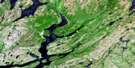
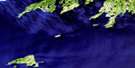
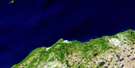
Ship Cove Satellite Image Map
Download Free Aerial Photo 001M01 at 1:50,000 scale
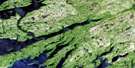
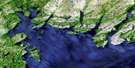
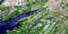
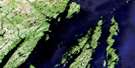
Ship Cove Satellite Imagery
To view this satellite map, mouse over the air photo on the right.
You can also download this satellite image map for free:
001M01 Ship Cove high-resolution satellite image map.
Maps for the Ship Cove aerial map sheet 001M01 at 1:50,000 scale are also available in these versions:
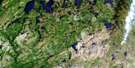
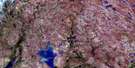
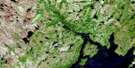
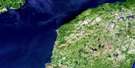
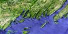
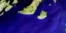
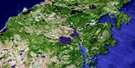
Ship Cove Surrounding Area Aerial Photo Maps
 |
 |
 |
 |
 |
 |
 |
 |
 |
 |
 |
 |
 |
 |
 |
 |
© Department of Natural Resources Canada. All rights reserved.
Ship Cove Gazetteer
The following places can be found on satellite image map 001M01 Ship Cove:
Ship Cove Satellite Image: Bays
Angels CoveAngel's Cove
Back Cove
Ballast Cove
Big Cove
Big Gull Rock Cove
Carols Cove
Dog Brook Cove
Doyles Cove
Glennons Cove
Gooseberry Cove
Great Barasway
Halfway Brook Cove
Harry Cove
Ice House Cove
Little Barasway Cove
Little Cove
Little Gull Rock Cove
Little Meadow Cove
Long Point Cove
Miners Cove
Patrick's Cove
Placentia Bay
Placentia Road
Rocky Cove
Seal Rocks Cove
Ship Cove
Shoe Cove
Stoney House Bight
Valley of Diamonds
Ship Cove Satellite Image: Beaches
Cape ShoreHarry Cove Beach
Kittys Beach
Ship Cove Satellite Image: Capes
Avalon PeninsulaBlack Point
Caroline Browns Point
Down Point
Grassy Point
Grassy Point
Green Point
Grepes Nest
Halfway Gully Point
Little Meadow Point
North Point
North Point of Angels Cove
North Point of Gooseberry
Norther Point
Otter Rub Point
Point Verde
Seal Point
Shoal Point
Souther Point
Stake Point
Sunker Point
Tommy Doyles Point
Wester Point
Wester Point of Gooseberry
Woody Point
Ship Cove Satellite Image: Cliffs
Conways FillShip Cove Satellite Image: Falls
Big FallsShip Cove Satellite Image: Forests
Big TuckDoyles Tuck
Ship Cove Satellite Image: Lakes
Beachy PondBig Rock Pond
Corcorans Pond
Dry Pond
Easter Brook Ponds
Feeders
Gate Brook Pond
Glennons Cove Pond
Goose Pond
Great Barasway Pond
Halfway Brook Pond
Hare Hill Pond
Inside Gully
James Brennans Gully
Lily Pond
Little Meadow Pond
Long Jims Hay
Lookout Pond
Patricks Cove Pond
Point Verde Pond
Round Pond
The Downs
Ship Cove Satellite Image: Mountains
Angels LookoutBunk Peak
Great Barasway Lookout
Hare Hill
High Hill
Hill of the Gully
Patricks Lookout
Platform Hills
Ship Cove Dry Hill
Ship Cove Lookout
Sugarloaf
Sugarloaf Peak
Tommy Doyles Hill
Ship Cove Satellite Image: Conservation areas
Gooseberry Cove Provincial ParkShip Cove Satellite Image: Rivers
Angels Cove BrookBeaver Pond Gully
Big Brook
Branch River
Bulgers Feeder
Coxs of Hay Gully
Dog Brook
East Brook
Easter Brook
Eastern Pinnacle Gully
Feeders River
First Gully
Gate Brook
Glennons Cove River
Halfway Brook
Halfway Brook
Halfway Gully
Hare Hill Gully
Harry Cove River
James Brennans River
Leap Brook
Little Barachois River
Little Barasway River
Little Brook
Little Meadow River
Michael Brennans Gully
Mid Pinnacle Gully
Middle Brook
North Brook
Patricks Cove Brook
Powder Horn Brook
Seal Rocks River
Second Gully
Ship Cove Brook
South Brook
South Brook
Souther Brook
Souther Tuck Gully
Southern Brook
Stoney House Brook
Viscount Bridge Gully
Western Pinnacle Gully
Ship Cove Satellite Image: Shoals
False GirdleGibraltar Rock
Girdle Rock
Goose Shoal
Lower Big Shoal
Merasheen Bank
Patrick's Rock
South Rock
Southern Ridge
Upper Big Shoal
Virgin Rocks
Ship Cove Satellite Image: Unincorporated areas
Angels CoveAngel's Cove
Gooseberry Cove
Great Barasway
Little Barasway
Patrick's Cove
Patrick's Cove-Angels Cove
Point Verde
Ship Cove
Stoney House
Ship Cove Satellite Image: Valleys
Hells DrookShip Cove Satellite Image: Low vegetation
Easter Brook MarshesGooseberry Forks
Little Meadow Mash
Patricks Cove Fork

© Department of Natural Resources Canada. All rights reserved.
001M Related Maps:
001M Belleoram001M01 Ship Cove
001M02 Jude Island
001M03 Marystown
001M04 Grand Bank
001M05 Harbour Breton
001M06 Point Entragee
001M07 Baine Harbour
001M08 Merasheen
001M09 Harbour Buffett
001M10 Terrenceville
001M11 Belleoram
001M12 Gaultois
001M13 St Alban's
001M14 Hungry Grove Pond
001M15 Gisborne Lake
001M16 Sound Island
